**This is an archival project page. NOAA retired the HWRF model in 2022 and transitioned to the new Hurricane Analysis and Forecasting System (HAFS) model for 2023. Please visit the Hurricane Modeling and Prediction Page for more information about HAFS.**
AOML’s Hurricane Modeling Group developed the Hurricane Weather Research Forecast (HWRF) model from the working group’s formation in 2007 through 2022 when it was retired in favor of the next generation Hurricane Analysis & Forecasting System (HAFS).
From a Successful Transition to Operations
As a result of the these diligent efforts, unparalleled support by NOAA’s Hurricane Forecast Improvement Project, and close collaborative research work with the Environmental Modeling Center, the improved HWRF model was incorporated as one of the National Hurricane Center’s operational hurricane forecasting models beginning with the 2012 season and continuing through 2022 when we ran the next generation modeling system HAFS concurrently. For 2023 we are transitioning to solely to the Hurricane Analysis & Forecasting System and will continue its development.
Improved forecasts benefit emergency managers along coastal areas of the US, reducing warning times and the extent of evacuation areas, thus saving lives, helping to mitigate property damage and increasing the public’s confidence in NOAA’s official hurricane forecasts and warnings.
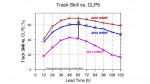
Overall, HWRF has improved its track prediction skills by 40% to 60%.
Source: HFIP Annual Report (2018)
In 2018, the HWRF model was upgraded to run at a horizontal resolution of 1.5 km near storm region. This makes HWRF the highest resolution hurricane model ever implemented for operations in the National Weather Service.
Source: HFIP Annual Report (2018)
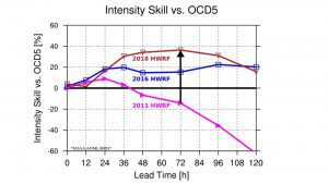
Overall, HWRF has improved its intensity prediction skills by a minimum of 40% to 60%.
Source: HFIP Annual Report (2018)
Evolution of the Hurricane Modeling System
HWRF
A Foundational Model
HWRF was transitioned to operations at NOAA’s National Centers for Environmental Prediction in 2007. From 2008-2011, scientists at AOML developed an experimental HWRF to target the intensity change problem. The experimental HWRF incorporated a movable multilevel nesting algorithm with planetary boundary layer and surface physics, carefully calibrated by in situ observations obtained from the hurricane inner-core region. These developments formed the backbone of the operational HWRF and resulted in continuous improvements to its track, intensity and structure predictions in the following years.
Using cutting-edge numerical modeling and verification techniques, our research has helped accelerate the advancement of the model’s development and has played a key role in the success of the Hurricane Forecast Improvement Project. These achievements provide hurricane forecasters not only with improved forecast guidance, but also with critical information on the evolution of the three dimensional wind structure within the storm.
HWRF-B
Cutting Edge Capabilities
The Basin-scale HWRF modeling system (HWRF-B), an upgrade of the HWRF for potential Research-to-Operations transition, was developed at AOML in collaboration with other organizations under the auspices of the Hurricane Forecast Improvement Project. HWRF-B includes two salient improvements over the operational HWRF system: a large, static outermost domain that spans a quarter of the tropical belt; and multiple sets of movable multi-level nests that can follow multiple storms simultaneously.
HWRF-B is currently utilized as a framework for innovative research and an experimental tool for research-to-operations implementations. This unique NOAA capacity will be the baseline for future transitions to next-generation hurricane modeling systems, e.g. the Hurricane Analysis and Forecast System (HAFS).
FV3 HAFS
Next Generation Modeling
The Hurricane Analysis and Forecast System (HAFS) is NOAA’s next-generation numerical model and data assimilation system developed within the framework of the Uniform Forecast System (UFS). HAFS aims to provide reliable and skillful guidance on tropical cyclone track, intensity, and structure, including rapid intensity changes, genesis, and storm size.
AOML’s Hurricane Modeling group is actively involved in the development of HAFS, along with partners throughout NOAA. One important HAFS development will be the advancement of the model dynamical core to include high-resolution moving nests. Our group is also actively involved in the development and evaluation of changes to model physics by using the high-quality observations collected in the Hurricane Field Program.
Hurricane Weather Research Forecast Model
“In 2007, NOAA’s HWRF model was officially adopted by the National Hurricane Center. Since then, the numerical modeling at AOML has greatly advanced NOAA’s HWRF model.”
–HFIP Annual Report (2018)
The HWRF model is a storm-following, double-nested, high-resolution, grid modeling system designed to operate at a horizontal resolution of 2 km or less. It was designed for capturing tropical cyclone inner core processes, including interactions with the large-scale processes which have been proven to be critical for improving track, intensity, rainfall and size predictions. HWRF was initially developed for improving intensity guidance, but is also used to provide some reliable track guidance, together with the Global Forecasting System and other models.
HWRF’s development and its transition to operations is one of the major accomplishments of NOAA’s Hurricane Forecast Improvement Project. HWRF has become one of the top performing operational models for track and intensity predictions-in 2018, its average intensity error for tropical cyclones in the North Atlantic Ocean was less than 16 kt through five days (Read the Forecast Verification Report). HWRF is increasing the reliability of operational forecast guidance and is paving the way to next-generation model developments.
HWRF is the driving dynamical model of the Real-Time Hurricane Forecast Improvement Project Corrected Consensus Approach (HCCA) for Tropical Cyclone Intensity Guidance at the National Hurricane Center, and has become the flagship intensity prediction tool for hurricane forecasting at the National Weather Service. The High-resolution HWRF model was developed through state-of-the-art research involving the following key elements:
- High-resolution numerical model developments.
- Advancements to physical parameterizations for hurricane models based on observations.
- Advancements in the basic understanding of the multi-scale interactions and physical processes that govern the evolution of tropical cyclones.
Building a Weather-Ready Nation
with Basin-Scale Modeling
AOML’s Hurricane Modeling Group upgraded the foundational HWRF model to include new capabilities like the production of simultaneous tropical cyclone forecasts and a much higher resolution environment. It also served as a prototype for the development of multiple moving, multi-level nests within the global model. This model, called the “Basin-scale HWRF” (HWRF-B), was also a testbed for research aimed at improving predictions of storm-storm, land-storm, and other multi-scale interactions.
Statistical Dynamical Modeling
Tropical Cyclone Rapid Intensification Prediction
Rapid intensification occurs in over 80% of major hurricanes and all category four and five hurricanes in the Atlantic Basin. The largest operational intensity forecast errors occur due to the difficulty in forecasting processes relating to rapid intensification. This means that improving the forecasting of these storms is a major priority as was specified in the 2017 Weather Research and Forecasting Innovation Act and the Hurricane Forecast Improvement Program.
A suite of models has been developed with support from NOAA’s Joint Hurricane Testbed to aid forecasters at the National Hurricane Center in predicting rapid intensification in both the Atlantic and Pacific basins. These models use the National Center for Environmental Prediction’s global model output and satellite data to estimate the probability that a tropical cyclone will undergo rapid intensification at a given lead time (defined as the 95th percentile of over-water tropical cyclone intensity change).
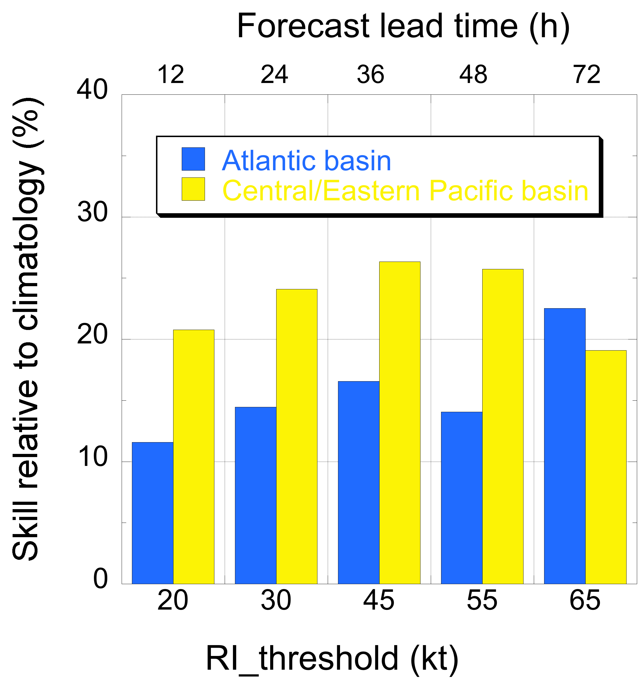
One such model that was developed jointly by researchers from AOML, NHC, and NOAA/NESDIS is commonly referred to as the SHIPS rapid intensification index (SHIPS-RII). It uses linear discriminant analysis to estimate the probability of rapid intensification. Although initially developed for the single forecast lead time of 24-h, in recent years the model was developed for the added lead times of 12-h, 36-h, 48-h and 72-h. See the figures to the right to learn more about the outputs for the SHIPS-RII tool.
To read more about the SHIPS-RII model, click on each subject below, or download the most recent publication:
Forecast Skill
Figure 1 shows the skill of the SHIPS-RII for the 4-year (2016-2019) period during which the multi-lead time forecasts were first made available to the NHC. The figure indicates that the SHIPS-RII forecasts were skillful relative to climatology (see Kaplan et al. 2015 for more information about the verification methodology) in both the Atlantic and eastern/Central Pacific basins with significantly more skill displayed by the SHIPS-RII in the latter basin.
Reliability Diagram
Figure 2 provides reliability diagrams depicting the forecasted versus observed probability of rapid intensification for that same 4-year operational sample in both the Atlantic and eastern/Central Pacific basins. The diagrams indicate that the SHIPS-RII forecasts exhibited reasonably good reliability in both basins (i.e. each curve lies fairly close to the black line indicating perfect agreement between the forecasted versus observed probability of rapid) with higher forecasted probabilities observed for the eastern/Central Pacific basin.
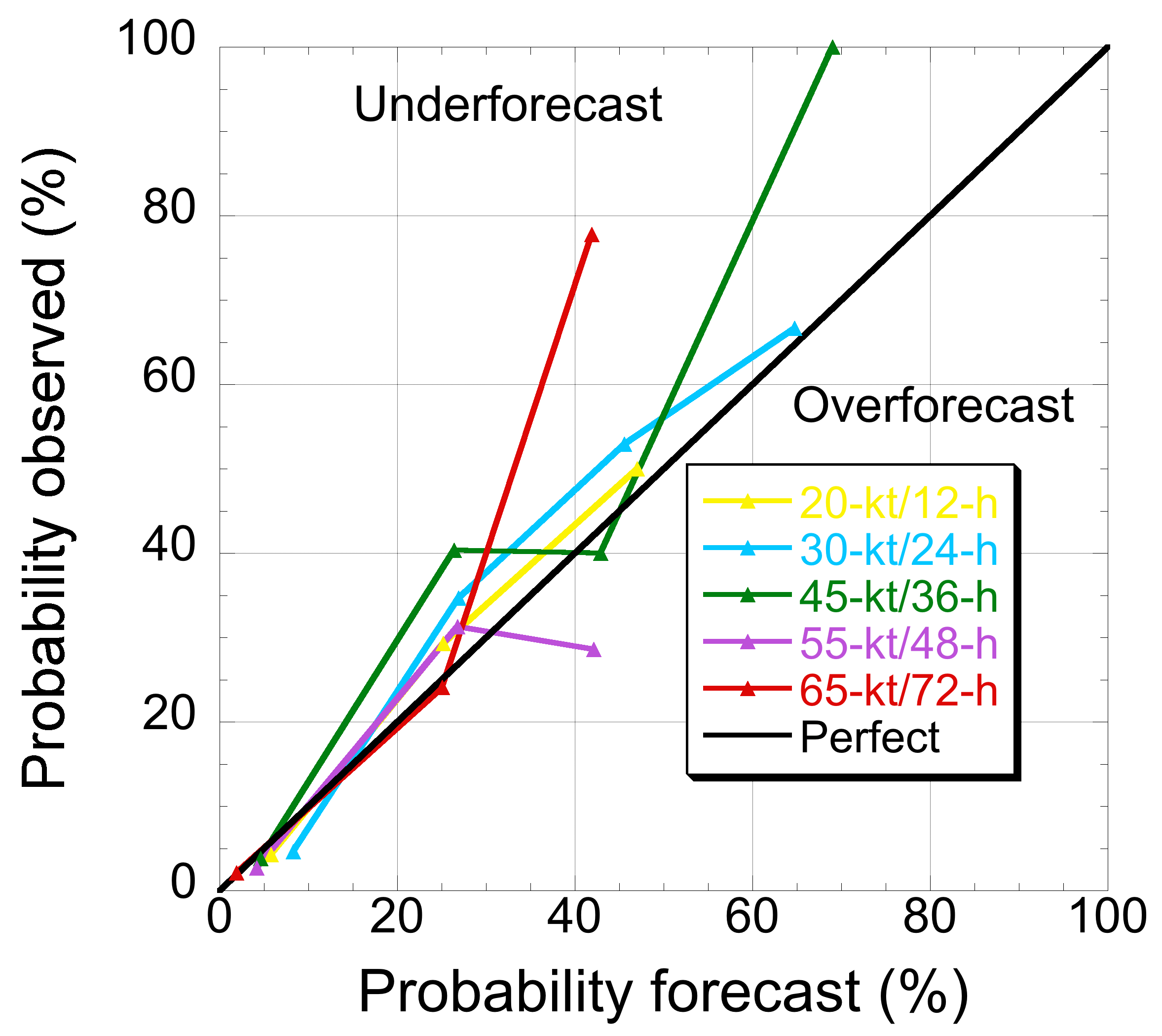
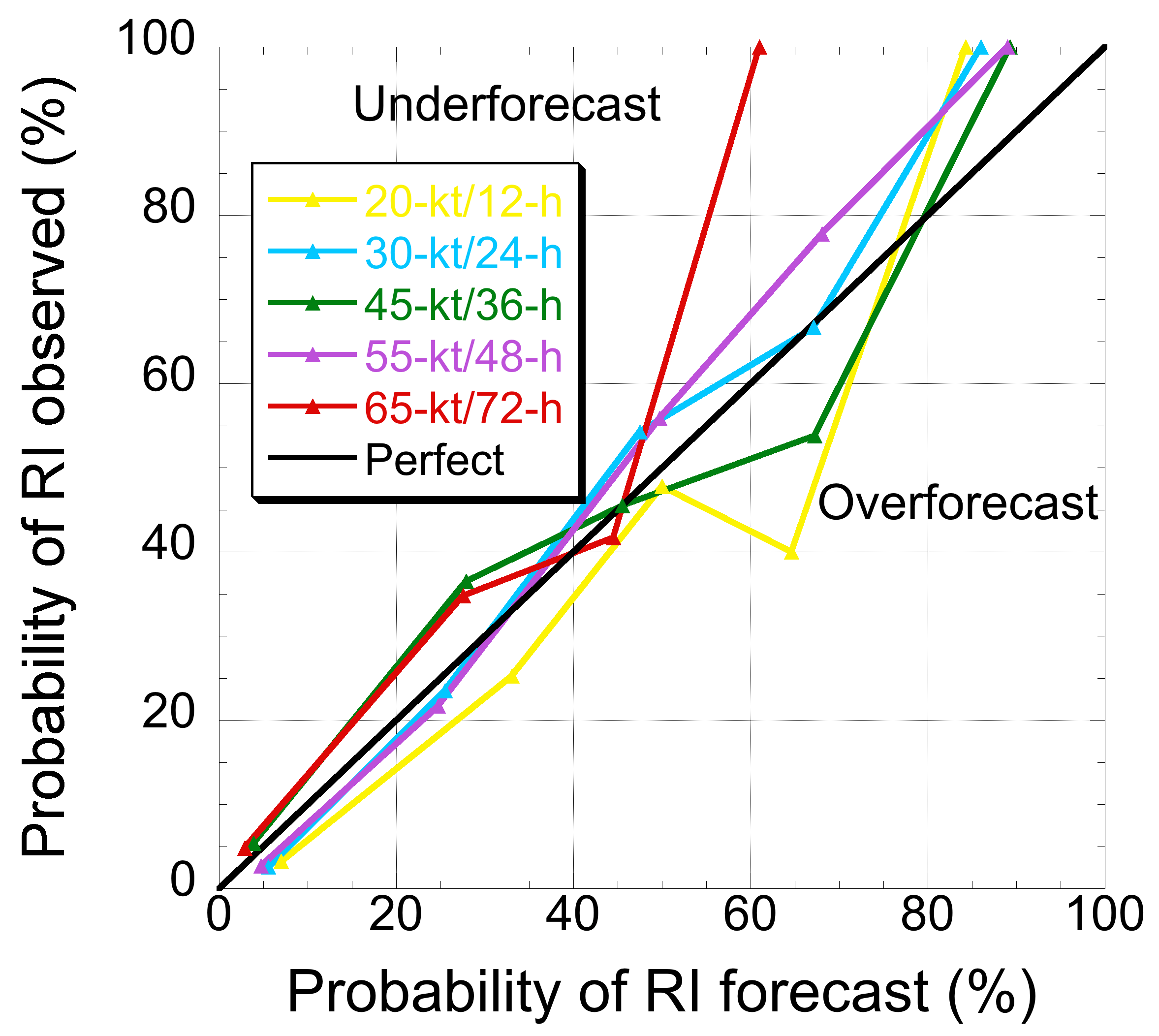
Fig. 2. Reliability diagrams depicting the forecasted versus observed probability of RI of the 2016-2019 operational SHIPS-RII forecasts for the 20-kt/12-h (yellow line), 30-kt/24-h (blue line) , 45-kt/36-h (green line), 55-kt/48-h (purple line) and 65-kt/72-h (red line) rapid intensification thresholds. Separate reliability diagrams are shown for the Atlantic (left panel) and central/Eastern North Pacific basin (right panel. The diagonal black line depicted on both panels indicates perfect reliability. Image Credit: NOAA AOML.
Michael (2018) Forecasts
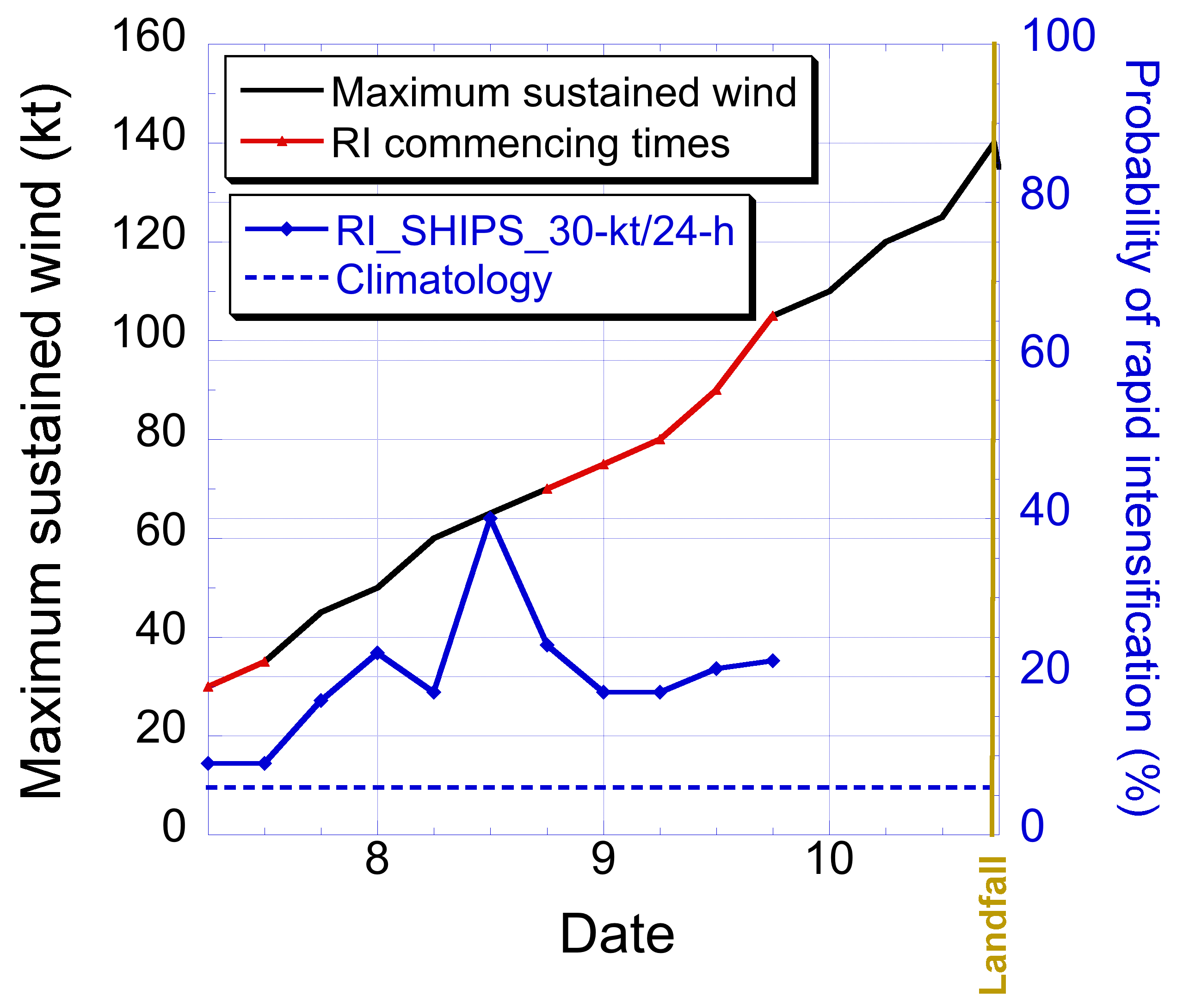
Figure 3 provides an example of the operational SHIPS-RII forecasts for the 30-kt/24h rapid intensification threshold for Hurricane Michael (2018). It can be seen that the SHIPS-RII forecasted probabilities were elevated relative to those of climatology for the entire forecast period but were highest just prior to Michael’s initial period of rapid intensification. However, the SHIPS-RII probabilities were only modestly higher than climatology during the latter period of rapid intensification that Michael underwent just prior to making landfall along the Florida panhandle underscoring the limitations of the model.
Our Data
Below is a link to our data page, which offers a wealth of storm-centered and global model data. We provide global and storm centered “nest” plots, which include the HWRF and HWRF-B models. A combination of the model guidance is essential to have a holistic view of active storms and weather patterns. Each model delivers a suite of data around six-hour increments, which covers winds at different levels of the atmosphere and various types of precipitation. Our data page also contains archives for model runs of different storms in the Northeast Pacific and Atlantic basins.

Supporting the Hurricane Field Program
The numerical modeling group supports the NOAA Hurricane Field Program by delivering experimental hurricane forecasts to HRD scientists, who play a pivotal role in planning aircraft missions. For example, the Hurricane Analysis and Forecast System (HAFS) provides planners with high resolution forecasts across the entire North Atlantic basin and the Basin-scale HWRF (HWRF-B) provides an alternative option to the operational HWRF. These experimental models can also help determine what data types or regions to target in missions through research and data sensitivity studies.

Key Accomplishments
Transitions start from HWRF to FV3-based HAFS system.
2019
HWRF versions incorporated into NCEP Operations.
Incorporated a further increment of the horizontal resolution, from 18/6/2 km to 13.5/4.5/1.5 km
2018
Implementation of the improved HWRF Data Assimilation system
2017
Five-Year Improvements Mark: New SAS and GFS-EDMF physics suites were implemented
2016
Sundararaman Gopalakrishnan, Thiago Quirino, and Frank Marks awarded the Department of Commerce Gold Medal and for Xuejin Zhang, a CIMAS Gold Medal for scientific excellence for developing and implementing the high-resolution HWRF model.
Increased horizontal resolution from 27/9/3 km to 18/6/2 km across all domains.
2015
South Florida Federal Executive Board- Scientific Employee of the Year.
HWRF was run in real-time in all global basins beyond the North Atlantic.
2014
Operational assimilation of Doppler Radar data from NOAA P-3s into HWRF model.
Double-nested, cloud-resolving version of HWRF was run for the first time at 3 km horizontal resolution with improved physics based on observations.
OAR Scientific Employee of the Year.
Upgraded physics and vortex initialization were adopted.
2013
Nominated for the South Florida Federal Executive Board’s Employee of the Year Award in the Scientific Category.
Certificate of Appreciation for contributions in developing the Advanced HWRF High-Resolution model.
Received NOAA Administrator’s Award.
2012
Multi-nested, High-Resolution HWRF becomes an official operational model.
Increased horizontal resolution from double-nested from 27/9 to 27/9/3, making HWRF the first-ever highest-resolution model running in operation for hurricane predictions.
Received Verner E. Suomi Award from the American Meteorological Society.
2011
Received NOAA/OAR Outstanding Scientific Paper Award
2010
NOAA’s HWRF model is officially adopted by the National Hurricane Center as one of its primary numerical guidance models
2007
NOAA’s HWRF modeling system is developed by the National Centers for Environmental Prediction specifically for hurricane forecasting.
2006
Who We Are


Acknowledgements
With much gratitude, AOML’s Hurricane Modeling Group acknowledges the vital scientific and executive support that it has received from NOAA and AOML’s upper-management since its inception. The support of Dr. Frank Marks, director of the Hurricane Research Division at AOML, and Dr. Robert Atlas, former director of AOML, has been crucial in the group’s quest to fulfill one of NOAA’s axiomatic goals: to improve hurricane track, structure, and intensity predictions by advancing NOAA’s HWRF modeling system.

A Community Model
Over the past decade, we have collaborated closely with the Environmental Modeling Center, Developmental Testbed Center, and the National Hurricane Center to develop and improve the operational HWRF model. This partnership allows HWRF to be used by both forecasters and researchers for operational and experimental purposes.
Featured Publication

Chen, X., Hazelton, A., Marks, F. D., Alaka Jr, G. J., & Zhang, C. (2023). Performance of an Improved TKE-Based Eddy-Diffusivity Mass-Flux (EDMF) PBL Scheme in 2021 Hurricane Forecasts from the Hurricane Analysis and Forecast System. Weather and Forecasting, 38(2), 321-336.
Abstract: Continuous development and evaluation of planetary boundary layer (PBL) parameterizations in hurricane conditions are crucial for improving tropical cyclone (TC) forecasts. A turbulence kinetic energy (TKE)-based eddy-diffusivity mass-flux (EDMF-TKE) PBL scheme, implemented in NOAA’s Hurricane Analysis and Forecast System (HAFS), was recently improved in hurricane conditions using large-eddy simulations. This study evaluates the performance of HAFS TC forecasts with the original (experiment HAFA) and modified EDMF-TKE (experiment HAFY) based on a large sample of cases during the 2021 North Atlantic hurricane season…
Performance of an Improved TKE-Based Eddy-Diffusivity Mass-Flux (EDMF) PBL Scheme in 2021 Hurricane Forecasts from the Hurricane Analysis and Forecast System
Chen, X., Hazelton, A., Marks, F. D., Alaka Jr, G. J., & Zhang, C. (2023). Performance of an Improved TKE-Based Eddy-Diffusivity Mass-Flux (EDMF) PBL Scheme in 2021 Hurricane Forecasts from the Hurricane Analysis and Forecast System. Weather and Forecasting, 38(2), 321-336.
Abstract: Continuous development and evaluation of planetary boundary layer (PBL) parameterizations in hurricane conditions are crucial for improving tropical cyclone (TC) forecasts. A turbulence kinetic energy (TKE)-based eddy-diffusivity mass-flux (EDMF-TKE) PBL scheme, implemented in NOAA’s Hurricane Analysis and Forecast System (HAFS), was recently improved in hurricane conditions using large-eddy simulations. This study evaluates the performance of HAFS TC forecasts with the original (experiment HAFA) and modified EDMF-TKE (experiment HAFY) based on a large sample of cases during the 2021 North Atlantic hurricane season…

Publications & References
2018
Kieu, C., K. Keshavamurthy, V. Tallapragada, S. Gopalakrishnan, and S. Trahan (2018): On the growth of intensity forecast errors in the operational hurricane weather research and forecasting (HWRF) model. Quarterly Journal of the Royal Meteorological Soc.144:1803–1819. https://doi.org/10.1002/qj.3344.Leighton, H., S. Gopalakrishnan, J.A. Zhang, R.F. Rogers, Z. Zhang, and V. Tallapragada (2018): Azimuthal distribution of deep convection, environmental factors and tropical cyclone rapid intensification: A perspective from HWRF ensemble forecasts of Hurricane Edouard (2014). Journal of the Atmospheric Sciences, 75(1):275-295. https://doi.org/10.1175/JAS-D-17-0171.1.
Zhang, J.A., F.D. Marks, J.A. Sippel, R.F. Rogers, X. Zhang, S.G. Gopalakrishnan, Z. Zhang, and V. Tallapragada (2018): Evaluating the Impact of Improvement in the Horizontal Diffusion Parameterization on Hurricane Prediction in the Operational Hurricane Weather Research and Forecast (HWRF) Model. Weather and Forecasting, 33, 317–329. https://doi.org/10.1175/WAF-D-17-0097.1.
2017
Alaka, G. J., X. Zhang, S. G. Gopalakrishnan, S. B. Goldenberg, and F. D. Marks, 2017: Performance of basin-scale HWRF tropical cyclone track forecasts. Wea. Forecast., 32(3):1253-1271, doi:10.1175/WAF-D-16-0150.1.Goldenberg, S., S. Gopalakrishnan, V. Tallapragada, T. Quirino, F. Marks, S. Trahan, X. Zhang, and R. Atlas, 2015: The 2012 triply-nested, high-resolution operational version of the hurricane weather research and forecasting system (HWRF): Track and intensity forecast verifications. Wea. Forecast., doi: 10.1175/WAF-D-14-00098.1.
2016
Gopalakrishnan, S., C.V. Srinavas, and K. Bhatia. The hurricane boundary layer. In Advanced Numerical Modeling and Data Assimilation Techniques for Tropical Cyclone Predictions, U.C. Mohanty and S.G. Gopalakrishnan (eds.). Springer Netherlands, 589-626, doi:10.1007/978-94-024-0896-6 2016Gopalakrishnan, F. Toepfer, R. Gall, F. Marks, E. N. Rappaport, V. Tallapragada, S. Forsythe-Newell, A. Aksoy, J. W. Bao, M. Bender, L. Bernardet, J. Cione, M. Biswas, J. Cangialosi, M. DeMaria, M.Morin,J. Doyle, J. L. Franklin, S. Goldenberg, George Halliwell, C. Holt, S. Jason, H. S. Kim, P. Kucera, N. Lett, P. McCaslin, A. Mehra, M. Mills, J. Moskaitis, A. Sergio, J. Sippel, S. Trahan, H. Tolman, R. Torn, X. Wang, J. Whitaker, D. A. Zelinsky, F. Zhang, X. Zhang, Z. Zhang, 2015 HFIP R&D Activities Summary: Recent Results and Operational Implementation, 2016 (http://www.hfip.org/documents/HFIP_AnnualReport_FY2015.pdf)
Quirino, T., and S.G. Gopalakrishnan. Advanced diagnostics for the HWRF hurricane modeling system. In Advanced Numerical Modeling and Data Assimilation Techniques for Tropical Cyclone Predictions, U.C. Mohanty and S.G. Gopalakrishnan (eds.). Springer Netherlands, 517-534, doi:10.1007/978-94-024-0896-6 2016
Mohanty, U.C., and S.G. Gopalakrishnan (eds.). Advanced Numerical Modeling and Data Assimilation Techniques for Tropical Cyclone Predictions. Springer Netherlands, 746 pp., doi:10.1007/978-94-024-0896-6 2016
Zhang, X., S.G. Gopalakrishnan, S. Trahan, T.S. Quirino, Q. Liu, Z. Zhang, G. Alaka, and and V. Tallapragada. Representing multiple scales in the Hurricane Weather Research and Forecasting modeling system: Design of multiple sets of movable multilevel nesting and the basin-scale HWRF forecast verification. Weather and Forecasting, 31(6):2019-2034, doi:10.1175/WAF-D-16-0087.1 2016
2015
Atlas, R., V. Tallapragada, and S. Gopalakrishnan. Advances in tropical cyclone intensity forecasts. Marine Technology Society Journal, 49(6):149-160, doi:10.4031/MTSJ.49.6.2 2015Bernardet, L., V. Tallapragada, S. Bao, S. Trahan, Y. Kwon, Q. Liu, M. Tong, M. Biswas, T. Brown, D. Stark, L. Carson, R. Yablonsky, E. Uhlhorn, S. Gopalakrishnan, X. Zhang, T. Marchok, B. Kuo, and R. Gall. Community support and transition of research to operations for the Hurricane Weather Research and Forecasting model. Bulletin of the American Meteorological Society, 96(6):953-960, doi:10.1175/BAMS-D-13-00093.1 2015
Chen, H., and S.G. Gopalakrishnan. A study on the asymmetric rapid intensification of Hurricane Earl (2010) using the HWRF system. Journal of the Atmospheric Sciences, 72(2):531-550, doi:10.1175/JAS-D-14-0097.1 2015
Goldenberg, S.B., S.G. Gopalakrishnan, V. Tallapragada, T. Quirino, F. Marks, S. Trahan, X. Zhang, and R. Atlas. The 2012 triply-nested, high-resolution operational version of the Hurricane Weather Research and Forecasting System (HWRF): Track and intensity forecast verifications. Weather and Forecasting, 30(3):710-729, doi:10.1175/WAF-D-14-00098.1 2015
Halliwell, G.R., S. Gopalakrishnan, F. Marks, and D. Willey. Idealized study of ocean impacts on tropical cyclone intensity forecasts. Monthly Weather Review, 143(4):1142-1165, doi:10.1175/MWR-D-14-00022.1 2015
Quirino, T.S., J. Delgado, and X. Zhang. Improving the scalability of a hurricane forecast system in mixed-parallel environments. Proceedings, 16th IEEE International Conference on High Performance Computing and Communications, Paris, France, August 20-22, 2014. IEEE Computer Society, 276-281, 2015
Zhang, D.-L., L. Zhu, X. Zhang, and V. Tallapragada. Sensitivity of idealized hurricane intensity and structures under varying background flows and initial vortex intensities to different vertical resolutions in HWRF. Monthly Weather Review, 143(3):914-932, doi:10.1175/MWR-D-14-00102.1 2015
Zhu, P., Z. Zhu, S. Gopalakrishnan, R. Black, F.D. Marks, V. Tallapragada, J.A. Zhang, X. Zhang, and C. Gao. Impact of sub-grid scale processes on eyewall replacement cycle of tropical cyclones in HWRF system. Geophysical Research Letters, 42(22):10027-10036, doi:10.1002/2015GL066436 2015
2014
Gall, R., F. Toepfer, F. Marks, E.N. Rappaport, A. Aksoy, S. Aberson, J.W. Bao, M. Bender, S. Benjamin, L. Bernardet, M. Biswas, B. Brown, J. Cangialosi, C. Davis, M. DeMaria, J. Doyle, M. Fiorino, J. Franklin, I. Ginis, S. Gopalakrishnan, T. Hamill, R. Hodur, H.S. Kim, J. Knaff, T. Krishnamurti, P. Kucera, Y. Kwon, W. Lapenta, N. Lett, S. Lord, T. Marchok, E. Mifflin, M. Morin, K. Musgrave, L. Nance, C. Reynolds, V. Tallapragada, H. Tolman, R. Torn, G. Vandenberghe, T. Vukicevic, X. Wang, Y. Weng, J. Whittaker, R. Yablonsky, D.-L. Zhang, F. Zhang, J. Zhang, X. Zhang, and D.A. Delinsky. Hurricane Forecast Improvement Project: 2013 HFIP R&D activities summary—Recent results and operational implementation. HFIP Technical Report, HFIP2014-2, 50 pp., 2014Pattanayak, S., U.C. Mohanty, and S.G. Gopalakrishnan. Improvement in track and intensity prediction of Indian seas tropical cyclones with vortex assimilation. In Monitoring and Prediction of Tropical Cyclones in the Indian Ocean and Climate Change, U.C. Mohanty, M. Mohapatra, O.P. Singh, B.K. Bandyopadhyay, and L.S. Rathore (eds.). Springer Publishing, 219-229, doi:10.1007/978-94-007-7720-0 2014
2013
Gopalakrishnan, S.G., F. Marks, J.A. Zhang, X. Zhang, J.-W. Bao, and V. Tallapragada. A study of the impacts of vertical diffusion on the structure and intensity of tropical cyclones using the high resolution HWRF system. Journal of the Atmospheric Sciences, 70(2):524-541, doi:10.1175/JAS-D-11-0340.1 2013Rogers, R.F., S.D. Aberson, A. Aksoy, B. Annane, M. Black, J.J. Cione, N. Dorst, J. Dunion, J.F. Gamache, S.B. Goldenberg, S.G. Gopalakrishnan, J. Kaplan, B.W. Klotz, S. Lorsolo, F.D. Marks, S.T. Murillo, M.D. Powell, P.D. Reasor, K.J. Sellwood, E.W. Uhlhorn, T. Vukicevic, J.A. Zhang, and X. Zhang. NOAA’s Hurricane Intensity Forecasting Experiment (IFEX): A progress report. Bulletin of the American Meteorological Society, 94(6):859-882, doi:10.1175/BAMS-D-12-00089 2013
2012
Bao, J.-W., S.G. GOPALAKRISHNAN, S.A. Michelson, F.D. Marks, and M.T. Montgomery, 2012: Impact of physics representations in the HWRF model on simulated hurricane structure and wind-pressure relationships. Monthly Weather Review, 140(10):3278-3299 (doi:10.1175/MWR-D-11-00332.1).Bell, G.D., E.S. Blake, C.W. Landsea, T.B. Kimberlain, S.B. GOLDENBERG, J. Schemm, and R.J. Pasch, 2012: The tropics: Atlantic basin. In State of the Climate in 2011, J. Blunden and D.S. Arndt (eds.). Bulletin of the American Meteorological Society, 93(7):S99-S105.
BLACK, R.A., and J. Hallett, 2012: Rain rate and water content in hurricanes compared with summer rain in Miami, Florida. Journal of Applied Meteorology and Climatology, 51(12):2218-2235 (doi:10.1175/JAMC-D-11-0144.1).
GOPALAKRISHNAN, S.G., S. GOLDENBERG, T. QUIRINO, F. Marks, X. ZHANG, K.-S. Yeh, R. Atlas, and V. Tallapragada, 2012: Towards improving high-resolution numerical hurricane forecasting: Influence of model horizontal grid resolution, initialization, and physics. Weather and Forecasting, 27(3):647-666 (doi:10.1175/WAF-D-11-00055.1).
Laureano-Bozeman, M., D. Niyogi, S. GOPALAKRISHNAN, F.D. Marks, X. ZHANG, and V. Tallapragada, 2012: An HWRF-based ensemble assessment of the land surface feedback on the post-landfall intensification of Tropical Storm Fay (2008). Natural Hazards, 63(3):1543-1571 (doi:10.1007/s11069-011-9841-5).
Pattanayak, S., U.C. Mohanty, and S.G. GOPALAKRISHNAN, 2012: Simulation of very severe cyclone Mala over Bay of Bengal with HWRF modeling system. Natural Hazards, 63(3):1413-1437 (doi:10.1007/s11069-011-9863-z).
Yeh, K.-S., X. ZHANG, S.G. GOPALAKRISHNAN, S. Aberson, R. Rogers, F.D. Marks, and R. Atlas, 2012: Performance of the experimental HWRF in the 2008 hurricane season. Natural Hazards, 63(3):1439-1449 (doi:10.1007/s11069-011-9787-7).
Prior to 2012
2011
Bell, G.D., E.S. Blake, T.B. Kimberlain, C.W. Landsea, J. Schemm, R.J. Pasch, and S.B. GOLDENBERG, 2011: The tropics: Atlantic basin. In State of the Climate in 2010, J. Blunden, D.S. Arndt, and M.O. Baringer (eds.). Bulletin of the American Meteorological Society, 92(6):S115-S121 (doi:10.1175/1520-0477-92.6.S1).
GOPALAKRISHNAN, S.G., F. Marks, X. ZHANG, J.-W. Bao, K.-S. Yeh, and R. Atlas, 2011: The Experimental HWRF system: A study on the influence of horizontal resolution on the structure and intensity changes in tropical cyclones using an idealized framework. Monthly Weather Review, 139(6):1762-1784 (doi:10.1175/ 2010MWR3535.1).
ZHANG, X., T.S. QUIRINO, K.-S. Yeh, S.G. GOPALAKRISHNAN, F.D. Marks, S.B. GOLDENBERG, and S. Aberson, 2011: HWRFx: Improving hurricane forecasts with high-resolution modeling. Computing in Science and Engineering, 13(1):13-21 (doi:10.1109/MCSE.2010.121).
2010
Bell, G.D., E.S. Blake, T.B. Kimberlain, C.W. Landsea, R.J. Pasch, J. Schemm, and S.B. GOLDENBERG, 2010: Atlantic basin. In State of the Climate in 2009, D.S. Arndt. M.O. Baringer, and M.R. Johnson (eds.). Bulletin of the American Meteorological Society, 91(7):84-88.
2009
Bell, G.D., E. Blake, S.B. GOLDENBERG, T. Kimberlain, C.W. Landsea, R. Pasch, and J. Schemm, 2009: Tropical cyclones: Atlantic basin. In State of the Climate in 2008, T.C. Peterson and M.O. Baringer (eds.). Bulletin of the American Meteorological Society, 90(8):S79-S83.
Panda, J., M. Sharan, and S.G. GOPALAKRISHNAN, 2009: Study of regional-scale boundary layer characteristics over northern India with a special reference to the role of the Thar Desert in regional-scale transport. Journal of Applied Meteorology and Climatology, 48(11):2377-2402.
2008
Bell, G.D., E. Blake, C.W. Landsea, S.B. GOLDENBERG, R. Pasch, and T. Kimberlain, 2008: The tropics: Atlantic basin. In State of the Climate in 2007, D.H. Levinson and J.H. Lawrimore (eds.). Bulletin of the American Meteorological Society, 89(7):S68-S71.
Looking for Literature? Search our Publication Database.