Introduction
Tropical cyclones feed off of the energy from the warm ocean below; they have only very small changes in temperature, and the environmental wind around the system is similar from its top to bottom (low wind shear). As they move out of the Tropics, they may encounter large changes in temperature, increasing wind shear and decreasing sea surface temperature which causes them to undergo a process known as Extratropical Transition.
Understanding Storm Structure & Evolution Improves Weather Forecasts
Hurricanes and tropical storms are complex phenomena that can grow and change as they move out of the tropics. The factors that influence storms, such as temperature, wind shear, and humidity can dictate those changes and change rapidly. We work to better understand the evolution of storms in order to improve forecasts and help minimize damage to life and property when storms do make landfall.
Extratropical Transition can Lead to Decay or Rapid Intensification
These systems may produce intense rainfall, large waves, and hurricane-force winds, but the Extratropical Transition process remains poorly understood and forecast. Significant gaps exist in understanding changes in storm structure and in the forecasting of the ultimate outcome of Extratropical Transition – whether the system will decay or even rapidly intensify into a large and powerful extratopical cyclone. In order to improve our understanding and forecasting of these events, targeted sampling of tropical cyclones undergoing Extratropical Transition are being made both with existing and new observing techniques.
Creating A Weather-Ready Nation
With Storm Transition Research
Extratropical Transition can produce dangerous conditions, but not much is understood about how a storm transitions. This lack of understanding can result in poor forecasts. Our goal is to complete analyses of cases in which airborne data have been gathered and to use our new knowledge to improve the accuracy of these forecasts. To see our Extratropical Transition stories, visit the HRD Blog.
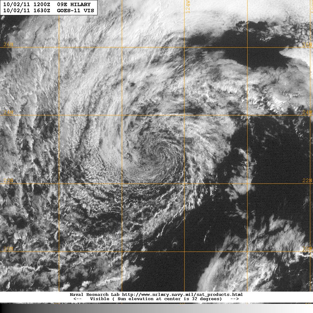 Remnant of Hillary after Reaching Cold Surface Water
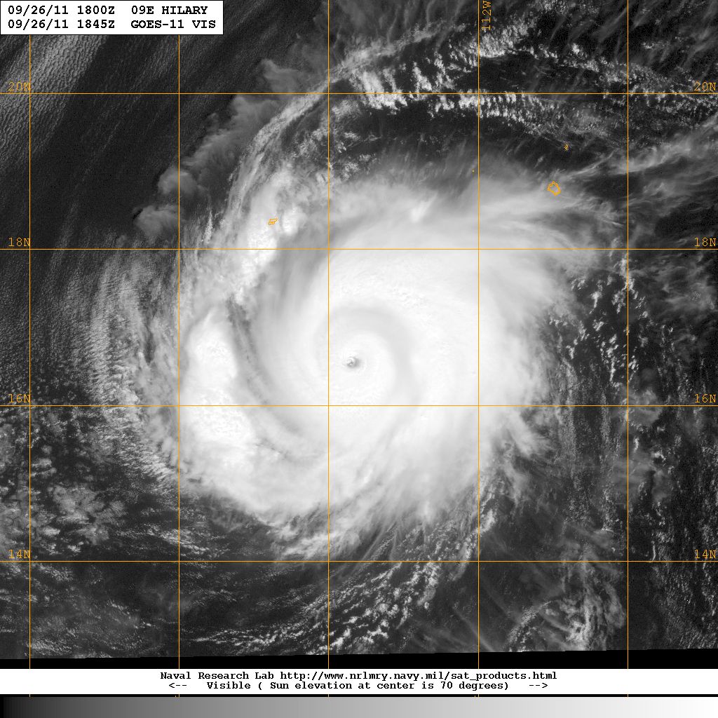 Category 4 Hurricane Hilary
In Situ Sampling
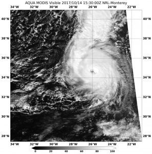
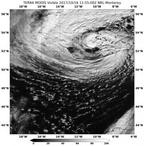
As part of HRD’s Intensity Forecasting Experiment, we have undertaken a concerted effort to sample tropical cyclones undergoing Extratropical Transition with research aircraft. Five Atlantic tropical cyclones have been sampled (Hurricanes Earl in 2010, Tomas in 2010, Sandy in 2012, Arthur in 2014 and Tropical Storm Karl in 2016). In addition, the NOAA P3 aircraft sampled two East Pacific Hurricanes (Patricia in 2015 and Hilary in 2011) before and during their weakening phases as they encountered strong vertical wind shear and a region of cold sea surface temperature, respectively.

What we Know about Extratropical Transition

Hazelton, A., Zhang, Z., Liu, B., Dong, J., Alaka, G., Wang, W., … & Marks, F. (2021). 2019 Atlantic hurricane forecasts from the global-nested hurricane analysis and forecast system: Composite statistics and key events. Weather and Forecasting, 36(2), 519-538.
Abstract: NOAA’s Hurricane Analysis and Forecast System (HAFS) is an evolving FV3-based hurricane modeling system that is expected to replace the operational hurricane models at the National Weather Service. Supported by the Hurricane Forecast Improvement Program (HFIP), global-nested and regional versions of HAFS were run in real time in 2019 to create the first baseline for the HAFS advancement. In this study, forecasts from the global-nested configuration of HAFS (HAFS-global nest) are evaluated and compared with other operational and experimental models. The forecasts by HAFS-global nest covered the period from July through October during the 2019 hurricane season. Tropical cyclone (TC) track, intensity, and structure forecast verifications are examined…
2019 Atlantic Hurricane Forecasts from the Global-Nested Hurricane Analysis and Forecast System: Composite Statistics and Key Events
Hazelton, A., Zhang, Z., Liu, B., Dong, J., Alaka, G., Wang, W., … & Marks, F. (2021). 2019 Atlantic hurricane forecasts from the global-nested hurricane analysis and forecast system: Composite statistics and key events. Weather and Forecasting, 36(2), 519-538.
Abstract: NOAA’s Hurricane Analysis and Forecast System (HAFS) is an evolving FV3-based hurricane modeling system that is expected to replace the operational hurricane models at the National Weather Service. Supported by the Hurricane Forecast Improvement Program (HFIP), global-nested and regional versions of HAFS were run in real time in 2019 to create the first baseline for the HAFS advancement. In this study, forecasts from the global-nested configuration of HAFS (HAFS-global nest) are evaluated and compared with other operational and experimental models. The forecasts by HAFS-global nest covered the period from July through October during the 2019 hurricane season. Tropical cyclone (TC) track, intensity, and structure forecast verifications are examined…

Atlantic Hurricanes
East Pacific Hurricanes

| Sim D. Aberson, Ph.D.
Principal Investigator
If you would like more information on the this project, please contact Sim Aberson, Principal Investigator of this project.