Dynamics and Physics
Understanding Tropical Cyclone Structure and Intensity
SCROLL TO LEARN MORE
Who We Are
The destructive potential of a hurricane is governed by its interaction with the environment and physical processes internal to the storm. Researchers at AOML use a variety of tools to better understand how phenomena from the larger environmental scale down to the cloud and turbulent scale interact (multi-scale interactions) to produce such changes.
We also work closely with scientists from other disciplines to improve the tools available and to apply a new understanding in a way that benefits prediction and improves forecasts.
Objective
Our Objective is to improve our understanding of tropical cyclone structure and intensity change through the application of fundamental physical principles.


Top News
Subsurface biogeochemical response to Hurricane Idalia within a cyclonic eddy and river plume–stratified environment
March 2, 2026
Jennifer K. McWhorter, Lev B. Looney, et al.
Satellite observations can reveal chlorophyll blooms in the wake of hurricane disturbances but their subsurface biogeochemical anomalies remain poorly described due to limited in situ observations. Here, we quantify the biogeochemical response across the ocean water column to Hurricane Idalia (2023) in the Gulf of America (also known as the Gulf of America). We compile observations across the eastern Gulf using satellite data and two autonomous platforms: a profiling Biogeochemical-Argo (BGC-Argo) float and saildrone. Prior to the formation of Hurricane Idalia, an anomalously large extension of the Mississippi River plume spanned much of the eastern Gulf, contributing low-salinity and high-chlorophyll conditions. Following Idalia’s passage, the saildrone observed surface chlorophyll increases in the river plume extension, while the BGC-Argo float observed subsurface nitrate depletion and oxygen enrichment. These changes occurred as the float measured background ocean conditions evolving from the edge of the Loop Current to a cyclonic eddy, influenced by the river plume extension. Increases in chlorophyll concentration, decreases in nitrate, and elevated dissolved oxygen levels suggested increased primary production. BGC-Argo float observations revealed enhanced upwelling below the surface layer (~22 m) that shoaled the nitracline, fueling the increase in subsurface primary production (20–50 m depth). Our study provides a glimpse on the surface and subsurface ocean-biogeochemical changes associated with the Hurricane Idalia passage, highlighting the importance of the background mesoscale seascape on shaping the phytoplankton response to hurricane-induced disturbances. The combination of observations underscores the value of continuous in situ monitoring to better understand hurricane-driven impacts on the full ocean water column and the impacts these dynamics have on the base of the marine food web.


Read More News
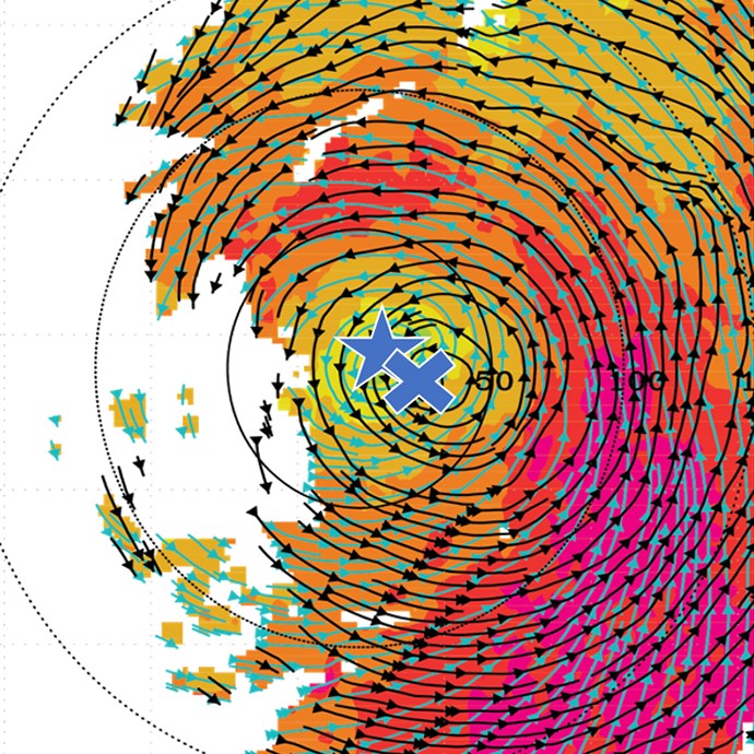
Components of the Multi-Scale Interaction
Storm Environment
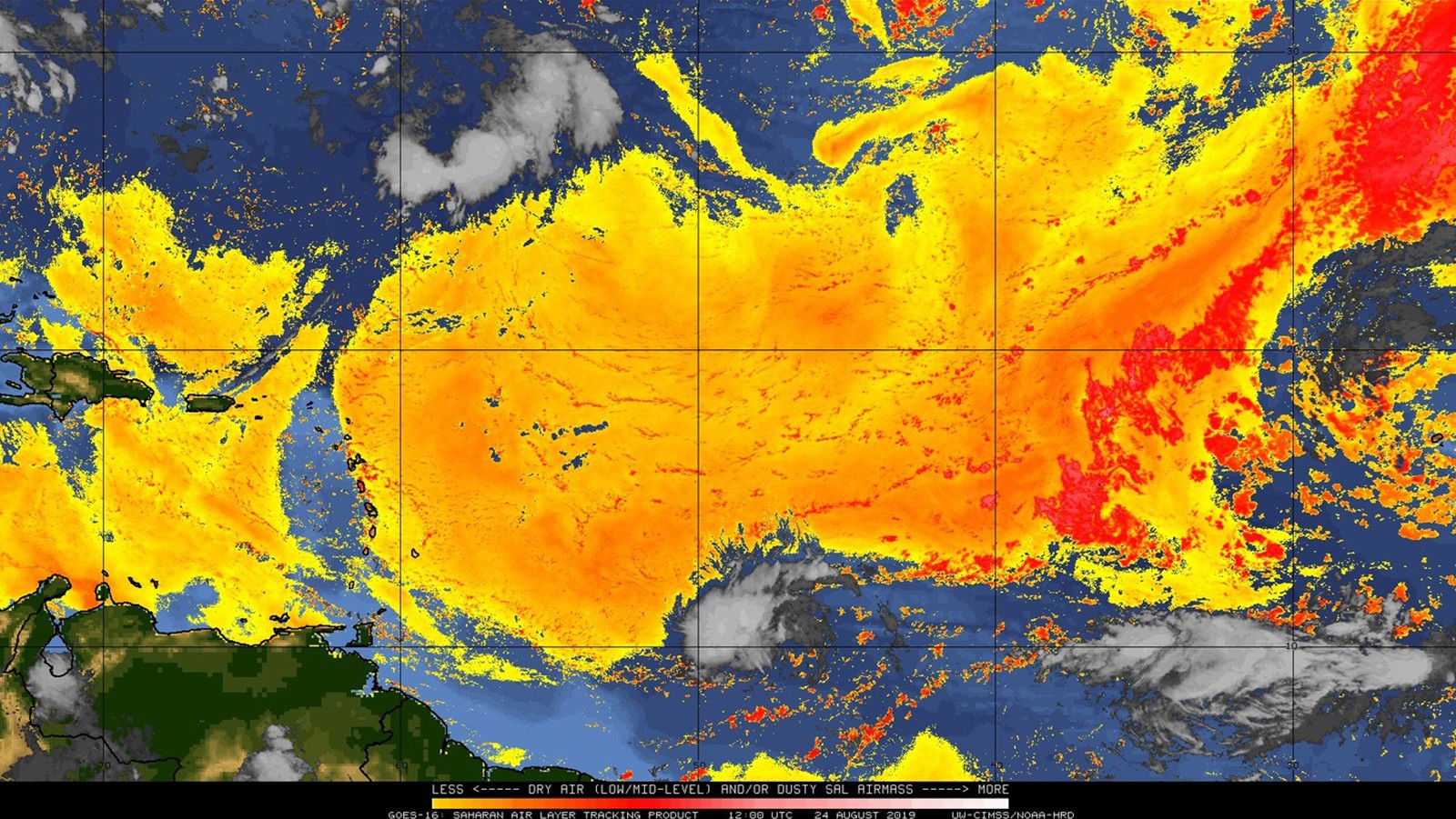
A hurricane develops within an atmosphere characterized by evolving larger-scale distributions of moisture and wind, and over an ocean with a more slowly-evolving distribution of temperature. The surrounding atmosphere and ocean below a hurricane is called
the storm environment. Because the storm environment interacts with the hurricane, it is important both to characterize and understand it.
Storm-Environment Interactions
The interaction between a tropical cyclone (whether a hurricane, tropical storm, tropical depression, or a pre-depression) and the environment it encounters plays a critical role in determining whether the storm structure and intensity will change.
Internal Storm Processes
These are physical processes that can operate independently of the storm’s environment, or “internally.” Among other impacts, they are often associated with dramatic short-term changes in storm size and intensity, and are responsible for intense localized winds.
Building a Weather-Ready Nation.
Understanding Hurricane Formation.
Read “Precipitation Processes and Vortex Alignment during the Intensification of a Weak Tropical Cyclone in Moderate Vertical Shear.”
Understanding the formation of a hurricane is critical to preparing coastal communities before severe weather threatens our coasts. Our scientists are studying this question by looking at how these weather patterns change and mature in their environment from small to large scales. Read the latest research below.
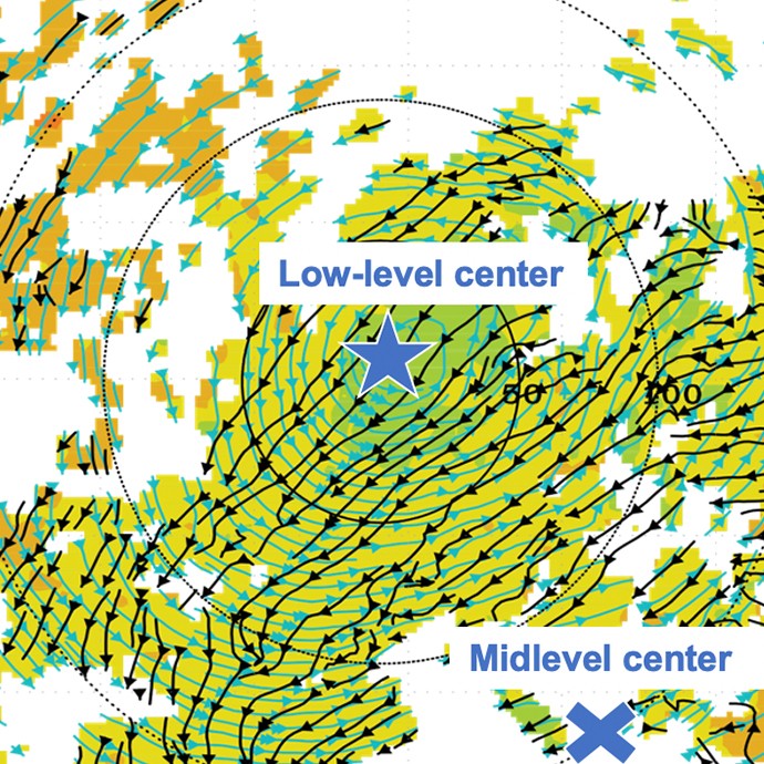
Vortex Alignment
Storms struggle to intensify when their circulations are not aligned between the lower and upper levels of the atmosphere, which often happens when they encounter vertical wind shear. AOML hurricane scientists investigate how these storms can become aligned and intensify, even in the presence of this hostile wind environment.
Precipitation Processes
The structure of precipitation (rainfall) and how it’s distributed around the storm can play an important role in determining whether or not the storm will intensify. Scientists at AOML investigate how the structure and distribution of precipitation changes in relation to the storm environment to allow for intensification.
Planetary Boundary Layer Recovery
Precipitation can bring cool, dry air to the boundary layer, effectively limiting the development of strong thunderstorms in the storm circulation. Scientists at AOML study how the boundary layer can recover in the presence of vertical wind shear to allow for new development of thunderstorms and storm intensification.
Slide to look at aligned v. unaligned vortex

Secondary Eyewall Formation
Intense hurricanes often develop so-called secondary eyewalls outside of the initial primary eyewall. AOML hurricane scientists investigate how these secondary eyewalls form and their impact on hurricane intensity.

Eyewall Mixing
An otherwise circular eyewall can transition into a dynamic mixture of spiral bands and intense localized swirls. Hurricane scientists at AOML investigate how these smaller-scale structures impact hurricane intensification.

Planetary Boundary Layer Dynamics
The layer of the hurricane flow closest to the ocean surface is characterized by turbulent motion. AOML scientists study how the effects of turbulence can be represented in models that are unable to simulate the turbulent motions. They also study how the turbulence contributes to hurricane intensification.
Hurricane Field Program
We Drive Innovative Science.
Experimental Design and the Hurricane Field Program.
Addressing research questions about the dynamics and physics of tropical cyclones is a major factor in how in-flight observations are taken. Because we have a direct line to observations from the Hurricane Field Program, we can capitalize on using these data for cutting-edge hurricane genesis and intensification research.
Read the experimental design plans for the Hurricane Field Program to learn more.


DesRosiers, A. J., Bell, M. M., Klotzbach, P. J., Fischer, M. S., & Reasor, P. D. (2023). Observed relationships between tropical cyclone vortex height, intensity, and intensification rate. Geophysical Research Letters, 50(8), e2022GL101877.
Abstract: As a tropical cyclone (TC) intensifies, the tangential wind field expands vertically and increases in magnitude. Observations and modeling support vortex height as an important TC structural characteristic. The Tropical Cyclone Radar Archive of Doppler Analyses with Recentering data set provides kinematic analyses for calculation of the height of the vortex (HOV) in observed storms. Analyses are azimuthally-averaged with tangential wind values taken along the radius of maximum winds. A threshold-based technique is used to determine the HOV. A fixed threshold HOV strongly correlates with current intensity. A dynamic HOV metric quantifies vertical decay of tangential wind with reduced dependency on intensity. Statistically significant differences are present between dynamic HOV values in groups of steady-state, intensifying, and rapidly-intensifying cases categorized by subsequent changes in pressure.
Observed Relationships Between Tropical Cyclone Vortex Height, Intensity, and Intensification Rate
DesRosiers, A. J., Bell, M. M., Klotzbach, P. J., Fischer, M. S., & Reasor, P. D. (2023). Observed relationships between tropical cyclone vortex height, intensity, and intensification rate. Geophysical Research Letters, 50(8), e2022GL101877.
Abstract: As a tropical cyclone (TC) intensifies, the tangential wind field expands vertically and increases in magnitude. Observations and modeling support vortex height as an important TC structural characteristic. The Tropical Cyclone Radar Archive of Doppler Analyses with Recentering data set provides kinematic analyses for calculation of the height of the vortex (HOV) in observed storms. Analyses are azimuthally-averaged with tangential wind values taken along the radius of maximum winds. A threshold-based technique is used to determine the HOV. A fixed threshold HOV strongly correlates with current intensity. A dynamic HOV metric quantifies vertical decay of tangential wind with reduced dependency on intensity. Statistically significant differences are present between dynamic HOV values in groups of steady-state, intensifying, and rapidly-intensifying cases categorized by subsequent changes in pressure.

Publications & References
2024
Alford, A.A., B. Schenkel, S. Hernandez, J.A. Zhang, M.I. Biggerstaff, E. Blumenauer, T.N. Sandmæl, and S.M. Waugh. Examining outer band supercell environments in landfalling tropical cyclones using ground-based radar analyses. Monthly Weather Review, 152(10):2265-2285, https://doi.org/10.1175/MWR-D-23-0287.1 2024 FY2025Chen, X., and F.D. Marks. Parameterizations of boundary layer mass fluxes in high-wind conditions for tropical cyclone simulations. Journal of the Atmospheric Sciences, 81(1):77-91, https://doi.org/10.1175/JAS-D-23-0086.1 2024 FY2024
Fischer, M.S., R.F. Rogers, P.D. Reasor, and J.P. Dunion. An observational analysis of the relationship between tropical cyclone vortex tilt, precipitation structure, and intensity change. Monthly Weather Review, 152(1):203-225, https://doi.org/10.1175/MWR-D-23-0089.1 2024 FY2024
Kang, S.K., E.J. Kim, S. Kim, J. Cione, D. Lee, S. Landwehr, H.-W. Kang, K.-O. Kim, C.S. Hong, M.H. Kwon, K.H. Oh, J.H. Lee, S. Noh, J.K. So, D.-J. Kang, D. Kim, J.-H. Park, S. Nam, Y.K. Cho, B. Ward, and I. Ginis. Anomalously large latent heat fluxes in low to moderate wind conditions within the eddy-rich zone of the northwestern Pacific. Frontiers in Marine Science, 11:1298641, https://doi.org/10.3389/fmars.2024.1298641 2024 FY2024
Kang, S.K., S.-H. Kim, I.-I. Lin, Y.-H. Park, Y. Choi, I. Ginis, J. Cione, J.Y. Shin, E.J. Kim, K.O. Kim, H.W. Kang, J.-H. Park, J.-R. Bidlot, and B. Ward. The North Equatorial Current and rapid intensification of super typhoons. Nature Communications, 15:1742, https://doi.org/10.1038/s41467-024-45685-2 2024 FY2024
Lin, G., Z. Wang, Y.F. Chu, C.L. Ziegler, X.M. Hu, M. Xue, B. Geerts, S. Paleri, A.R. Desai, K. Yang, M. Deng, and J. Degraw. Airborne measurements of scale-dependent latent heat flux impacted by water vapor and vertical velocity over heterogeneous land surfaces during the CHEESEHEAD19 campaign. Journal of Geophysical Research-Atmospheres, 129(3):e2023JD039586, https://doi.org/10.1029/2023JD039586 2024 FY2024
Murray, E.J., J. Dunion, K.B. Karnauskus, Z. Wang, and J.A. Zhang. Cloud height distributions and the role of vertical mixing in the tropical cyclone eye derived from compact Raman lidar observations. Geophysical Research Letters, 51(14):e2024GL108515, https://doi.org/10.1029/2024GL108515 2024 FY2024
Rios-Berrios, R., P.M. Finocchio, J.J. Alland, X. Chen, M.S. Fischer, S.N. Stevenson, and D. Tao. A review of the interactions between tropical cyclones and environmental vertical wind shear. Journal of the Atmospheric Sciences, 81(4):713-741, https://doi.org/10.1175/JAS-S-23-0022.1 2024 FY2024
Rojas, B.S., A.C. Didlake Jr., and J.A. Zhang. Asymmetries during eyewall replacement cycles of Hurricane Ivan (2004). Monthly Weather Review, 152(8):1741-1761, https://doi.org/10.1175/MWR-D-23-0129.1 2024 FY2024
Shimada, U., P.D. Reasor, R.F. Rogers, M.S. Fischer, F.D. Marks, J.A. Zawislak, And J.A Zhang. Shear-relative asymmetric kinematic characteristics of intensifying hurricanes as observed by airborne Doppler radar Monthly Weather Review, 152(2):491-512, https://doi.org/10.1175/MWR-D-22-0340.1 2024 FY2024
Tang, B.H., R. Rios-Berrios, and J.A. Zhang. Diagnosing radial ventilation in dropsonde observations of Hurricane Sam (2021). Monthly Weather Review, 152(8):1725-1739, https://doi.org/10.1175/MWR-D-23-0224.1 2024 FY2024
Wang, W., J. Han, J. Shin, X. Chen, A. Hazelton, L. Zhu, H.-S. Kim, X. Li, B. Liu, Q. Liu, J. Steffen, R. Sun, W. Zheng, Z. Zhang, and F. Yang. Physics schemes in the first version of NCEP operational Hurricane Analysis and Forecast System (HAFS). Frontiers in Earth Science, 12:1379069, https://doi.org/10.3389/feart.2024.1379069 2024 FY2024
Zhao, B., L. Wu, G. Wang, J.A. Zhang, L. Liu, C. Zhao, Z. Zhuang, C. Xia, Y. Xue, X. Li, and F. Quao. A numerical study of tropical cyclone and ocean responses to air-sea momentum flux at high winds. Journal of Geophysical Research-Oceans, 129(7):e2024JC020956, https://doi.org/10.1029/2024JC020956 2024 FY2024
2023
Chen, X., A. Hazelton, F.D. Marks, G.J. Alaka, and C. Zhang. Performance of an improved TKE-based eddy-diffusivity mass-flux (EDMF) PBL scheme in 2021 hurricane forecasts from Hurricane Analysis and Forecast System. Weather and Forecasting, 38(2):321-336, https://doi.org/10.1175/WAF-D-22-0140.1 2023 FY2023Chen, X., C.M. Rozoff, R.F. Rogers, K.L. Corbosiero, D. Tao, J.-F. Gu, F. Judt, E.A. Hendricks, Y. Wang, M.M. Bell, D.P. Stern, K.D. Musgrave, J.A. Knaff, and J. Kaplan. Research advances on internal processes affecting tropical cyclone intensity change from 2018–2022. Tropical Cyclone Research and Review, 12(1):10-29, https://doi.org/10.1016/j.tcrr.2023.05.001 2023 FY2023
DesRosiers, A.J., M.M. Bell, P.J. Klotzbach, M.S. Fischer, and P.D. Reasor. Observed relationships between tropical cyclone vortex height, intensity, and intensification rate. Geophysical Research Letters, 50(8):e2022GL101877, https://doi.org/10.1029/2022GL101877 2023 FY2023
Fischer, M.S., P.D. Reasor, B.H. Tang, K.L. Corbosiero, R.D. Torn, and X. Chen. A tale of two vortex evolutions: Using a high-resolution ensemble to assess the impacts of ventilation on a tropical cyclone rapid intensification event. Monthly Weather Review, 151(1):297-320, https://doi.org/10.1175/MWR-D-22-0037.1 2023 FY2023
Li, M., J.A. Zhang, L. Matak, and M. Momen. The impacts of adjusting momentum roughness length on strong and weak hurricane forecasts: A comprehensive analysis of weather simulations and observations. Monthly Weather Review, 150(5):1287-1302, https://doi.org/10.1175/MWR-D-22-0191.1 2023 FY2023
Li, Z., A. Tiwari, X. Sui, J. Garrison, F. Marks, and D. Niyogi. Studying brown ocean re-intensification of Hurricane Florence using CYGNSS and SMAP soil moisture data and a numerical weather model. Geophysical Research Letters, 50(19):e2023GL105102, https://doi.org/10.1029/2023GL105102 2023 FY2024
Ming, J., J.A. Zhang, X. Li, Z. Pu, and M. Momen. Observational estimates of turbulence parameters in the atmospheric surface layer of landfalling tropical cyclones. Journal of Geophysical Research-Atmospheres, 128(17):e2022JD037768, https://doi.org/10.1029/2022JD037768 2023 FY2023
Rajasree, P.M., X. Cao, H. Ramsay, K.M. Nunez-Ocasio, G. Kilroy, G.R. Alvey III, M. Chang, C.C. Nam, H. Fudeyasu, H.-F. Teng, and H. Yu. Tropical cyclogenesis: Controlling factors and physical mechanisms. Tropical Cyclone Research and Review, 12(3):165-181, https://doi.org/10.1016/j.tcrr.2023.09.004 2023 FY2023
Rogers, R.F., and J.A. Zhang. Airborne Doppler radar observations of tropical cyclone boundary layer kinematic structure and evolution during landfall. Geophysical Research Letters, 50(23):e2023GL105548, https://doi.org/10.1029/2023GL105548 2023 FY2024
Stone, Z., G.R. Alvey III, J.P. Dunion, M.S. Fischer, D.J. Raymond, R.F. Rogers, S. Sentic, and J. Zawislak. Thermodynamic contribution to vortex alignment and rapid intensification of Hurricane Sally (2020). Monthly Weather Review, 151(4):931-951, https://doi.org/10.1175/MWR-D-22-0201.1 2023 FY2023
Wadler, J.B., D.S. Nolan, J.A. Zhang, L.K. Shay, J.B. Olson, and J.J. Cione. The effect of advection on the three-dimensional distribution of turbulent kinetic energy and its generation in idealized tropical cyclone simulations. Journal of Advances in Modeling Earth Systems, 15(5):e2022MS003230, https://doi.org/10.1029/2022MS003230 2023 FY2023
Wadler, J.B., J.J. Cione, R.F. Rogers, and M.S. Fischer. On the distribution of convective and stratiform precipitation in tropical cyclones from airborne Doppler radar and its relationship to intensity change and environmental wind shear direction. Monthly Weather Review, 151(12):3209-3233, https://doi.org/10.1175/MWR-D-23-0048.1 2023 FY2024
Zhang, J.A., R.F. Rogers, P.D. Reasor, and J. Gamache. The mean kinematic structure of the tropical cyclone boundary layer and its relationship to intensity change. Monthly Weather Review, 151(1):63-84, https://doi.org/10.1175/MWR-D-21-0335 2023 FY2023
Zhang, X., S.D. Ditchek, K.L. Corbosiero, and W. Xu. Global and regional characteristics of radially outward propagating tropical cyclone diurnal pulses. Journal of Geophysical Research-Atmospheres, 128(7):e2022JD037660, https://doi.org/10.1029/2022JD037660 2023 FY2023
Zhu, P., J.A. Zhang, and F.D. Marks. On the lateral entrainment instability in the inner core region of tropical cyclones. Geophysical Research Letters, 50(8):e2022GL102494, https://doi.org/10.1029/2022GL102494 2023 FY2023
2022
Alvey, G.R., and A. Hazelton. How do weak, misaligned tropical cyclones evolve toward alignment? A case study using the Hurricane Analysis and Forecast System. Journal of Geophysical Research-Atmospheres, 127(10):e2022JD037268, https://doi.org/10.1029/2022JD037268 2022 FY2023Alvey, G.R., M. Fischer, P. Reasor, J. Zawislak, and R. Rogers. Observed processes underlying the favorable vortex repositioning early in the development of Dorian (2019). Monthly Weather Review, 150(1):253-273, https://doi.org/10.1175/MWR-D-21-0069.1 2022 FY2022
Barron, N.R., A.C. Didlake, and P.D. Reasor. Statistical analysis of convective updrafts in tropical cyclone rainbands observed by airborne Doppler radar. Journal of Geophysical Research-Atmospheres, 127(6):e2021JD035718, https://doi.org/10.1029/2021JD035718 2022 FY2022
Chen, S., F. Qiao, J.A. Zhang, Y. Xue, H. Ma, and S. Chen. Observed drag coefficient asymmetry in a tropical cyclone. Journal of Geophysical Research-Oceans, 127(9):e2021JC018360, https://doi.org/10.1029/2021JC018360 2022 FY2022
Chen, X., G.H. Bryan, A. Hazelton, F.D. Marks, and P. Fitzpatrick. Evaluation and improvement of TKE-based eddy-diffusivity mass-flux (EDMF) planetary boundary layer scheme in hurricane conditions. Weather and Forecasting, 37(6):935-951, https://doi.org/10.1175/WAF-D-21-0168.1 2022 FY2022
Fischer, M.S., P.D. Reasor, R.F. Rogers, and J.F. Gamache. An analysis of tropical cyclone vortex and convective characteristics in relation to storm intensity using a novel airborne Doppler radar database. Monthly Weather Review, 150(9):2255-2278, https://doi.org/10.1175/MWR-D-21-0223.1 2022 FY2022
Foltz, G.R., C. Zhang, C. Meinig, J.A. Zhang, and D. Zhang. An unprecedented view inside a hurricane. EOS, 103(7):22-28, https://doi.org/10.1029/2022EO220228 2022 FY2022
Gramer, L.J., J.A. Zhang, G. Alaka, A. Hazelton, and S. Gopalakrishnan. Coastal downwelling intensifies landfalling hurricanes. Geophysical Research Letters, 49(13):e2021GL096630 , https://doi.org/10.1029/2021GL096630 2022 FY2022
Ming J., R. Liu, J.A. Zhang, and R.F. Rogers. The shear-relative variation of inflow angle and its relationship to tropical cyclone intensification. Journal of Geophysical Research-Atmospheres, 127(16):e2022JD037280, https://doi.org/10.1029/2022JD037280 2022 FY2022
Romdhani, O., J.A. Zhang, and M. Momen. Characterizing the impact of turbulence closures on real hurricane forecasts: A comprehensive joint assessment of grid resolution, turbulence models, and horizontal mixing length. Journal of Advances in Modeling Earth Systems, 14(9):e2021MS002796, https://doi.org/10.1029/2021MS002796 2022 FY2022
Wadler, J.B., J.J. Cione, J.A. Zhang, E.A. Kalina, and J. Kaplan. The effects of environmental wind shear direction on tropical cyclone boundary layer thermodynamics and intensity change from multiple observational datasets. Monthly Weather Review, 150(1):115-134, https://doi.org/10.1175/MWR-D-21-0022.1 2022 FY2022
Wu, Y.-C., M.-J. Yang, and R.F. Rogers. Examining terrain effects on the evolution of precipitation and vorticity of Typhoon Fanapi (2010) after departing the central mountain range on Taiwan. Monthly Weather Review, 150(6):1517-1540, https://doi.org/10.1175/MWR-D-21-0205.1 2022 FY2022
Zhao, B., G. Wang, J.A. Zhang, L. Liu, J. Liu, J. Xu, H. Yu, C. Zhao, X. Yu, C. Sun, and F. Qiao. The effects of ocean surface waves on tropical cyclone intensity: Numerical simulations using a regional atmosphere-ocean-wave coupled model. Journal of Geophysical Research-Oceans, 127(11):e2022JC019015, https://doi.org/10.1029/2022JC019015 2022 FY2023
Zhao, Z., R. Gao, J.A. Zhang, Y. Zhu, C. Liu, P.W. Chan, and Q. Wan. Observations of boundary layer wind and turbulence of a landfalling tropical cyclone. Nature Scientific Reports, 12:11056, https://doi.org/10.1038/s41598-022-14929-w 2022 FY2022
2021
Bucci, L.R., S.J. Majumdar, R. Atlas, G.D. Emmitt, and S. Greco. Understanding the response of tropical cyclone structure to the assimilation of synthetic wind profiles. Monthly Weather Review, 149(6):2031-2047, https://doi.org/10.1175/MWR-D-20-0153.1 2021 FY2021Chen, N., T. Tang, J.A. Zhang, L.-M. Ma, and H. Yu. On the distribution of helicity in the tropical cyclone boundary layer from dropsonde composites. Atmospheric Research, 249:105298, https://doi.org/10.1016/j.atmosres.2020.105298 2021 FY2021
Chen, X., J.-F. Gu, J.A. Zhang, F.D. Marks, R.F. Rogers, and J.J. Cione. Boundary layer recovery and precipitation symmetrization preceding rapid intensification of tropical cyclones under shear. Journal of the Atmospheric Sciences, 78(5):1523-1544, https://doi.org/10.1175/JAS-D-20-0252.1 2021
Chen, X., M. Xue, B. Zhou, J. Feng, J.A. Zhang, and F.D. Marks. Effect of scale-aware planetary boundary layer schemes on tropical cyclone intensification and structural changes in the gray zone. Monthly Weather Review, 149(7):2079-2095, https://doi.org/10.1175/MWR-D-20-0297.1 2021 FY2021
Gopalakrishnan, S., A. Hazelton, and J.A. Zhang. Improving hurricane boundary layer parameterization scheme based on observations. Earth and Space Science, 8(3):e2020EA001422 , https://doi.org/10.1029/2020EA001422 2021 FY2021
Green, A., S.G. Gopalakrishnan, G.J. Alaka, and S. Chiao. Understanding the role of mean and eddy momentum transport in the rapid intensification of Hurricane Irma (2017) and Hurricane Michael (2018). Atmosphere, 12(4):492, https://doi.org/10.3390/atmos12040492 2021 FY2021
Huang, J., Z. Zou, Q. Zeng, P. Li, J. Song, L. Wu, J.A. Zhang, S. Li, and P-W. Chan. The turbulent structure of the marine atmospheric boundary layer during and before a cold front. Journal of the Atmospheric Sciences, 78(3):863-875, https://doi.org/10.1175/JAS-D-19-0314.1 2021 FY2021
Lin, I.-I., R.F. Rogers, H.-C. Huang, Y.-C. Liao, D. Herndon, J.-Y. Yu, Y.-T. Chang, J.A. Zhang, C.M. Patricola, I.-F. Pun, and C.-C. Lien. A tale of two rapidly-intensifying supertyphoons: Hagibis (2019) and Haiyan (2013). Bulletin of the American Meteorological Society, 102(9):E1645-E1664, https://doi.org/10.1175/BAMS-D-20-0223.1 2021 FY2021
Rogers, R.F. Recent advances in our understanding of tropical cyclone intensity change processes from airborne observations. Atmosphere, 12(5):650, https://doi.org/10.3390/atmos12050650 2021 FY2021
Ryglicki, D.R., C.S. Velden, P.D. Reasor, D. Hodyss, and J.D. Doyle. Observations of atypical rapid intensification characteristics in Hurricane Dorian (2019). Monthly Weather Review, 149(7):2131-2150, https://doi.org/10.1175/MWR-D-20-0413.1 2021 FY2021
Tang, J., J.A. Zhang, P. Chan, K. Hon, X. Lei, and Y. Wang. A direct aircraft observation of helical rolls in the tropical cyclone boundary layer. Scientific Reports, 11:18771, https://doi.org/10.1038/s41598-021-97766-7 2021 FY2021
Wadler, J.B., J.A. Zhang, R.F. Rogers, B. Jaimes, and L.K. Shay. The rapid intensification of Hurricane Michael (2018): Storm structure and the relationship to environmental and air-sea interactions. Monthly Weather Review, 149(1):245-267, https://doi.org/10.1175/MWR-D-20-0145.1 2021 FY2021
Wang, X., H. Jiang, X. Li, and J.A. Zhang. Observed shear-relative rainfall asymmetries associated with landfalling tropical cyclones. Advances in Meteorology, 2021:4676713, https://doi.org/10.1155/2021/4676713 2021 FY2021
Zhang, G., X. Li, W. Perrie, and J.A. Zhang. Tropical cyclone winds and inflow angle asymmetry from SAR imagery. Geophysical Research Letters, 48(20):e2021GL095699, https://doi.org/10.1029/2021GL095699 2021 FY2022
Zhu, P., A. Hazelton, Z. Zhang, F. Marks, and V. Tallapragada. The role of eyewall turbulent transport in the pathway to intensification of tropical cyclones. Journal of Geophysical Research-Atmospheres, 126(17):e2021JD034983, https://doi.org/10.1029/2021JD034983 2021 FY2021
2020
Cione, J.J., G. Bryan, R. Dobosy, J. Zhang, G. de Boer, A.Aksoy, J. Wadler, E.Kalina, B. Dahl, K. Ryan, J. Neuhaus, E. Dumas, F. Marks, A. Farber, T. Hock and X. Chen 2020: Eye of the Storm: Observing Hurricanes with a Small Unmanned Aircraft System. Bull. Amer. Meteor. Soc. https://doi.org/10.1175/BAMS-D-19-0169.1 Fischer, M. S., R. F. Rogers, and P. D. Reasor, 2020: The Rapid Intensification and Eyewall Replacement Cycles of Hurricane Irma (2017). Mon. Wea. Rev., 148, 981–1004, https://doi.org/10.
1175/MWR-D-19-0185.1. Rogers, R. F., P. D. Reasor, J. A. Zawislak, and L. T. Nguyen, 2020: Precipitation Processes and Vortex Alignment during the Intensification of a Weak Tropical Cyclone in Moderate Vertical Shear. Mon. Wea. Rev., 148, 1899–1929, https://doi.org/10.1175/MWR-D-19-0315.1. 2019
Ahern, K., M.A. Bourassa, R.E. Hart, J.A. Zhang, and R.F. Rogers, 2019: Observed Kinematic and Thermodynamic Structure in the Hurricane Boundary Layer during Intensity Change. Mon. Wea. Rev., 147, 2765–2785, https://doi.org/10.1175/MWR-D-18-0380.1.Alvey III, G. R., E. Zipser, J. Zawislak, 2019: How does Hurricane Edouard (2014) evolve toward symmetry before intensification? A high-resolution ensemble study. J. Atmos. Sci., in press.
Chen, X., J. A. Zhang, and F. D. Marks, 2019: A thermodynamic pathway leading to rapid intensification of tropical cyclones in shear. Geophys. Res. Lett., 46, 9241-9251, https://doi.org/10.1029/2019GL083667
Chen X., J. A. Zhang, F. D. Marks, R. F. Rogers, and J. J. Cione, 2019: Precipitation Symmetrization and Rapid Intensification of Tropical Cyclones under Shear: J. Atmos. Sci., in review.
Dunion, J.P., C.D. Thorncroft, and D.S. Nolan. 2019: Tropical cyclone diurnal cycle signals in a hurricane nature run. Mon. Wea. Rev., 147, 363-388, https://doi.org/10.1175/MWR-D-18-0130.1.
Guimond, S.R., P.D. Reasor, G.M. Heymsfield, and M. McLinden, 2019: The Dynamics of Vortex Rossby Waves and Secondary Eyewall Development in Hurricane Matthew (2016): New Insights from Radar Measurements. J. Atmos. Sci., in review.
Martinez, J., M.M. Bell, R.F. Rogers, and J.D. Doyle, 2019: Axisymmetric potential vorticity evolution of Hurricane Patricia (2015), J. Atmos. Sci., 76, 2043–2063, https://doi.org/10.1175/JAS-D-18-0373.1.
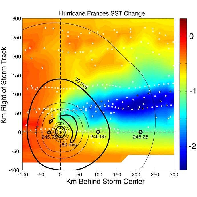
Molinari, J., J.A. Zhang, R.F. Rogers, and D. Vollaro, 2019: Repeated Eyewall Replacement Cycles in Hurricane Frances (2004). Mon. Wea. Rev., 0, https://doi.org/10.1175/MWR-D-18-0345.1.
Nguyen, L.T., R.F. Rogers, J. Zawislak, and J.A. Zhang, 2019: Assessing the Influence of Convective Downdrafts and Surface Enthalpy Fluxes on Tropical Cyclone Intensity Change in Moderate Vertical Wind Shear. Mon. Wea. Rev., 0, https://doi.org/10.1175/MWR-D-18-0461.1.
Wadler, J., R.F. Rogers, and P.D. Reasor, 2018a: The relationship between spatial variations in the structure of convective bursts and tropical cyclone intensification as determined by airborne Doppler radar. Mon. Wea. Rev., 146, 761–780. https://doi.org/10.1175/MWR-D-17-0213.1.
Zhang, J.A. and R.F. Rogers, 2019: Effects of parameterized boundary layer structure on hurricane rapid intensification in shear. Mon. Wea. Rev., 147, 853-871, https://doi.org/10.1175/MWR-D-18-0010.1.
2018
Bowers, G. S., Smith, D. M., Kelley, N. A., Martinez‐McKinney, G. F., Cummer, S. A., Dwyer, J. R., et al. ( 2018). A terrestrial gamma‐ray flash inside the eyewall of Hurricane Patricia. Journal of Geophysical Research: Atmospheres, 123, 4977– 4987. https://doi.org/10.1029/2017JD027771Didlake, A.C., Paul D. Reasor, and R.F. Rogers, W.-C. Lee, 2018: Dynamics of the transition from spiral rainbands to a secondary eyewall in Hurricane Earl (2010). J. Atmos. Sci., 75, 2909–2929, https://doi.org/10.1175/JAS-D-17-0348.1.
Dougherty, E.M., J. Molinari, R.F. Rogers, J.A. Zhang, and J.P. Kossin, 2018: Hurricane Bonnie (1998): Maintaining Intensity during High Vertical Wind Shear and an Eyewall Replacement Cycle. Mon. Wea. Rev., 146, 3383–3399, https://doi.org/10.1175/MWR-D-18-0030.1
Guimond, S. R. J. A. Zhang, J. Sapp, and S. J. Frasier, 2018: Coherent turbulence in the boundary layer of Hurricane Rita (2005) during an eyewall replacement cycle. J. Atmos. Sci., 75, 3071–3093.
Leighton, H., S. Gopalakrishnan, J.A. Zhang, R.F. Rogers, Z. Zhang, and V. Tallapragada, 2018: Azimuthal Distribution of Deep Convection, Environmental Factors, and Tropical Cyclone Rapid Intensification: A Perspective from HWRF Ensemble Forecasts of Hurricane Edouard (2014). J. Atmos. Sci., 75, 275–295, https://doi.org/10.1175/JAS-D-17-0171.1
Wadler, J.B., J.A. Zhang, B. Jaimes, and L.K. Shay, 2018b: Downdrafts and the Evolution of Boundary Layer Thermodynamics in Hurricane Earl (2010) before and during Rapid Intensification. Mon. Wea. Rev., 146, 3545–3565.
2017
Didlake, A.C., G.M. Heymsfield, P.D. Reasor, and S.R. Guimond, 2017: Concentric Eyewall Asymmetries in Hurricane Gonzalo (2014) Observed by Airborne Radar. Mon. Wea. Rev., 145, 729–749, https://doi.org/10.1175/MWR-D-16-0175.1Hazelton, A.T., R.F. Rogers, and R.E. Hart, 2017: Analyzing simulated convective bursts in two Atlantic hurricanes. Part I: Convective burst formation and development. Mon. Wea. Rev., 145(8), 3073-3094, doi: 10.1175/MWR-D-16-0267.1.
Hazelton, A.T., R.E. Hart, and R.F. Rogers, 2017: Analyzing simulated convective bursts in two Atlantic hurricanes. Part II: Intensity change due to convective bursts. Mon. Wea. Rev., 145(8), 3095-3117, doi: 10.1175/MWR-D-16-0268.1.
Kalina, E.A., S. Matrosov, J. Cione, F. Marks, J. Vivekanandan, R. Black, J. Hubbert, M. Bell, D. Kingsmill, and A. White 2017: The Ice Water Paths of Small and Large Ice Species in Hurricanes Arthur (2014) and Irene (2011). J. Appl. Meteorol. DOI: http://dx.doi.org/10.1175/JAMC-D-16-0300.1
Martinez, J., M.M. Bell, J.L. Vigh, and R.F. Rogers, 2017: Examining Tropical Cyclone Structure and Intensification with the FLIGHT+ Dataset from 1999 to 2012. Mon. Wea. Rev., 145, 4401–4421, https://doi.org/10.1175/MWR-D-17-0011.1.
Nguyen, L.T., R.F. Rogers, and P.D. Reasor, 2017: Thermodynamic and Kinematic Influences on Precipitation Symmetry in Sheared Tropical Cyclones: Bertha and Cristobal (2014). Mon. Wea. Rev., 145, 4423–4446, https://doi.org/10.1175/MWR-D-17-0073.1.
Smith, R. K., J. A. Zhang and M. T. Montgomery, 2017: The dynamics of intensification in a Hurricane Weather and Research Forecasting simulation of Hurricane Earl (2010). Q. J. R. Meteorol. Soc., 143, 297-308.
Zhang, J.A., R.F. Rogers, and V. Tallapragada, 2017: Impact of Parameterized Boundary Layer Structure on Tropical Cyclone Rapid Intensification Forecasts in HWRF. Mon. Wea. Rev., 145, 1413–1426, doi: 10.1175/MWR-D-16-0129.1.
2016
Abarca, S.F., M.T. Montgomery, S.A. Braun, and J.P. Dunion, 2016: On the secondary eyewall formation of Hurricane Edouard (2016), Mon. Wea. Rev. 144, 3321-3331, https://doi.org/10.1175/MWR-D-15-0421.1.Guimond, S.R., G.M. Heymsfield, P.D. Reasor, and A.C. Didlake, 2016: The Rapid Intensification of Hurricane Karl (2010): New Remote Sensing Observations of Convective Bursts from the Global Hawk Platform. J. Atmos. Sci., 73, 3617–3639, https://doi.org/10.1175/JAS-D-16-0026.1
Rogers, R.F., J.A. Zhang, J. Zawislak, H. Jiang, G.R. Alvey III, E.J. Zipser, and S.N. Stevenson, 2016: Observations of the structure and evolution of Hurricane Edouard (2014) during intensity change. Part II: Kinematic structure and the distribution of deep convection. Mon. Wea. Rev., 144, 3355-3376.
Zawislak, J., H. Jiang, G.R. Alvey III, E.J. Zipser, R.F. Rogers, J.A. Zhang, and S.N. Stevenson, 2016: Observations of the structure and evolution of Hurricane Edouard (2014) during intensity change. Part I: Relationship between the thermodynamic structure and precipitation. Mon. Wea. Rev., 144, 3333-3354.
2015
Cione, J.J. 2015: The relative roles of the ocean and atmosphere as revealed by buoy air-sea observations in hurricanes. Mon. Wea. Rev. doi: 10.1175/MWR-D-13-00380.1Hazelton, A., R.F. Rogers, and R.Hart, 2015: Shear-Relative Asymmetries in Tropical Cyclone Eyewall Slope. Mon. Wea. Rev., 143, 883-903.
Reasor, P.D. and M.T. Montgomery, 2015: Evaluation of a Heuristic Model for Tropical Cyclone Resilience. J. Atmos. Sci., 72, 1765–1782, https://doi.org/10.1175/JAS-D-14-0318.1
Rogers, R.F., P.D. Reasor, and J.A. Zhang, 2015: Multiscale structure and evolution of Hurricane Earl (2010) during rapid intensification. Mon. Wea. Rev., 143, 536-562.
Susca-Lopata, G., J. Zawislak, E.J. Zipser, and R.F. Rogers, 2015: The role of observed environmental conditions and precipitation evolution in the rapid intensification of Hurricane Earl (2010). Mon. Wea. Rev., 143, 2207-2223.
Zhang, J. A., and F. D. Marks, 2015: Effects of horizontal diffusion on tropical cyclone intensity change and structure in idealized three-dimensional numerical simulations, Mon. Wea. Rev., 143, 10: 3981-3995.
Zhang, J. A., D. S. Nolan, R. F. Rogers, and V. Tallapragada, 2015: Evaluating the impact of improvements in the boundary layer parameterization on hurricane intensity and structure forecasts in HWRF, Mon. Wea. Rev., 143, 3136-3155
2014
Dunion, J.P., C.D. Thorncroft, and C.S. Velden, 2014: The tropical cyclone diurnal cycle of mature hurricanes. Mon. Wea. Rev., 142, 3900-3919, https://doi.org/10.1175/MWR-D-13-00191.1.
Looking for Literature? Search our Publication Database.