 Back to Tropical Cyclone
Observation Page | Back
to Main FAQ Page
Subject: H5) What's it like to go through a hurricane
on the ground ? What are the early warning signs of an approaching
tropical cyclone ?
Back to Tropical Cyclone
Observation Page | Back
to Main FAQ Page
Subject: H5) What's it like to go through a hurricane
on the ground ? What are the early warning signs of an approaching
tropical cyclone ?
Contributed by Neal Dorst (HRD)
Just as every person is an individual, every hurricane is different.
So every experience with such a storm will be unique. The summary
below is of a general sequence of events one might expect from a
Category 2 hurricane approaching a coastal area. What you might
experience could be vastly different.
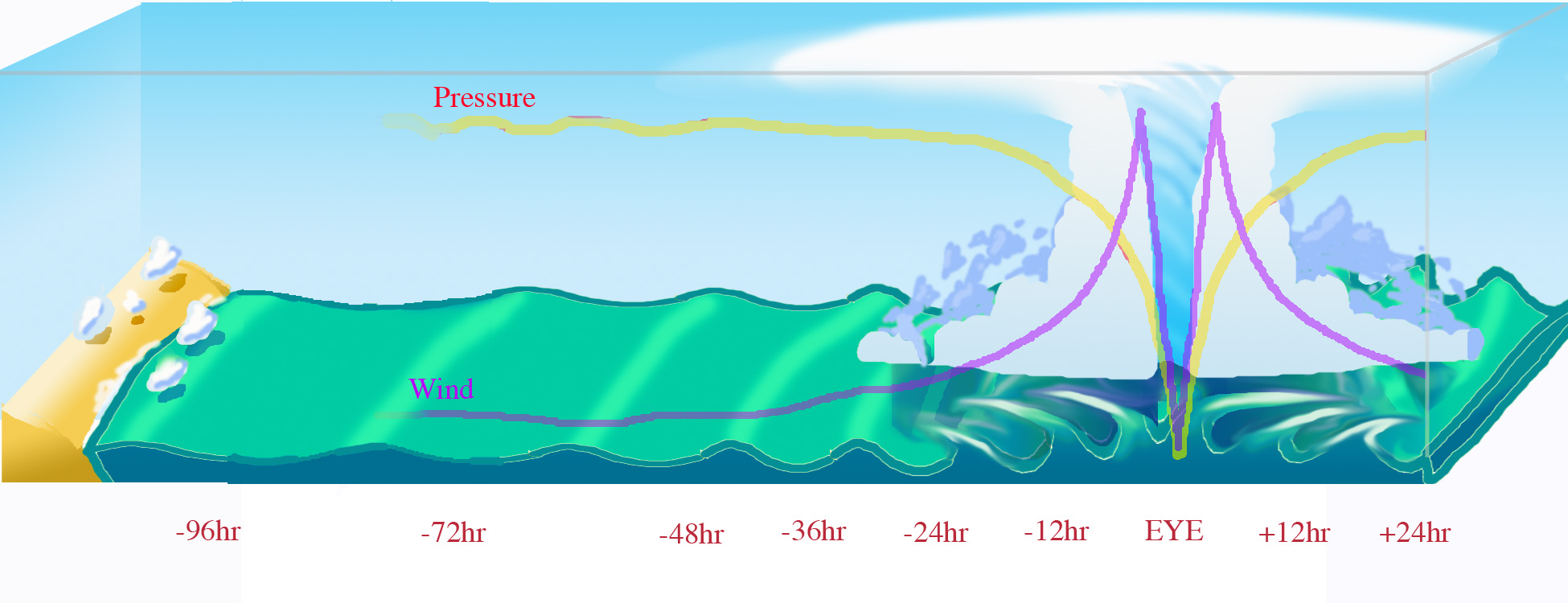
- 96 hours before landfall
At first there aren't any apparent signs of a storm. The barometer is steady, winds are light and variable, and fair weather cumulus clouds dot the sky. But the perceptive observer will note a swell on the ocean surface of about a meter (3 feet) in height with a wave coming ashore every ten seconds. These waves race out far ahead of a storm at sea, but could easily be masked by locally wind driven waves.
- 72 hours before landfall
Little has changed, except that the swell has increase to about
2 meters (6 feet) in height and the waves now come in every nine seconds. This means that the storm, still far over the horizon, is approaching.
- 48 hours before landfall
If anything, conditions have improved. The sky is now clear of clouds, the barometer is steady, and the wind is almost calm. The swell is now about 3 m (9 feet) and coming in every 8 seconds. A hurricane watch is issued, and areas with long evacuation times are given the order to begin.
- 36 hours before landfall
The first signs of the storm appear. The barometer is falling slightly, the wind is around 5 m/s (10 kts, 11 mph), and the ocean swell is about 4m (13 feet) in height and coming in 7 seconds apart. On the horizon a large mass of white cirrus clouds appear. As the veil of clouds approaches it covers more of the horizon. A hurricane warning is issued and low lying areas and people living in mobile homes are ordered to evacuate.
- 30 hours before landfall
The sky is now covered by a high overcast. The barometer is falling at .1 millibar per hour (.003 inches of Hg/hr), and the winds pick up to about 10 m/s (20 kts, 23 mph). The ocean swell, coming in only 5 seconds apart, is beginning to be obscured by wind driven waves, and small whitecaps begin to appear on the ocean surface.
- 24 hours before landfall
In addition to the overcast, small low clouds streak by overhead. The barometer is falling by .2 mb/hr (.006"Hg/hr), the wind picks up to 15 m/s (30 kts, 34 mph). The wind driven waves are covered in whitecaps and streaks of foam begin to ride over the surface. Evacuations should be completed and final preparations made by this time.
- 18 hours before landfall
The low clouds are thicker and bring driving rain squalls with
gusty winds. The barometer is steadily falling at half a millibar per
hour (.015 "Hg/hr), and the winds are whistling by at 20 m/s (40 kts, 46 mph). It is hard to stand against the wind.
- 12 hours before landfall
The rain squalls are more frequent and the winds don't diminish after they depart. The cloud ceiling is getting lower, and the barometer is falling at 1 mb/hr (.029 "Hg/hr). The wind is howling at hurricane force at 32 m/s (64 kts, 74 mph), and small, loose objects are flying through the air and branches are stripped from trees. The sea advances with every storm wave that crashes ashore and the surface is covered with white streaks and foam patches.
- 6 hours before landfall
The rain is constant now and the 40 m/s wind (80 kts, 92 mph) drives it horizontally. The barometer is falling 1.5 mb/hr (.044 "Hg/hr), and the storm surge has advanced above the high tide mark. It is impossible to stand upright outside without bracing yourself, and heavy objects like coconuts and plywood sheets become airborne missiles. The wave tops are cut off and make the sea surface a whitish mass of spray.
- 1 hour before landfall
It didn't seem possible, but the rain has become heavier, a torrential downpour. Low areas inland become flooded from the rain. The winds are roaring at 45 m/s (90 kts, 104 mph), and the barometer is free-falling at 2 mb/hr (.058 "Hg/hr). The sea is white with foam and streaks. The storm surge has covered coastal roads and 5 meter (16 foot) waves crash into buildings near the shore.
- The eye
Just as the storm reaches its peak, the winds begin to slacken, and the sky starts to brighten. The rain ends abruptly and the clouds break and blue sky is seen. However the barometer continues falling at 3 mb/hr (.09 "Hg/hr) and the storm surge reaches the furthest inland. Wild waves crash into anything in the grasp of the surge. Soon the winds fall to near calm, but the air is uncomfortably warm and humid. Looking up you can see huge walls of cloud on every side, brilliant white in the sunlight.
At this point, the barometer stops falling and in a moment begins to rise, soon as fast as it fell. The winds begin to pick up slightly and the clouds on the far side of the eyewall loom overhead.
- 1 hour after landfall
The sky darkens and the winds and rain return just a heavy as they were before the eye. The storm surge begins a slow retreat, but the monstrous waves continue to crash ashore. The barometer is now rising at 2 mb/hr (.058 "Hg/hr). The winds top out at 45 m/s (90 kts, 104 mph), and heavy items torn loose by the front side of the storm are thrown about and into sides of buildings that had been in the lee before the eye passed.
- 6 hours after landfall
The flooding rains continue, but the winds have diminished to a 'mere' 40 m/s (80 kts, 92 mph). The storm surge is retreating and pulling debris out to sea or stranding sea borne objects well inland. It is still impossible to go outside.
- 12 hours after landfall
The rain now comes in squalls and the winds begin to diminish after each squall passes. The cloud ceiling is rising, as is the barometer at 1 mb/hr (.029 "Hg/hr). The wind is still howling at near hurricane force at 30 m/s (60 kts, 69 mph), and the ocean is covered with streaks and foam patches. The sea level returns to the high tide mark.
- 24 hours after landfall
The low clouds break into smaller fragments and the high overcast is seen again. The barometer is rising by .2 mb/hr (.006"Hg/hr), the wind falls to 15 m/s (30 kts, 34 mph). The surge has fully retreated from land, but the ocean surface is still covered by small whitecaps and large waves.
- 36 hours after landfall
The overcast has broken and the large mass of white cirrus clouds disappears over the horizon. The sky is clear and the sun seems brilliant. The barometer is rising slightly, the wind are a steady 5 m/s (10 kts, 11 mph). All around are torn trees and battered buildings. The air stinks of dead vegetation and muck that was dredged by the storm from the bottom of the sea to cover the shore. The all clear is given.
Last updated August 13, 2004
Back to Tropical Cyclone
Observation Page | Back
to Main FAQ Page
|
|
