The Beginning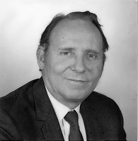 Since 1944 the United States Navy (USN) and the United
States Air Force (USAF) had been flying reconnaissance missions
into tropical cyclones, to help warn civilians as well as military
personnel of approaching typhoons and hurricanes. Robert H.
Simpson, during the late 1940s and early 1950s, had used these operational
reconnaissance missions to take scientific measurements of hurricanes.
But it wasn't until 1954, when Hurricanes Carol, Edna, and Hazel
swept up the eastern coast of the United States (Hazel went directly
over Washington, D.C.), that policymakers took the hurricane threat
seriously enough to finance such research. Congress in 1955 authorized
additional funding for the United States Weather Bureau (USWB) to
create the National Hurricane Research Project (NHRP) which
was to conduct research into hurricanes in hopes of improving scientific
understanding of them, which in turn would improve forecasting. Since 1944 the United States Navy (USN) and the United
States Air Force (USAF) had been flying reconnaissance missions
into tropical cyclones, to help warn civilians as well as military
personnel of approaching typhoons and hurricanes. Robert H.
Simpson, during the late 1940s and early 1950s, had used these operational
reconnaissance missions to take scientific measurements of hurricanes.
But it wasn't until 1954, when Hurricanes Carol, Edna, and Hazel
swept up the eastern coast of the United States (Hazel went directly
over Washington, D.C.), that policymakers took the hurricane threat
seriously enough to finance such research. Congress in 1955 authorized
additional funding for the United States Weather Bureau (USWB) to
create the National Hurricane Research Project (NHRP) which
was to conduct research into hurricanes in hopes of improving scientific
understanding of them, which in turn would improve forecasting.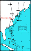 Simpson was appointed Director of the twenty-two person Project
and in one year he had the operational headquarters set up at the
West Palm Beach, Florida airport. USAF loaned three aircraft and
their crews to the effort, and on August 13, 1956 the first NHRP
flight was made into Hurricane Betsy off the Turks and Caicos Islands.
Simpson was appointed Director of the twenty-two person Project
and in one year he had the operational headquarters set up at the
West Palm Beach, Florida airport. USAF loaned three aircraft and
their crews to the effort, and on August 13, 1956 the first NHRP
flight was made into Hurricane Betsy off the Turks and Caicos Islands. The USAF aircraft used in the first three years of the Project
were a B47 jet and two B50 ex-bombers, which were instrumented to
take temperature, humidity, and pressure measurements and punch
them on computer cards, and an on-board radar scope, which was photographed
at regular intervals. Researchers were initially interested in describing
the three dimensional structure of hurricanes and in observing the
middle and upper level winds which were thought to steer the storm.
Over the next several years an experiment was carried out in which
a balloon-borne radio beacon was released in a hurricane's eye and
the wind center was tracked remotely.
The USAF aircraft used in the first three years of the Project
were a B47 jet and two B50 ex-bombers, which were instrumented to
take temperature, humidity, and pressure measurements and punch
them on computer cards, and an on-board radar scope, which was photographed
at regular intervals. Researchers were initially interested in describing
the three dimensional structure of hurricanes and in observing the
middle and upper level winds which were thought to steer the storm.
Over the next several years an experiment was carried out in which
a balloon-borne radio beacon was released in a hurricane's eye and
the wind center was tracked remotely. 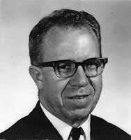 The Project was also involved in setting up upper-air stations
around the Caribbean, and in installing WSR-57 radars in American
coastal locations. There was a program of photographing hurricanes
from low flying rockets that was soon made obsolete by the introduction
of weather satellites. 1958 was the most productive year of this
era, with twenty-three missions being flown, and important papers
being published on mean atmospheric soundings, hurricane rainfall
distributions, storm surge surveys, and radar descriptions of hurricane
structure. At the end of that hurricane season the USAF
offered to transfer their aircraft to the Project outright.
But a Commerce study found it would be more economical to lease their
own aircraft and hire and train their own personnel. Simpson
left the Directorship to obtain a doctorate, and then become Director of
Project STORMFURY, and Cecil Gentry became the new NHRP Director.
The Project was also involved in setting up upper-air stations
around the Caribbean, and in installing WSR-57 radars in American
coastal locations. There was a program of photographing hurricanes
from low flying rockets that was soon made obsolete by the introduction
of weather satellites. 1958 was the most productive year of this
era, with twenty-three missions being flown, and important papers
being published on mean atmospheric soundings, hurricane rainfall
distributions, storm surge surveys, and radar descriptions of hurricane
structure. At the end of that hurricane season the USAF
offered to transfer their aircraft to the Project outright.
But a Commerce study found it would be more economical to lease their
own aircraft and hire and train their own personnel. Simpson
left the Directorship to obtain a doctorate, and then become Director of
Project STORMFURY, and Cecil Gentry became the new NHRP Director.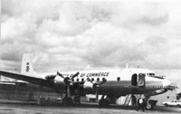 There was a hiatus in field research activity until 1960 when NHRP's
two leased DC6 airplanes were instrumented and available. Later that
season a B-57 jet, on loan from the Air Force was made operational.
In 1961 NHRP's Flight Operations Group (the aircraft, crews and
their ground support) were split from NHRP into a separate
organization, the Research Flight Facility (RFF). This organization
would eventually become NOAA's
Aircraft Operations Center (AOC). The Project's researchers were
left to focus on collecting and interpreting the data, while RFF's
personnel concentrated on aircraft maintenance and operations.
There was a hiatus in field research activity until 1960 when NHRP's
two leased DC6 airplanes were instrumented and available. Later that
season a B-57 jet, on loan from the Air Force was made operational.
In 1961 NHRP's Flight Operations Group (the aircraft, crews and
their ground support) were split from NHRP into a separate
organization, the Research Flight Facility (RFF). This organization
would eventually become NOAA's
Aircraft Operations Center (AOC). The Project's researchers were
left to focus on collecting and interpreting the data, while RFF's
personnel concentrated on aircraft maintenance and operations. Continue... |
About HRD
Links of Interest
AOML Tools & Resources
Employee Tools
Stay Connected
|

| ||