|
Tropical cyclone wind radii estimation utilizing an empirical inland wind decay modelPrinciple Investigator:
John Kaplan (NOAA/AOML/HRD) Methodology A technique for estimating the wind radii and maximum wind of landfalling tropical cyclones in the Atlantic and eastern North Pacific basins utilizing an empirical decay model (Kaplan and DeMaria 1995, 2001) has been developed as part of the NOAA Joint Hurricane Testbed (JHT) (Kaplan et al. 2007). The aforementioned technique employs a revised version of the decay model (DeMaria et al. 2006) to generate estimates of the maximum wind and 34,50 and 64 kt wind radii of landfalling storms where the input required to run the model is obtained from the latest official NHC interpolated forecast. This particular application of the decay model was accepted for operational use prior to the 2008 Hurricane season and is currently running on a server at NHC where the output is available for use by forecasters for landfalling Atlantic and eastern North Pacific basin storms. A more completed description of this particular application of the decay model can be found in Kaplan et al. (2007).
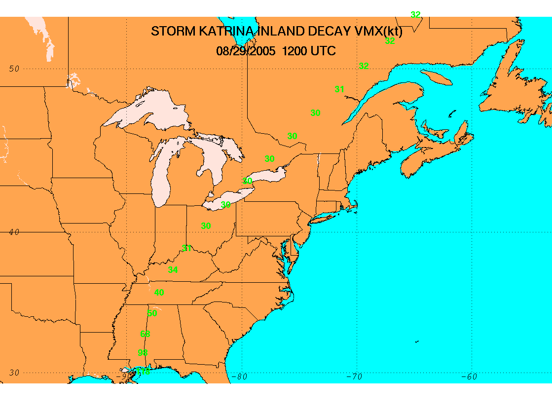 Fig. 1 Decay model estimated maximum sustained wind estimated (green) obtained based upon input from the 1200 UTC 29 August NHC official interpolated forecast cycle for Hurricane Katrina (2005). Figure 1 shows an example of the decay model forecasted maximum wind that was obtained for Hurricane Katrina (2005) using the operational NHC forecasted input information that was available at 1200 UTC 29 August. Although this forecast was not issued in real-time it is an independent example of the model's performance since the revised version of the decay model described above was derived using only landfalling cases from 1967-1993. As can been in Fig. 2, both the OFCI and decay model forecasted intensities were too high although the decay model values were in somewhat better agreement for this particular forecast. Since the overland intensity forecast is very sensitive to a storm's landfall intensity, the finding that the inland intensities were too high might be due, in part, to the fact that the initial intensity used to generate both the OCFI and decay models forecasts was about 10 kt higher that that which was observed.
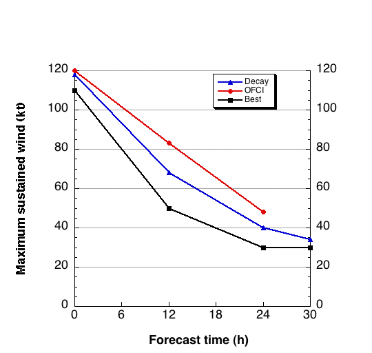 Fig. 2 Decay model (Decay) and official interpolated (OFCI) maximum sustained wind estimates for the 1200 UTC 29 August forecast cycle for Hurricane Katrina. The NHC best track estimates (Best) for this time period are also depicted. Figure 3 shows the decay model forecast errors as a function of radius from the storm center where the decay model errors were computed for all available wind observations that were collected as part of the HRD Hurricane Field Program (HFP) landfall experiment. It is important to note that prior to computing the model errors all of the wind observations were first standardized to a 1-minute 10-m wind assuming open terrain exposure using the methods of Powell et al. (1996). Also, only observations that occurred during the time period when Katrina was still tropical were verified. Inspection of the figure indicates that the decay model forecasted wind speeds had a high bias of 2 to 7 kt and that the mean error was about 14 kt. The finding of a high bias at the individual observation locations appears to be consistent with the results in Fig. 2 that indicated that the decay model forecasted maximum winds were also higher than those that were observed. In the future, similar comparisons between the model forecasted and observed winds will also be made for 3-D numerical models like HWRF and GFDL to ascertain how well those particular models predict inland decay. 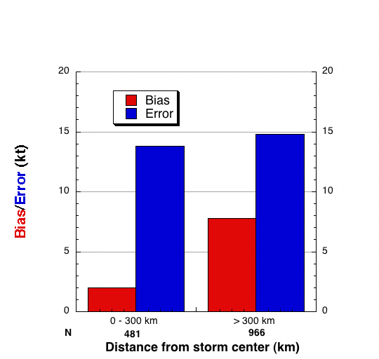 Fig. 3 Decay model wind error (blue) and biases (red) as a function of radial distance from the storm center. The number of observations in each of the two radial bins (N) is also depicted along the x-axis. The mean time after landfall of all of the observations that were verified was about 6 h. FY10-11 Achievements
FY12-13 Milestones
DeMaria, M., J. A. Knaff, and J. Kaplan, 2006: On the decay of tropical cyclone winds crossing narrow landmasses., J. Appl. Meteor. and Clim., 45, 491-499. Kaplan, J. , and M. DeMaria, 1995: A simple empirical model for predicting the decay of tropical cyclone winds after landfall. J. Appl. Meteor., 34, 2499-2512. Kaplan, J., and M. DeMaria, 2001: On the decay of tropical cyclone winds after landfall in the New England region. J. Appl. Meteor., 40, 280-286. Powell, D., P.P. Dodge, and M.L. Black, 1996: Hurricane Andrew's landfall in south Florida. Part I: Standardizing measurements for documentation of surface wind fields. Wea. Forecasting, 11, 304-328.
Last modified: 7/14/2011 |
Links of Interest
AOML Tools & Resources
Employee Tools
Stay Connected
|

| ||