|
| 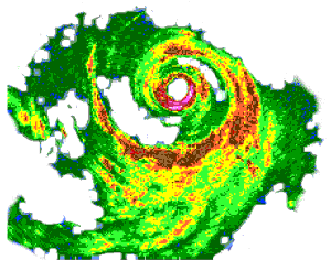 Radar reflectivity patterns in hurricanes provide
a good means for flow visualization even though they represent
precipitation, mostly rain, not winds. Descending motion
occupies precipitation--free areas, such as the eye. The axis
of the cyclone's rotation, here denoted by the hurricane
symbol, lies near the center of the eye. The eyewall surrounds
the eye. In intense hurricanes, it may contain reflectivities
as high as 50 dB(Z), magenta in this picture, equivalent to
rainfall rates of 74 mm/h (2.9 in/hr). Less extreme
reflectivities--40 dB(Z), red here--characterize most
convective rainfall in the eyewall and spiral bands where
rainfall rates are 13 mm/h (0.5 in/h). The vertical velocities
(both up and downdrafts, although the downdrafts are a little
weaker) in convection with highest reflectivity may reach 25
m/s (5000 ft/min), but typical vertical velocities are less
than 5 m/s (1000 ft/min). Such intense convection occupies only
a small fraction of the hurricane's area. Outside convection,
reflectivities are still weaker--30 dB(Z), yellow
here--equivalent to 2.4 mm/h (a little less than 0.1 in/h) rain
rate. This "stratiform rain" falls out of the anvil cloud that
grows from the convection. The spiral bands tend to lie along
the friction-layer wind that spirals inward toward the eyewall.
The more-circular swirling wind above the friction layer
(magenta arrow) blows through the spirals, spreading convective
debris downwind.
Radar reflectivity patterns in hurricanes provide
a good means for flow visualization even though they represent
precipitation, mostly rain, not winds. Descending motion
occupies precipitation--free areas, such as the eye. The axis
of the cyclone's rotation, here denoted by the hurricane
symbol, lies near the center of the eye. The eyewall surrounds
the eye. In intense hurricanes, it may contain reflectivities
as high as 50 dB(Z), magenta in this picture, equivalent to
rainfall rates of 74 mm/h (2.9 in/hr). Less extreme
reflectivities--40 dB(Z), red here--characterize most
convective rainfall in the eyewall and spiral bands where
rainfall rates are 13 mm/h (0.5 in/h). The vertical velocities
(both up and downdrafts, although the downdrafts are a little
weaker) in convection with highest reflectivity may reach 25
m/s (5000 ft/min), but typical vertical velocities are less
than 5 m/s (1000 ft/min). Such intense convection occupies only
a small fraction of the hurricane's area. Outside convection,
reflectivities are still weaker--30 dB(Z), yellow
here--equivalent to 2.4 mm/h (a little less than 0.1 in/h) rain
rate. This "stratiform rain" falls out of the anvil cloud that
grows from the convection. The spiral bands tend to lie along
the friction-layer wind that spirals inward toward the eyewall.
The more-circular swirling wind above the friction layer
(magenta arrow) blows through the spirals, spreading convective
debris downwind. |
|
Links of Interest
AOML Tools & Resources
Employee Tools
Stay Connected
|
