
NOAA’s G-IV and two P-3 Hurricane Hunter aircraft took off from Lakeland, FL, at 1:30 PM, 10:30 AM, and 4:30 PM EDT, respectively, on September 14th for continued missions investigating Hurricane Sally’s circulation.
Tasked by the Environmental Modeling Center (EMC), NOAA’s P-3 aircraft each performed 4 passes through the system’s center, observing the atmospheric conditions in all quadrants of Sally from an altitude of 10,000 feet.
La División de Investigación de Huracanes del AOML encargó a la aeronave G-IV de la NOAA que estudiara la interacción de Sally con el entorno en el que se encuentra el sistema. El G-IV de la NOAA realizará dos circunnavegaciones concéntricas a 45.000 pies alrededor de la periferia sur de la tormenta.
AOML scientists providing onboard and remote support for these missions ensure that Tail Doppler Radar, dropsonde, and Stepped Frequency Microwave Radiometer (SFMR) measurements allow for adequate coverage of the storm environment. These data are quality controlled and ingested into operational weather models to improve performance and reduce uncertainty in Sally’s forecast.
High-altitude G-IV dropsonde measurements, in coordination with those from onboard P-3 sensors, Tail Doppler Radar, SFMR, and inner-core dropsonde data, allow hurricane scientists to address science objectives to identify processes important for intensification when a tropical cyclone experiences moderate vertical wind shear. Vertical wind shear, defined as a change in winds with height, can inhibit the ability for a tropical cyclone to intensify.

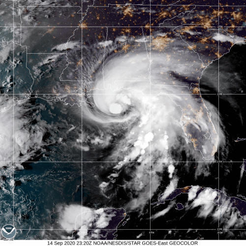
Tail Doppler Radar analyses indicate that Sally’s circulation appears tilted with height, which is supported by the asymmetric representation of its associated precipitation. Overnight, NOAA’s Hurricane Hunter operations captured the effects of vertical wind shear on Sally’s vortex prior to its strengthening in the Gulf of America.
Reconnaissance into Hurricane Sally provided the opportunity to conduct instrument validation tasks while accomplishing EMC directives. Wave and wind observations from onboard SFMR and Wide Swath Radar Altimeter (WSRA) will be compared to coincident dropsondes and available ocean buoy and profiler data (Argo) to determine and improve their accuracy.

La científica principal del proyecto en tierra, Heather Holbach, PhD, enfatizó que las mediciones de la altura de las olas en la superficie de la WSRA indicaron alturas de olas de más de 18 pies en el lado norte del huracán.
"El sistema sigue organizándose mejor, pero todavía hay algunos indicios de que la cizalla del viento del este estaba impactando en el huracán", dijo Holbach.
Despite considerable wind shear, Hurricane Sally has rapidly intensified, likely due to warm ocean waters and an otherwise favorable environment. The National Hurricane Center (NHC) issued hurricane warnings extending from Louisiana to the Florida panhandle and predicts that the slow moving system will produce hazardous conditions across the Southeast regardless of the exact landfall location.

Five tropical cyclones currently exist in the Atlantic basin, tying the record for the largest number of tropical cyclones at one time. Hurricane experts have coordinated their assets to investigate the environment of multiple storms in addition to Hurricane Sally, an immediate threat to the United States.
Los cazadores de huracanes de la NOAA investigaron el huracán Paulette para una misión de la NHC, recogiendo mediciones que permitieron a los expertos en huracanes determinar la posición e intensidad de la circulación. Las Bermudas recibieron un golpe directo del sistema, que tocó tierra como un huracán de categoría 2. Se espera que el huracán Paulette se fortalezca hasta alcanzar una intensidad de huracán mayor antes de disiparse sobre las aguas más frías del Atlántico.

Los dos aviones P-3 continuarán las misiones a Sally desde Lakeland, FL, mientras que el G-IV se dirige a St. Croix para misiones científicas en la tormenta tropical Teddy.
>> Scientist K. Ryan
>> Edited by: R. Kravetz
For the latest information about tropical cyclones and other weather systems, please visit the NOAA/NWS/National Hurricane Center.
For information on numerical prediction of tropical cyclones, please visit NOAA/NCEP/Environmental Modeling Center.
To access updates on the Intensity Forecasting EXperiment (IFEX) and other activities via Facebook, Twitter, or RSS feed, check out the NOAA/AOML/HRD page.
To directly access updates on IFEX HFP Operations via our WordPress blog on the web, check the site: https://noaahrd.wordpress.com/category/ifex-hurricane-field-program/
DISCLAIMER: The above discussion is intended to provide a brief summary of recent and future HRD Hurricane Field Program Operations. Any use of this material beyond its original intent is prohibited without permission of the HRD Director, Frank Marks (Frank.Marks@noaa.gov). Media inquiries should be directed to AOML Communications (aoml.communications@noaa.gov), Monica Allen (301-734-1123) or Monica.Allen@noaa.gov.