AOML's Hurricane Observation & Emerging Technologies Program
Observing Hurricanes Using Airborne and Experimental Technologies
Quiénes somos
Objetivos
Our objective is to obtain observations in and around tropical cyclones to improve our understanding of their structure and intensity change, especially in regions that have historically been difficult to observe. We also seek to test emerging technologies to improve the quality of such observations.
Activities
Observations of tropical cyclones are integral to understanding changes to their track, intensity, and structure, and to improving the model systems used to make forecasts of their impacts.
Researchers at AOML develop and deploy an array of instruments and emerging technologies to measure conditions in and around tropical cyclones, work on quality control and transmission of the data to operational centers for data assimilation into models, validate new and remote observational platforms including satellites, and develop and verify optimal sampling strategies for forecast improvement.
The data from these instruments are vital to enhance forecasters’ understanding of tropical cyclone dynamics and physics behavior and their representation in numerical models and to improve hurricane prediction models, leading to better preparedness and response strategies.
The annual Hurricane Field Program has a variety of experiments to research the tropical cyclone lifecycle, from genesis to decay, as well as ocean observations and satellite validation, all in support of NOAA’s Advancing the Prediction of Hurricanes Experiment (APHEX). APHEX broadens the goals of the 2005-2020 Intensity Forecasting EXperiment by incorporating current, 5-year Hurricane Forecast Improvement Program (HFIP) priorities around better forecasting and communicating for all hazards (wind, rain, surge, and tornadoes).
In partnership with NOAA’s Environmental Modeling Center; National Hurricane Center; Aircraft Operations Center; National Environmental Satellite, Data, and Information Service; and AOML’s Physical Oceanography Division, the goal of APHEX is to improve understanding and prediction of hurricane track, intensity, three-dimensional structure, and hazards by collecting observations that will aid in the improvement of current operational hurricane models, such as the Hurricane Analysis and Forecast System (HAFS) model, and the development of the next-generation operational model and data assimilation systems.
AOML seeks to test new observing systems and concepts of operations to improve the scientific understanding and prediction of tropical cyclones (TCs). NOAA’s Emerging Technologies TC Team investigates, tests, and implements new and promising technologies that sample atmospheric and oceanic environments that are either too dangerous or too difficult for direct human observation.
Airborne Observation Team
Emerging Technology Team
Our Hurricane Field Program
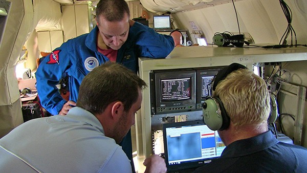
Each year AOML scientists participate in the Hurricane Field Program (HFP) monitoring instruments aboard the NOAA aircraft. These scientists are both onboard the aircraft and participating remotely from the ground. Tasks include quality controlling dropsonde data before it is sent out to the network, processing Tail Doppler Radar to produce wind fields of the hurricane’s inner core, and providing real-time scientific input for the execution of flight patterns, target selection, etc..

Recent Research
Publicaciones
Rojas, B.S., A.C. Didlake Jr., and J.A. Zhang. Asymmetries during eyewall replacement cycles of Hurricane Ivan (2004). Monthly Weather Review, 152(8):1741-1761, https://doi.org/10.1175/MWR-D-23-0129.1 2024 FY2024
Shimada, U., P.D. Reasor, R.F. Rogers, M.S. Fischer, F.D. Marks, J.A. Zawislak, And J.A Zhang. Shear-relative asymmetric kinematic characteristics of intensifying hurricanes as observed by airborne Doppler radar Monthly Weather Review, 152(2):491-512, https://doi.org/10.1175/MWR-D-22-0340.1 2024 FY2024
Rogers, R.F., and J.A. Zhang. Airborne Doppler radar observations of tropical cyclone boundary layer kinematic structure and evolution during landfall. Geophysical Research Letters, 50(23):e2023GL105548, https://doi.org/10.1029/2023GL105548 2023 FY2024
Zhang, C., G.R. Foltz, A.M. Chiodi, C.W. Mordy, C.R. Edwards, C. Meinig, D. Zhang, E. Mazza, E.D. Cokelet, E.F. Burger, F. Bringas, G.J. Goni, H.G. Hristova, H.-S. Kim, J.A. Trinanes, J.A. Zhang, K.E. Bailey, K.M. O’Brien, M. Morales-Caez, N. Lawrence-Slavas, R. Jenkins, S.S. Chen, and X. Chen. Hurricane observations by uncrewed systems. Bulletin of the American Meteorological Society, 104(10):E1893-E1917, https://doi.org/10.1175/BAMS-D-21-0327.1 2023 FY2024
Barron, N.R., A.C. Didlake, and P.D. Reasor. Statistical analysis of convective updrafts in tropical cyclone rainbands observed by airborne Doppler radar. Journal of Geophysical Research-Atmospheres, 127(6):e2021JD035718, https://doi.org/10.1029/2021JD035718 2022 FY2022
Fischer, M.S., P.D. Reasor, R.F. Rogers, and J.F. Gamache. An analysis of tropical cyclone vortex and convective characteristics in relation to storm intensity using a novel airborne Doppler radar database. Monthly Weather Review, 150(9):2255-2278, https://doi.org/10.1175/MWR-D-21-0223.1 2022 FY2022
Nuestros Socios
Over the past several decades, we have collaborated closely with the Environmental Modeling Center, Aircraft Opertions Center, and the National Hurricane Center to develop and improve airborne observations in tropical cyclones during our annual Hurricane Field Program.


