Biogeochemical-Argo Program
Using autonomous floats to observe biogeochemical processes of the ocean
SCROLL TO LEARN MORE
What We Do
AOML’s Biogeochemical-Argo Program utilizes autonomous robotic floats to collect high-resolution data across the Gulf of America and the Caribbean – two historically under-observed regions. By leveraging an integrated sensor network, scientists are performing cutting-edge research to fill critical data gaps and address long-standing questions regarding ocean health and marine phenomena.
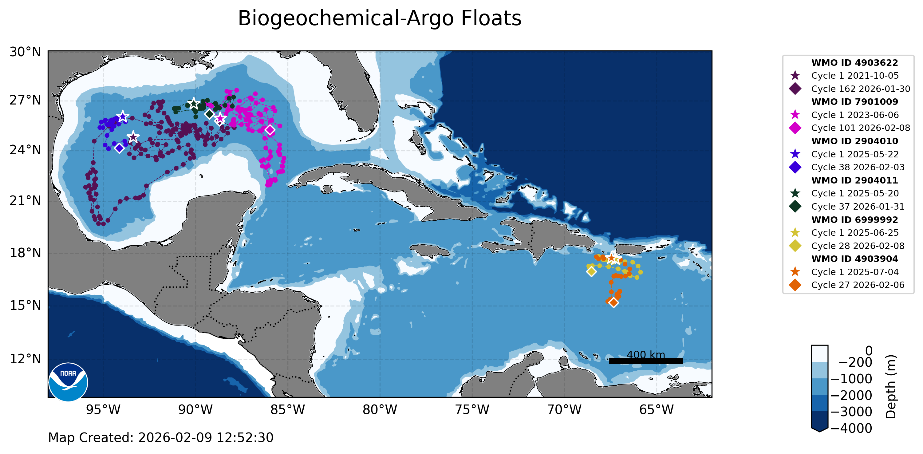
Carribbean

Gulf Region

Top News
In the wake of hurricanes: satellites and robots reveal an altered biogeochemical landscape
February 23, 2026
On August 30, 2023, Hurricane Idalia made landfall as a major Hurricane in Florida’s Big Bend after meandering through the northwestern Caribbean and intensifying over the warm waters of the Gulf of America. In its aftermath, damage on land was immediately visible, but observations from satellites and ocean-going robots revealed that the ocean was also […]


Read More News
")
Research Impacts & Key Findings
Why is this work important?
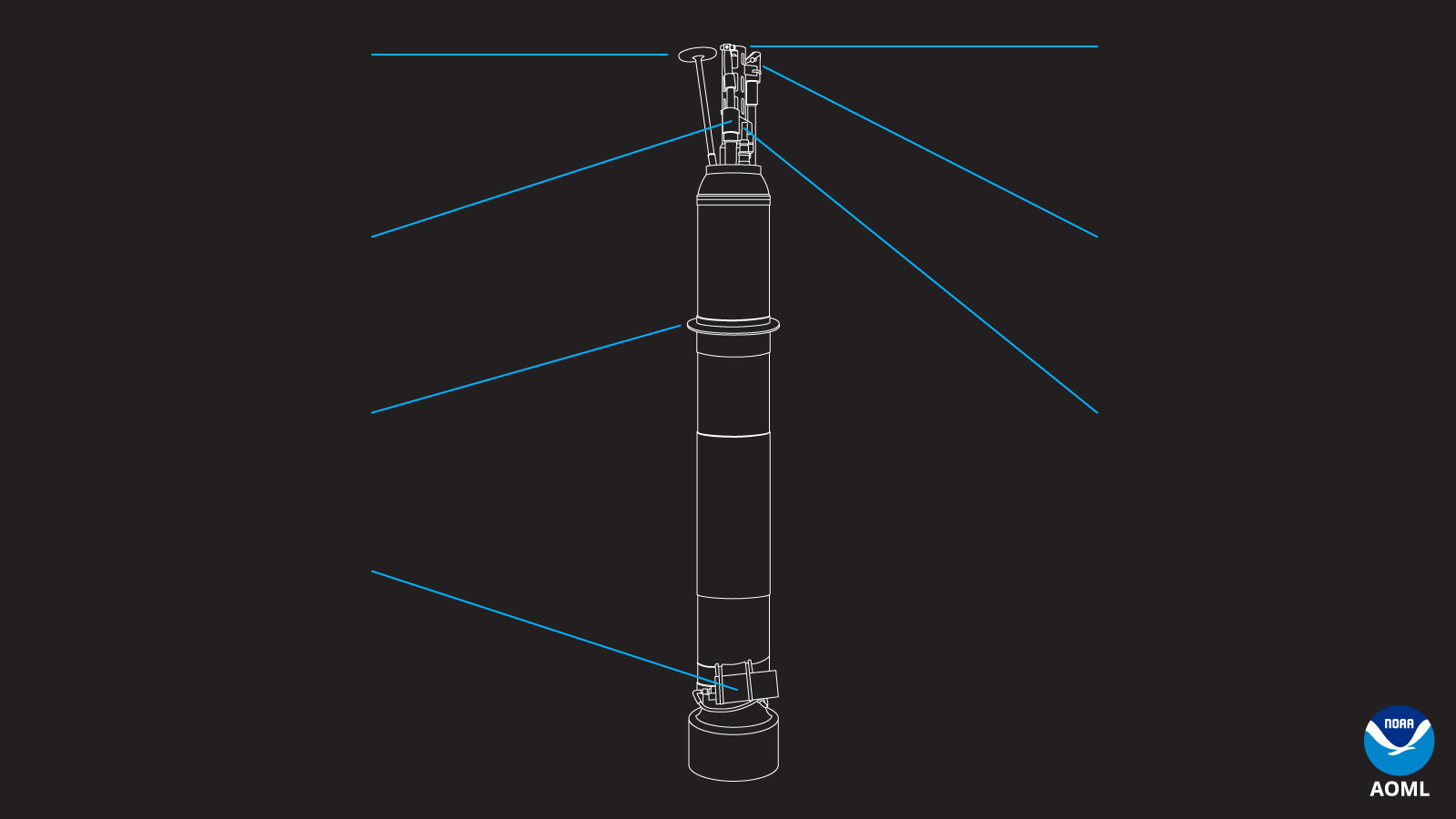
While Core Argo floats—which specifically measure temperature and salinity down to 2,000 meters— revolutionized oceanography by providing a global “heartbeat” of physical data, Biogeochemical (BGC) Argo floats transform that heartbeat into a full medical workup. The primary value of the BGC-Argo lies in its ability to bridge the gap between physical movements and biological health; by adding sensors for oxygen, pH, nitrate, chlorophyll, and ocean particles, these floats allow scientists to observe “ocean breathing” and carbon uptake in real-time. BGC-Argo floats provide the empirical evidence needed to track ocean acidification, deoxygenation, and the efficiency of the biological carbon pump. Core Argo floats tell us how the ocean is moving and warming, the BGC-Argo floats tell us how the ocean is surviving and functioning as a living ecosystem under the pressure of climate change
Why Are We Interested in These Variables?
Click the icons to learn more
Oxygen is required by most living organisms. Oxygen data collection is extremely important in an ecosystem such as the Gulf of America with abundant nutrients and runoff from the Mississippi River. These excess nutrients and pollutants can create areas lacking sufficient oxygen levels (dead zones, or hypoxic zones) which can be deadly for certain species.
Nitrate is a nutrient that is necessary for photosynthesis and primary production in the ocean. Too much nitrate can be harmful to marine life.
The collection of pH data informs the acidity of the ocean. With the surface ocean absorbing nearly one third of human-released CO2, the ocean has become more acidic since the industrial revolution. Ocean acidification impacts carbonate ions that form shells, certain algae, and hard corals.
Chlorophyll is a pigment in primary producers that can be detected to understand concentrations at the base of the food web.
Ocean particulates are also measured through the bio-optical sensor containing Chlorophyll a, particulate organic matter and zooplankton. These measurements can aid in food web dynamics on multiple trophic levels.
BGC Argo Data Access and Visualization
All Argo data are distributed through the Argo Global Data Assembly Centers (Coriolis, USGODAE) in NetCDF format.
Argovis is a tool that allows new users to visualize basic float locations and data via API
EuroArgo Selection Tool allows users to click on individual floats or make regional selections in an interactive map space and to download selected data in csv, Argo netCDT, or Copernicus netCDF format. (Map components built with leaflet https://leafletjs.com/)
OceanOPS Dashboard allows users to visualize the current global ocean Argo arrays by mission, program, transmission system, sensor etc and generate performance maps.
Tutorials and scripts can be found on the getting started with GO-BGC page. Toolboxes are available in MATLAB, python, and R.
Featured Publications
McWhorter J. K., Looney L. B., Le Hénaff M., Roman-Stork H. L., Foltz G. R., Gomez F., Cornec M., Soden M., Zhang J. A. and Osborne E. B. (2026) Subsurface biogeochemical response to Hurricane Idalia within a cyclonic eddy and river plume–stratified environment. Front. Mar. Sci. 13:1740354. doi: 10.3389/fmars.2026.1740354
Osborne, E., Xu, Y. Y., Soden, M., McWhorter, J., Barbero, L., & Wanninkhof, R. (2024). A neural network algorithm for quantifying seawater pH using Biogeochemical-Argo floats in the open Gulf of America. Frontiers in Marine Science, 11, 1468909. https://doi.org/10.3389/fmars.2024.1468909
Roemmich, D., L. Talley, N. Zilberman, E. Osborne, K.S. Johnson, L. Barbero, H.C. Bittig, N. Briggs, A.J. Fassbender, G.C. Johnson, B.A. King, E. McDonagh, S. Purkey, S. Riser, T. Suga, Y. Takeshita, V. Thierry, and S. Wijffels. (2021). The technological, scientific, and sociological revolution of global subsurface ocean observing. Pp. 2–8 in Frontiers in Ocean Observing: Documenting Ecosystems, Understanding Environmental Changes, Forecasting Hazards. E.S. Kappel, S.K. Juniper, S. Seeyave, E. Smith, and M. Visbeck, eds, A Supplement to Oceanography 34(4), https://doi.org/10.5670/oceanog.2021.supplement.02-02.
Partners
The establishment of AOML’s BGC Argo Program would not have been possible without the support from our valuable partners.
International Argo Organization
NOAA’s Global Ocean Monitoring and Observing Program
University of Washington Float Lab and Monterey Bay Aquarium Research Institute Argo Group.
The Southern Ocean Carbon and Climate Observations and Modeling and Global Ocean Biogeochemistry Array Projects funded by the National Science Foundation.