Hurricane Field Program
2023 Season
The 2023 Hurricane Field Program supports NOAA’s Advancing the Prediction of Hurricanes Experiment (APHEX). This page is organized by projects that support research into the lifecycle stages of storms, from genesis to end stage, as well as ocean observations and satellite validation.
About APHEX: Developed in partnership with NOAA’s Environmental Modeling Center, National Hurricane Center, Aircraft Operations Center, and AOML’s Physical Oceanography Division, APHEX is intended to improve our understanding and prediction of hurricane track, intensity, structure, and associated hazards by collecting observations that will aid in the improvement of current operational hurricane models, such as the Hurricane Weather Research and Forecasting model, and the development of the next-generation operational hurricane models.
We are building a Weather-Ready Nation.
Supporting NOAA Operations.
With research to operational links within the HFP-APHEX Plan and through satellite validation to enhance operational utilization of satellite data.
See How the Hurricane Field Program Supports NOAA Operations.
This document outlines the support HRD provides for operationally-tasked (EMC/NHC) NOAA hurricane aircraft missions. In the event of an operationally-tasked mission, HRD will provide support to ensure the mission achieves its goals. Click on the link below to read full documentation.
Genesis Stage
Favorable Air Mass (FAM)
Investigators
Ghassan Alaka, Jason Dunion, Rob Rogers, Sharan Majumdar (Univ. of Miami/RSMAS), Alexis Wilson (Univ. of Miami/RSMAS), Quinton Lawton (Univ. of Miami/RSMAS), Alan Brammer (CSU/CIRA), Chris Thorncroft (SUNY Albany)
Science Description
Although the ingredients for tropical cyclone formation have been well-documented for decades, it is still difficult to predict which disturbances will develop and which ones will not. A big factor in this uncertainty is the favorability of the air mass ahead of, and interacting with, the disturbance. This experiment proposes to collect observations of mid-level humidity and winds to assess the favorability of the disturbance’s environment for tropical cyclogenesis. These aircraft observations may also provide helpful guidance for the expanded use of satellite observations in the absence of aircraft observations.
Full Documentation
Download PDFs:
Precipitation during Formation and Observing its Response across Multiple Scales (PREFORM)
Investigators
Rob Rogers, Ghassan Alaka, Jason Dunion, Michael Fischer, Paul Reasor, Jun Zhang, Sharan Majumdar (Univ. of Miami/RSMAS), Alexis Wilson (Univ. of Miami/RSMAS), Quinton Lawton (Univ. of Miami/RSMAS), Xiaomin Chen (Univ. Alabama – Huntsville)
Science Description
An accurate prediction of hurricane formation requires an improved knowledge of the precipitation (rainfall) organization and the developing storm circulation response, in the context of environmental characteristics, during the formation process. The overall goal of this experiment is to use aircraft observations to investigate how precipitation (rainfall) within a tropical disturbance (such as an African easterly wave) is involved in the development and intensification of an incipient tropical storm circulation by sampling the characteristics of the precipitation, as well as the thermodynamic and wind structure of the circulation.
Full Documentation
Download PDFs:
Early Stage
Analysis of Intensity Change Processes Experiment (AIPEX)
Investigators
Rob Rogers, Ghassan Alaka, Trey Alvey, Joe Cione, Jason Dunion, Michael Fischer, Heather Holbach, Paul Reasor, Jun Zhang, Josh Alland (NHC), Xiaomin Chen (Univ. Alabama Huntsville), Falko Judt (NCAR), Rosimar Rios-Berrios (NCAR), Josh Wadler (ERAU)
Science Description
Predicting the timing and rate of tropical cyclone (TC) strengthening events remains one of the most challenging aspects of hurricane forecasting. In their early stages, the structure of developing storms is often disorganized such that their circulations are tilted in the vertical, have prominent dry air masses that can be transported into the inner circulation, and lack rainfall coverage all around the center. These are all conditions that would otherwise be considered unfavorable for further strengthening and are often a consequence of the storm experiencing unfavorable winds in its environment. Storms with these characteristics can, however, strengthen and the goal of this experiment is to understand the physical processes and structures that govern whether storms will intensify in this type of environment.
Full Documentation
Download PDFs:
Convective Burst Structure and Evolution Module (CBM)
Investigators
Rob Rogers (PI), Trey Alvey, Robert Black, Hua Leighton, Xuejin Zhang, Michael Bell (CSU), Anthony Didlake (PSU), Jim Doyle (NRL), Dan Stern (NRL), Josh Wadler (ERAU)
Science Description
This module samples the vertical motion and reflectivity structure of strong thunderstorm complexes at a high frequency, e.g., every 15–20 minutes, over a 1–2 h period, to observe how the structure of these systems change over time and as they move around the TC center, along with observing how those changes affect the structure and intensity of TCs.
Full Documentation
Download PDFs:
Flight-Level Assessment of Intensification in Moderate Shear [FLAIMS] Module
Investigators
Rob Rogers, Dan Stern (NRL), Pete Finocchio (NRL), Jim Doyle (NRL), Trey Alvey, Michael Fischer
Science Description
This module repeatedly samples the region of maximum wind speed for weak, but intensifying tropical cyclones (TCs), in order to assess the temporal evolution of both the wind and precipitation fields. Such TCs are often asymmetric, and substantial intensification can occur on short time scales (1-2 hours or less). By focusing on the part of the storm where the strong winds and rain exist, we can be able to capture these changes, which is important for understanding how intensification begins.
Full Documentation
Download PDFs:
Impact of Targeted Observations on Forecasts (ITOFS)
Investigators
Jason Dunion (Co-PI), Sim Aberson (Co-PI), Jason Sippel, Ryan Torn (Univ at Albany-SUNY), Jim Doyle (NRL-Monterey), Kelly Ryan (CIMAS), Eric Blake (NWS/NHC), Mike Brennan (NWS/NHC), Chris Landsea (NWS/TAFB)
Science Description
This experiment will use advanced guidance from multiple sets of forecast models to determine locations where aircraft observations could potentially improve forecasts of tropical cyclone track, intensity, and structure.
Full Documentation
Download PDFs:
Stratiform Spiral Module (SSM)
Investigators
Rob Rogers (PI), Trey Alvey, Robert Black, Hua Leighton, Xuejin Zhang, Michael Bell (CSU), Anthony Didlake (PSU), Jim Doyle (NRL), Dan Stern (NRL), Josh Wadler (ERAU)
Science Description
This module samples the distribution of cloud and rain droplets and ice and snow particles and how those distributions vary with altitude across the freezing level in broad regions of relatively weak precipitation and upward motion.
Full Documentation
Download PDFs:
Vortex Alignment Module (VAM)
Investigators
Michael Fischer, George Alvey, Robert Rogers, Jason Dunion, Paul Reasor, David Nolan (Univ. of Miami), Daniel Stern (NRL), Zeljka Stone (New Mexico Tech Univ.), David Raymond (New Mexico Tech Univ.), Stipo Sentic (New Mexico Tech Univ.), and David Schecter (NorthWest Research Associates)
Science Description
In early-stage tropical cyclones (TCs), the rate at which a TC intensifies is strongly related to the vertical alignment of a storm’s circulation. However, the physical processes responsible for changes in the alignment of a TC circulation are not well understood. This module aims to improve our understanding of the alignment process through the collection of relatively-high frequency observations of the three-dimensional TC structure.
Full Documentation
Download PDFs:
Mature Stage
Distribution of Hazardous Winds
Investigators
Heather Holbach and Kelly Ryan
Science Description
Estimating tropical cyclone wind hazards can be difficult and operationally often requires assumptions to be made about surface wind characteristics relative to available flight-level observations. Approximations of surface wind using reconnaissance flight level (700 mb or 850 mb) have been routinely supported by symmetric assumptions, but observational and modeling comparisons suggest departures from this framework, occasionally detecting variations in surface winds both radially (distance from center) and azimuthally (around the storm). Data collected will be used to refine assumptions asymmetrically, investigate asymmetries in the boundary layer as they relate to wind and wave hazards, and expose potential boundary layer biases in numerical weather and climate models.
Full Documentation
Download PDFs:
Eye-Eyewall Mixing
Investigators
Sim Aberson, Joe Cione, Jun Zhang
Science Description
Small features in the eyes and eyewalls of very intense tropical cyclones have been hypothesized to increase the amount of energy available for hurricane intensification, or to be responsible for damaging surface wind at landfall or intense turbulence features impacting flight operations. However, the structures of these features, especially the temperature and humidity structures, have never been documented.
Full Documentation
Download PDFs:
Gravity Wave
Investigators
Jun Zhang (PI) and David Nolan (co-PI)
Science Description
Tropical cyclone (TC) convection produces gravity waves that propagate both upward and outward. The observational data collected from this module will be analyzed to quantify the characteristics of the gravity waves in mature-stage hurricanes and their relationship with storm intensity and intensity change. These data would also provide valuable information for model evaluation and physics improvement.
Full Documentation
Download PDFs:
Hurricane Boundary Layer
Investigators
Jun Zhang (PI), Jason Dunion, Joseph Cione, Robert Rogers, Frank Marks, Andrew Hazelton, Jonathan Zawislak, Gregory Foltz (AOML), Daniel Stern (NRL), James Doyle (NRL), Sue Chen (NRL), Yi Jin (NRL), Nick Shay (UM), Benjamin Jaimes (UM), Elizabeth Sanabia (USNA), Ping Zhu (FIU), Xiaomin Chen (UAH), Brian Tang (SUNY Albany), Robert Fovell (SUNY Albany), Zhien Wang (CU), Michael Bell (CSU), Ralph Foster (UW), Joshua Wadler (ERAU), Johna Rudzin (MSU), George Bryan (NCAR), Rosimar Rios-Berrios (NCAR), Falko Judt (NCAR), Cheyenne Stienbarger (GOMO), and Emily A. Smith (GOMO)
Science Description
The atmospheric boundary layer is a crucial region of a tropical cyclone (TC), because it is the area of the storm in direct contact with the ocean moisture and heat sources which power the storm. This module aims to collect observational data to improve our understanding of physical processes in the boundary layer that control the TC intensity change. These data can be used to evaluate and improve the performance of TC forecast models such as the Hurricane Analysis and Forecast System (HAFS).
Full Documentation
Download PDFs:
NESDIS Ocean Winds
Investigators
Paul Chang (PI), Zorana Jelenak, Joe Sapp (NOAA/NESDIS/STAR): Ricky Roy (Tomorrow.io), Sim Aberson (NOAA/AOML/HRD)
Science Description
To improve our understanding of microwave retrievals of the ocean surface and atmospheric wind fields, and to evaluate new remote sensing techniques/technologies. To help validate satellite-based sensors of the ocean surface in extreme conditions and reduce risk for future satellite missions. To provide forecasters with near-real-time hurricane boundary layer profiles, where possible.
Full Documentation
Download PDFs:
Rainband and Secondary Eyewall Formation (SEF)
Investigators
Rob Rogers (PI), Michael Fischer, Anthony Didlake (PSU), Michael Bell (CSU), Anthony Wimmers (UWisc), Jim Doyle (NRL), Dan Stern (NRL)
Science Description
This module will sample the structure of long, spiral bands of rainfall (rainbands) that often extend outward from the eyewall of strong hurricanes out to very large distances from the center. These rainbands, often containing mixtures of strong thunderstorms and lighter rainfall that can cover huge areas, are thought to affect the structure and intensity of the hurricane within which they are embedded. The data from this module will seek to explore these structures and their potential relationship with hurricane structure and evolution.
Full Documentation
Download PDFs:
Research In Coordination with Operations Small Uncrewed Air Vehicle Experiment (RICO SUAVE)
Investigators
Joseph Cione, Jun Zhang, Josh Wadler (ERAU), George Bryan (NCAR), Ron Dobosy (NOAA/ARL-ret), Xiaomin Chen (UAH), Altug Aksoy, Sim Aberson, Frank Marks, Kelly Ryan, Brittany Dahl, Johna Rudzin-Schwing, (MS State), Josh Alland (NCAR), Rosimar Rios-Berrios (NCAR), Don Lenschow (NCAR), Chris Rozoff (NCAR), Eric Hendricks (NCAR), Falko Judt (NCAR), Jonathan Vigh (NCAR)
Science Description
This experiment uses small drones, instead of crewed aircraft, to sample the lowest and most dangerous regions of the tropical cyclone (TC). It is believed that observations from these unique platforms will improve basic understanding and enhance forecaster situational awareness. Detailed analyses of data collected from these small drones also have the potential to improve the physics of computer models that predict changes in storm intensity.
Full Documentation
Download PDFs:
Surface Wind and Wave Validation
Investigators
Heather Holbach, Ivan PopStefanija (ProSensing Inc.), Mark Bourassa (FSU), and Ralph Foster (UW-APL)
Science Description
This module will collect data in mature hurricanes to continue improving surface wind speed and rain rate estimates from the Stepped-Frequency Microwave Radiometer (SFMR) and understand how the wind speed observations from the SFMR, flight-level winds, dropsondes, tail-Doppler radar (TDR) and, Imaging Wind and Rain Airborne Profiler (IWRAP) should be averaged and adjusted to statistically consistent 1-minute mean (or sustained) winds. Additionally, surface wave observations will be verified and the extent of 8 ft significant wave height waves will be identified. Improved measurements from the SFMR and understanding how the various aircraft-based wind observations should be averaged and adjusted to statistically consistent 1-minute mean winds along with improving our knowledge of the surface wave field have numerous implications for forecasting and research efforts, such as providing more accurate observations to estimate tropical cyclone (TC) intensity and size along with improved estimates of marine hazards and comparisons for satellite observations. These improvements allow for better watches and warnings for a TC’s potential impacts to be provided to emergency managers and the general public and leads to more accurate research results.
Full Documentation
Download PDFs:
Tropical Cyclone Diurnal Cycle
Investigators
Jason Dunion (PI), Jun Zhang (Co-PI), John Knaff (NESDIS/STAR-CIRA/Colorado State University), Chris Slocum (NESDIS/STAR-CIRA/Colorado State University)
Science Description
This module aims to collect observations that improve the understanding of how day-night fluctuations in radiation affect the intensity and structure of hurricanes. One component of these oscillations is a phenomenon called the tropical cyclone diurnal cycle where the cloud fields of storms are seen to expand and contract each day. These daily expansions are associated with a pulse of thunderstorms and rain that travel hundreds of kilometers away from the storm center that affects the flow of air into the storm at the lowest levels above the ocean.
Full Documentation
Download PDFs:
Tail Doppler Radar Analysis Evaluation
Investigators
Paul Reasor and John Gamache
Science Description
Three-dimensional wind analyses derived from two P-3 aircraft equipped with tail-Doppler radar (TDR) and flying simultaneous, perpendicular transects through the hurricane eyewall are compared in an evaluation of the Doppler-radar wind analysis method. Through this evaluation, we seek to gain a better understanding of how to relate radar-derived peak wind speed and other aspects of hurricane wind structure to similar estimates using conventional observations.
Full Documentation
Download PDFs:
Tail Doppler Radar Dual-PRF in Hurricanes
Investigators
Paul Reasor and John Gamache
Science Description
This module aims to collect observations that improve the understanding of how day-night fluctuations in radiation affect the intensity and structure of hurricanes. One component of these oscillations is a phenomenon called the tropical cyclone diurnal cycle where the cloud fields of storms are seen to expand and contract each day. These daily expansions are associated with a pulse of thunderstorms and rain that travel hundreds of kilometers away from the storm center that affects the flow of air into the storm at the lowest levels above the ocean.
Full Documentation
Download PDFs:
End Stage
Tropical Cyclones at Landfall
Investigators
Heather Holbach, John Kaplan, Jun Zhang, Ghassan Alaka, Frank Marks, Lew Gramer, George Alvey, Forrest Masters (University of Florida), Michael Biggerstaff (University of Oklahoma), David Nolan (University of Miami), Xiaomin Chen (University of Alabama in Huntsville), Johna Rudzin (Mississippi State University), John Schroeder (Texas Tech University)
Science Description
Landfalling tropical cyclones (TCs) often produce a variety of high impact weather over land including tornadoes and damaging winds (particularly gusts) for which there exists limited objective forecast guidance. Thus, our experiment seeks to utilize P-3 aircraft and land-based mobile research team instruments to collect data in landfalling TCs to improve both our understanding and capability to predict the dangerous phenomena often associated with these landfalling systems.
Full Documentation
Download PDFs:
Extratropical Transition
Investigators
Sim Aberson
Science Description
Tropical cyclones can either decay (spin down) or transform into powerful extratropical cyclones when they encounter cold water below or high wind shear in the atmosphere. The mechanisms by which tropical cyclones become extratropical is not well forecast by numerical models leading to large errors, especially in impacts downstream of the actual transitioning cyclone. This experiment aims to improve forecasts of these systems.
Full Documentation
Download PDFs:
Ocean Observing
CHAOS: Coordinated Hurricane Atmosphere-Ocean Sampling
Investigators
Jun Zhang (CIMAS/HRD), Joshua Wadler (Embry Riddle Aeronautical University), Johna Rudzin (Mississippi State), Joe Cione (NOAA AOML/HRD), Nick Shay (UMiami), Chidong Zhang (NOAA PMEL), Gregory Foltz (NOAA AOML), Stephan Howden (USM), Kevin Martin (USM), Travis Miles (Rutgers), Gustavo Goni (NOAA AOML), Kathy Bailey (U.S. IOOS), Steven Jayne (WHOI), Alex Gonzalez (WHOI), Pelle Robbins (WHOI), Paul Chang (NOAA NESDIS), Zorana Jelenak (NOAA NESDIS), Joe Sapp (NOAA NESDIS), Luca Centurioni (Scripps), Martha Schonau (Scripps), Hyun-Sook Kim (NOAA AOML), Matthieu Le Henaff (CIMAS/PhOD), HeeSook Kang (CIMAS/PhOD), Lew Gramer (CIMAS/HRD), Cheyenne Stienbarger (NOAA GOMO)
Science Description
CHAOS focuses on the coordination of diverse new observing platforms (i.e., autonomous, uncrewed, expendable) and conventional ones (e.g., aircraft) to support:
• Sustained monitoring of key ocean features of the Gulf of America, tropical Atlantic, and/or the Caribbean Sea – e.g., Loop Current, Gulf Stream, eddies and rings, and freshwater barrier layers from the Mississippi & Amazon-Orinoco River Plumes
• Targeted observing of the air-sea transition zone to improve the understanding of air-sea interactions for improved prediction of TC intensification, and/or
• A combination of sustained and targeted observing approaches.
Full Documentation
Download PDFs:
Ocean Survey
Investigators
Jun Zhang (PI), Nick Shay (UM), Joseph Cione, Frank Marks, Sue Chen (NRL), Benjamin Jaimes (UM), Joshua Wadler (ERAU), Elizabeth Sanabia (USNA), Johna Rudzin (MSU), Lew Gramer, Heather Holbach, Rick Lumpkin (AOML), Gregory Foltz (AOML), Gustavo Goni (AOML), Hyun-Sook Kim (AOML), Matthieu Le Henaff (CIMAS), James Doyle (NRL), James Cummings (NRL), Luca Centurioni (SIO), Theresa Paluszkiewicz (OOC, LLC), Steven Jayne (WHOI), Chidong Zhang (PMEL), Dongxiao Zhang (PMEL), Christian Meinig (PMEL), Cheyenne Stienbarger (GOMO), and Emily A. Smith (GOMO)
Science Description
Physical representation of how the atmosphere and ocean interact in numerical forecast models of tropical cyclones (TCs) have not been fully evaluated against observations. Near collocated and simultaneous measurements of the ocean and the atmosphere just above the ocean surface, the energy exchanges that occur between them, and how they change over time have been lacking and require close coordinations across a wide array of ocean and atmosphere observing platforms. This experiment will provide a unique opportunity to evaluate how well forecast models represent these lowest regions of storms. The observations that are collected should help improve how forecast models represent interactions between the ocean and atmosphere in hurricanes.
Full Documentation
Download PDFs:
Satellite Validation
Evaluation of the Tropical Transition Environment Using Satellite Soundings – NESDIS JPSS
Investigators
Jason Dunion (PI), Rebekah Esmaili (Co-PI, STC/JPSS), Michael Folmer (NWS/OPC)
Science Description
This module will collocate radiosondes with real-time satellite sounding products to understand the near and surrounding environment of pre-Tropical Cyclones and/or Tropical Cyclones. The focus of this year’s flights is extratropical transition, tropical transitions, and invests, if useful cases arise. This module will also explore the value of satellite soundings for Tropical Cyclone monitoring and forecasting using newly developed web-based and local software tools.
Full Documentation
Download PDFs:
TROPICS Satellite Validation
Investigators
Brittany Dahl (co-PI), Jason Dunion (co-PI), Rob Rogers (co-PI), Trey Alvey, William Blackwell (MIT, Lincoln Laboratory)
Science Description
This experiment is designed to calibrate and validate temperature, moisture, and precipitation measurements obtained from the new TROPICS satellites. These profiles will be compared to NOAA P-3 and NOAA G-IV aircraft observations, whose flight patterns will be coordinated in space and time with overpasses from the satellite.
Full Documentation
Download PDFs:
Operational Flight Maps

The P-3 Aircraft Operational Flight Map
Primary Atlantic operating bases and ranges (assuming ~2-h on-station time) for the P-3.

The G-IV Aircraft Operational Flight Map
Primary Atlantic operating bases and ranges (assuming ~2-h on-station time) for the G-IV.
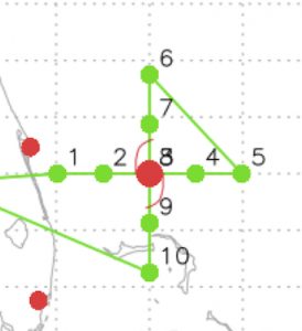
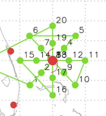
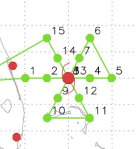
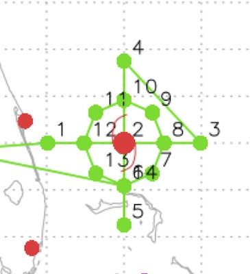
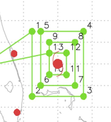
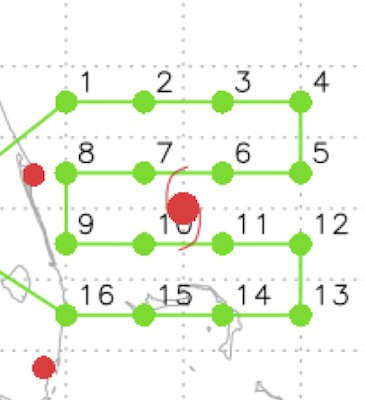
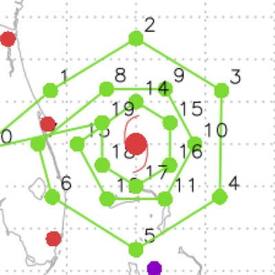
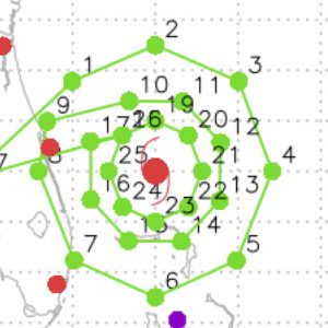
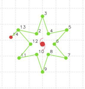
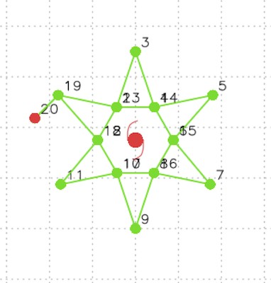
Flight Patterns

Appendices
Aircraft Information
Contact
| Robert (Rob) Rogers
Science Director, Hurricane Field Program 2023