Oceanic, Coastal, and Estuarine Ocean Acidification Observing Networks: North Atlantic Ocean, East and Gulf Coast
SCROLL TO LEARN MORE
What We Do
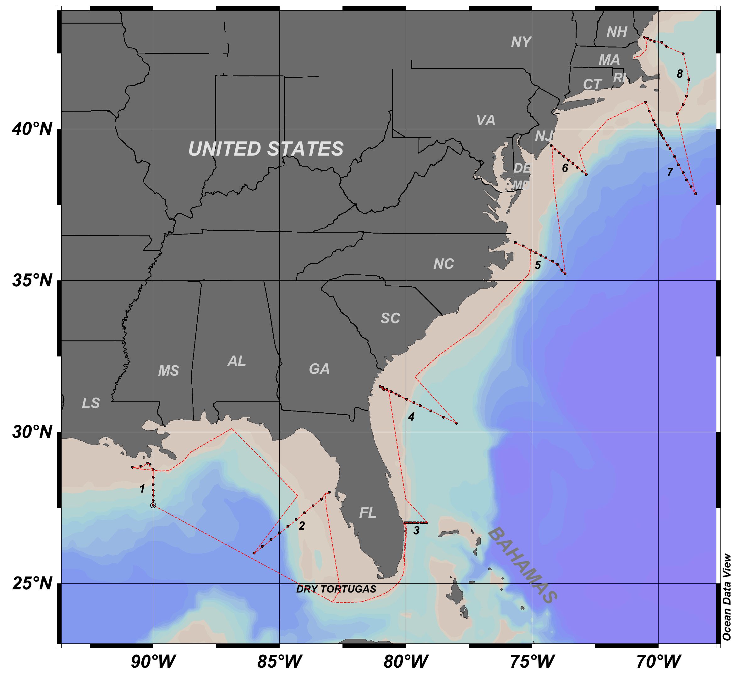
In this project we are developing the North Atlantic Ocean, East and Gulf Coast ocean acidification (OA) observing system in response to the requirements of the Federal Ocean Acidification Research and Monitoring (FOARAM) Act. The observing system will be used to determine patterns and trends in key geochemical indicators of ocean acidification. The observing network of the East and Gulf Coast is based on the following elements:
- Surface water measurements using autonomous systems on six ships of opportunity (SOOP-CO2).
- Dedicated Gulf of America and East Coast Carbon (GOMECC) cruises with surface and subsurface measurements on the NOAA ship Ronald H Brown. This will improve process level understanding of the controls on ocean acidification.
- Moorings with autonomous instruments to determine the rapid temporal changes and causes thereof.
- The continued development of the observing system with new instrumentation and protocols.
The scientific component includes analysis of total alkalinity (TA), dissolved inorganic carbon (DIC), partial pressure of CO2 (pCO2) and pH from samples taken on the cruises and mooring efforts. Data reduction, quality control and data management of the large data sets are a critical component of the observing system. Data products and algorithms to extrapolate the OA indices in time and space are being developed as part of the effort. These cruises provide a data set of physical and chemical coastal ocean parameters that is used both for improved spatial understanding of ocean acidification and to provide a general understanding of changing patterns over time by comparison with previous cruises. The monitoring component is an essential part of the Ocean Acidification Program (OAP), providing a long-term assessment of changes of biogeochemistry and ecology in response to increasing CO2 atmospheric levels and large-scale changes in coastal dynamics.
Who We Are

Background and Key Impacts
Ocean acidification occurs as greater amounts of carbon dioxide (CO2) from atmospheric emissions are absorbed by the oceans, lowering pH levels and making seawater more acidic. Although the ocean’s uptake of CO2 helps to regulate atmospheric CO2 levels, the lower pH negatively impacts a wide range of marine organisms, impairing their ability to thrive. This is causing a fundamental change in the chemistry of the ocean leading to increased acidity which impacts marine life and the people who depend on them. Dedicated SOOP-OA research cruises on the Gordon Gunter and Henry B. Bigelow along with the East Coast Ocean Acidification (ECOA) research cruises and the Gulf of America and East Coast Carbon (GOMECC) research cruises are used to obtain subsurface measurements and a comprehensive suite of biogeochemical observations. PMEL and academic partners maintain three moorings that are also an integral part of the effort.

AOML scientists have led six GOMECC and ECOA cruises in the south Atlantic and Gulf of America gathering valuable data used to provide a comprehensive view of the effects of ocean acidification on coastal ecosystems. These multi-institutional cruises, undertaken in support of NOAA’s Ocean Acidification Program, monitored ocean acidification conditions across the Gulf of America to assess acidification trends and potential impacts to coastal ecosystems. Observations were collected to measure the extent of ocean acidification throughout the Gulf’s water column, as well as key carbon, physical, and biogeochemical parameters.
Scientists from AOML’s Ocean Carbon Cycle group have processed and quality controlled over 1800k underway pCO2 samples from 180 Gordon Gunter and Henry B. Bigelow cruises. The partial pressure of CO2 (pCO2) indicates how much carbon dioxide is in seawater. This data is used to examine ocean carbonate chemistry and biological productivity in the Gulf of America and South Atlantic waters and to provide meaningful projections of future atmospheric CO2 levels and surface oceanic CO2 concentrations in these regions.

Gulf and Ocean Monitoring Ecosystems Coastal Cruises (GOMECC – 5) Cruise
Dates TBD
Chief Scientist,
Personnel Logistics,
Shipping And Cruise Logistics:
Pre – Cruise:
En Route:
Gulf and Ocean Monitoring Ecosystems and Carbon (GOMECC-4) 2021 Cruise
Depart September 12, 2021, Arrive October 21, 2021
Chief Scientist, Leticia Barbero: Leticia.Barbero@noaa.gov,
Co-Chief Scientist, Andrew Stefanick: Andrew.Stefanick@noaa.gov
Personnel logistics, Betty Huss: Betty.Huss@noaa.gov
Shipping and Cruise logistics, Esa Peltola, Esa.Peltola@noaa.gov
East Coast Ocean Acidification Cruise (ECOA – 1, GU-15-04) 2015/2018 Cruise

Personnel Logistics contact Betty Huss: Betty.Huss@noaa.gov
Chief Scientists: Joe Salisbury and Wei-Jun Cai: joe.salisbury@unh.edu, wcai@udel.edu,
Personnel logistics, Betty Huss: Betty.Huss@noaa.gov
Shipping and Cruise logistics, Esa Peltola, Esa.Peltola@noaa.gov
Schedule:
Depart 6/17/2015 Wednesday Newport, RI – Leg 1
Arrive 7/03/2015 Friday Norfolk, VA
Depart 7/08/2015 Wednesday Norfolk, VA – Leg 2
Arrive 7/24/2015 Friday Miami, FL
Post-Cruise
Gulf and Ocean Monitoring Ecosystems and Carbon (GOMECC-3) 2017 Cruise
Depart July 18, 2017, Arrive August 21, 2017
Chief Scientist, Leticia Barbero: Leticia.Barbero@noaa.gov
Personnel logistics, Betty Huss: Betty.Huss@noaa.gov
Shipping and Cruise logistics, Esa Peltola, Esa.Peltola@noaa.gov
OUTREACH
The following links will send you to external sites (listing here does NOT imply U.S. Government endorsement).
Educational institutions which mentioned GOMECC-3 in their communications pages:
- http://news.miami.edu/stories/2017/08/all-aboard-the-carbon-cruise.html
- http://todos.cicese.mx/sitio/noticia.php?n=1004
The communications departments of AOML and the National Park Service published notes on the cruise:
- http://www.aoml.noaa.gov/keynotes/keynotes_0717_gomecc3.html
- https://www.nps.gov/articles/science-at-sea-in-the-gulf-of-mexico.htm
The official cruise blog, to which most of the cruise participants contributed, provided an insider’s view into the science conducted on the cruise and explained it for a non-scientific audience: GOMECC-3 BLOG
As a result of interactions with different communications offices from institutions participating in the GOMECC-3 cruise, several Spanish language newspapers and news outlets from Mexico and Spain reported on the GOMECC-3 project:
- http://www.heraldo.es/noticias/aragon/2017/09/07/una-zaragozana-jacetano-pasan-mes-alta-mar-para-estudiar-acidificacion-oceanica-1195286-300.html#coml
- http://www.elvigia.net/general/2017/7/17/participa-cicese-crucero-noaa-golfo-mexico-lanzan-blog-para-seguir-incidencias-277219.html
- http://www.frontera.info/EdicionEnLinea/Notas/Ensenada/19072017/1237379-Participara-Cicese-en-estudio-del-Golfo-de-Mexico.html
- http://www.cronica.com.mx/notas/2017/1035582.html
- http://www.uniradioinforma.com/noticias/ensenada/488030/cicese-en-crucero-de-la-noaa.html
- https://www.inforural.com.mx/mexico-cuba-y-eu-inician-investigacion-sobre-la-acidificacion-del-golfo-de-mexico/
- http://www.mexicoambiental.com/v2/cientificos-mexicanos-abordan-crucero-cientifico-la-noaa-estudiar-golfo-mexico/
PRE-CRUISE
- Station Locations
- Cruise Participants
- Foreign National Security Forms
- NOAA Health Services Questionnaire Form
- Emergency Contact Information Form
DURING CRUISE
POST-CRUISE
Access to Naval Base
East Coast Ocean Acidification Cruise (ECOA – 2) 2015 

East Coast Ocean Acidification Cruise
Expocode: 33HH20180625
Project ID: OAP1812-1527
Chief Scientists: Joe Salisbury and Wei-Jun Cai: joe.salisbury@unh.edu, wcai@udel.edu
Schedule:
Depart 6/25/2018 Newport, RI
Arrive 7/29/2018 Miami, FL
Gulf and Ocean Monitoring Ecosystems and Carbon (GOMECC-2) 2012 Cruise
(RB 12-03)
July 21, 2012 – August 13, 2012

Personnel logistics, contact Betty Huss: Betty.Huss@noaa.gov
Shipping and Cruise logistics, Esa Peltola, Esa.Peltola@noaa.gov
Pre-Cruise
Foreign National Security Forms
NOAA Health Services Questionnaire Form
Emergency Contact Information Form
During-Cruise
Movie Clip of the Cruise
The movie clip was produced by Mr. Bruce Cowden, Chief Bosun, NOAA Ship Ronald H. Brown.
Madalyn Meaker’s Blog
“My Experience as a Marine Science Undergraduate on a NOAA Research Cruise”
Post-Cruise
Andrew Margolin’s Blog
“My Month At Sea Sampling Coastal Waters with NOAA”
Gulf and Ocean Monitoring Ecosystems and Carbon (GOMECC-1) 2010 Cruise
(RB 07-05)

Partners

