|
Subject: H7) How does the ocean respond to a hurricane and how does this feedback to the storm itself? Contributed by Joe Cione (HRD)
The ocean's primary direct response to a hurricane is cooling of the sea surface temperature (SST). How does this occur? When the strong winds of a hurricane move over the ocean they churn-up much cooler water from below. The net result is that the SST of the ocean after storm passage can be lowered by several degrees Celsius (up to 10° Fahrenheit).
One important caveat to realize however is that most of the 3-5°C (6-9°F) ocean cooling shown in Figure 1 occurs well after the storm has moved away from the region (in this case several days after Georges made landfall). The amount of ocean cooling that occurs directly beneath the hurricane within the high wind region of the storm is a much more important question scientists would like to have answered. Why? Hurricanes get their energy from the warm ocean water beneath them. However, in order to get a more accurate estimate of just how much energy is being transferred from the sea to the storm, scientists need to know ocean temperature conditions directly beneath the hurricane. Unfortunately, with 150kph+ (100mph+) winds, 20m+ (60ft+) seas and heavy cloud cover being the norm in this region of the storm, direct (or even indirect) measurement of SST conditions within the storm's "inner core" environment are very rare. Thankfully in this case "very rare" does not mean "once in a lifetime". Recently, scientists at the Hurricane Research Division were able to get a better idea of how much SST cooling occurs directly under a hurricane by looking at many storms over a 28 year period. By combining these rare events, HRD scientists put together a "composite average" of ocean cooling directly under the storm.
While the estimates in Figure 2 represent a dramatic improvement when it comes to more accurately representing actual SST cooling patterns experienced under a hurricane, even small errors in inner core SST can result in significant miscalculations when it comes to accurately assessing how much energy is transferred from the warm ocean environment directly to the hurricane. With all other factors being equal, being "off" by a mere 0.5°C (1°F) can be the difference between a storm that rapidly intensifies to one that falls apart! With that much at stake, scientists at HRD and other government and academic institutions are working to improve our ability to accurately estimate, observe and predict "under-the-storm" upper ocean conditions. These efforts include statistical studies, modeling efforts and enhanced observational capabilities designed to help scientists better assess upper ocean thermal conditions under the storm. With such improvements, it is believed that future forecasts of tropical cyclone intensity change will be significantly improved.
Reference Last updated August 13, 2004 Back to Tropical Cyclone Observation Page | Back to Main FAQ Page |
TC FAQ
Links of Interest
AOML Tools & Resources
Employee Tools
Stay Connected
|

| ||
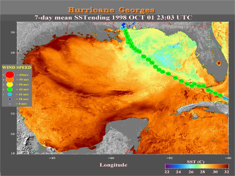 Figure 1
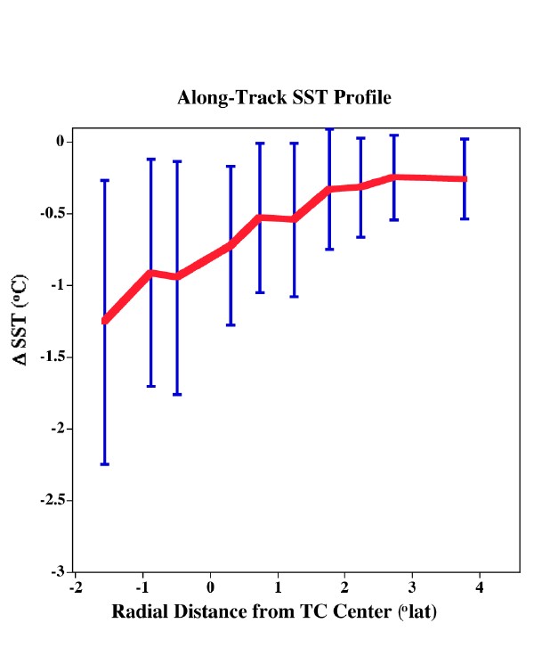 Figure 2