
Back to Tropical Cyclones
Forecasting Page | Back
to Main FAQ Page
Subject: F8) How is storm surge observed and measured?
Contributed by the NHC Storm Surge Unit
There are several methods used by NOAA, the United States Geological
Survey (USGS), and the Federal Emergency Management Agency (FEMA) to
measure storm surge. Each method has advantages and draw backs and
post-storm analysis of storm surge requires resolving differences in
what each measures to find the best approximation of the surge heights.
-
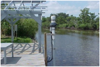
Tide Stations (NOAA)
A network of 175 long-term, continuously operating water level stations
located throughout the U.S. serving as the foundation for NOAA's tide
prediction products.
- Measures still water (e.g. no waves)
- Traditionally the most reliable method
- Limited, fixed stations
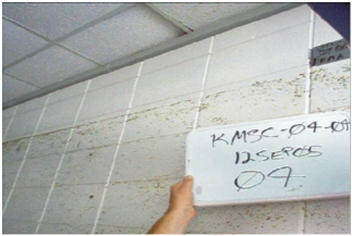
- High Water Marks (USGS / FEMA)
These are the lines left on trees and structures marking the highest
(peak) elevation of the water surface from a flood event. They are created
by foam, seeds, and other debris. Survey crews deploy after a storm, locate,
and record reliable high water marks. GPS methods are used to determine
the location of these marks, which are then mapped relative to a
vertical reference datum.
- Perishable
- Traditionally best method for capturing highest surge level
- Subjective and often includes impact of waves
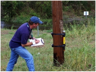
- Pressure Sensors (USGS)
These are temporary water-level and barometric-pressure sensors which
provide information about storm surge duration, times of surge arrival and
retreat, and maximum depths.
- Relatively new method
- Mobile, deployed in advance of storms at expected location of
highest surge
- Can contain impact of waves
Last updated May 14, 2010
Back to Tropical Cyclones
Forecasting Page | Back
to Main FAQ Page
|
