Back to Hurricane Intensity Change projects
|
Back to Main Projects Page
Saharan Air Layer
Principle Investigator : Jason Dunion (HRD)
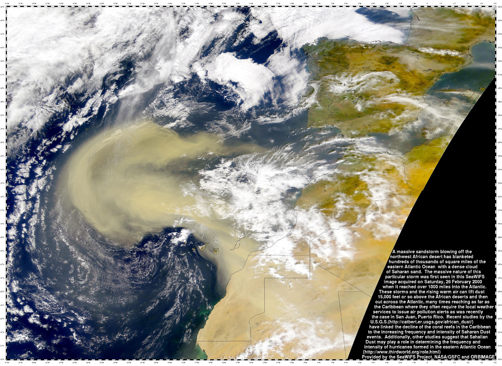
SeaWiFS/NASA/GSFC
Team Members:
Sim Aberson (HRD)
Mike Black (HRD)
Neal Dorst (HRD)
Jeff Hawkins (NRL)
John Kaplan (HRD)
Chris Landsea (HRD)
Paul Leighton (HRD)
Frank Marks (HRD)
Mark Powell (HRD)
Rob Rogers (HRD)
Joseph Prospero (UM/CIMAS)
Chris Velden (UW/CIMSS)
Objectives:
- Improve our understanding of the mechanisms by which the Saharan Air
Layer's (SAL's) dry air, mid-level easterly jet, and embedded mineral dust
affect Atlantic tropical cyclone genesis and intensity change;
- Include the moisture information from the GPS dropwindsondes in operational
parallel runs of the NOAA Global Forecast System (GFS) model. Assess the
impact of this data on the GFS (and GFDL) initial/forecast humidity fields and
its forecasts of TC track and intensity;
- Improve the representation of the SAL's dry air and mid-level easterly jet
(enhanced vertical wind shear) in forecast models;
- Implement a new total precipitable water (TPW) predictor in the SHIPS model
to help account for the impact of dry layers (e.g. the SAL and mid-latitude dry
air intrusions) on tropical cyclone intensity.
- Investigate how the SAL interacts with the tropical cyclone inner core;
- Improve our understanding of the SAL's vertical structure;
- Investigate the mechanisms that lead to strong SAL outbreaks over Africa;
- Investigate the mechanisms by which the SAL maintains its thermodynamic
structure;
- Investigate the effect of the SAL's suspended mineral dust on cloud
microphysics;
Methods:
- Conduct the SALEX experiment using NOAA's P-3 Orion and G-IV aircraft as
described in the HRD hurricane field program (HFP);
- SAL monitoring: GOES, MSG, SSM/I, AMSR-E, Aqua and Terra satellites
- SAL sampling: GPS dropsondes;

Dust layer associated with the Saharan Air Layer. Photo taken from the NOAA
G-IV northeast of Barbados during SALEX mission 20060916n. Cumulus clouds can
be seen poking through the tops of the dust layer, which is seen as a milky
white haze. Photo credit: Jason Dunion NOAA/HRD.
Accomplishments:
- Developed automated geostationary satellite imagery (GOES-10 and
Meteosat-9) to track the SAL continuously. These new products include split
window IR, mid-level water vapor, and multi-spectral true color satellite
imagery and are available in real-time at the UW-CIMSS tropical cyclone
website:
http://cimss.ssec.wisc.edu/tropic/real-time/wavetrak/sal.html
- Conducted first-ever SALEX missions during the 2005 Atlantic hurricane
season that used the NOAA G-IV jet to investigate the environments of TS Irene
and pre Tropical Depression 19 and their interactions with the SAL:
- Aug. 07, 2005 (G-IV jet)
- Aug. 08, 2005 (G-IV jet)
- Sept. 27, 2005 (G-IV jet)
- Sept. 27, 2005 (G-IV jet)
- Successfully submitted a proposal to the NOAA/Joint Hurricane Testbed
program to assimilate moisture information from GPS dropsondes launched from
the NOAA G-IV jet in operational parallel runs of the NOAA GFS model and assess
the impact of this data on the GFS initial/forecast humidity fields and its
forecasts of TC track and intensity. This JHT project began in 2005 and ended
in early 2007 and results from this work led to a decision by NOAA/NCEP to
begin routinely assimilating humidity data from GPS dropsondes into the
operational version of the GFS model (beginning 22 August 2006).
- Conducted SALEX missions during the 2006 Atlantic hurricane season that
used the NOAA P-3 Orion and G-IV jet to investigate the environments of
Tropical Storm Debby and Hurricane Helene and their interactions with the SAL:
-
Aug. 25, 2006 (G-IV jet)
-
Aug. 26, 2006 (G-IV jet)
-
Sep. 15, 2006 (G-IV jet)
-
Sep. 16, 2006 (G-IV jet)
-
Sep. 18, 2006 (P-3 Orion;
G-IV jet)
-
Sep. 20, 2006 (P-3 Orion;
G-IV jet)
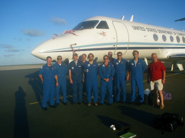
G-IV flight crew in Barbados after the 26 August 2006 Tropical Storm Debby
SALEX mission. From left to right are: Chuck Rasco, Mission Flight Director,
Jeff Hawkins, Jeff Smith, Sim Aberson, Michele Finn, Dale Carpenter, John
Longenecker, Jason Dunion, and Gordon Kitson. Photo credit: Jack Parrish
NOAA/AOC.
References:
Dunion, J.P., and C.S. Marron, 2007: A Reexamination of the Jordan mean
tropical sounding based on awareness of the Saharan Air Layer: Results from
2002. J. Climate. (Accepted).
Jones, T., D. Cecil, and J.P. Dunion, 2007: The environmental and inner core
conditions governing the intensity of Hurricane Erin (2001). Wea. Forecast.
24 no. 4, 708-725.
Evan, A.T., J. Dunion, J.A. Foley, A.K. Heidinger, and C.S. Velden, 2006: New
evidence for a relationship between Atlantic tropical cyclone activity and
African dust outbreaks. J. Geophys. Res. 33 L19813, 1-5.
Dunion, J.P., and S.D. Aberson, 2007: Assimilating moisture information from
Global Positioning System (GPS) dropwindsondes into the NOAA Global Forecast
System, 61st Annual Interdepartmental Hurricane Conference,
New Orleans, LA, Office of Fed. Coord. For Meteor. Services and Supporting
Research, NOAA.
Dunion, J.P., J.D. Hawkins, and C.S. Velden, 2006: Hunting for Saharan Air
with the NOAA GI-IV Jet. AMS 27th Conference on Hurricanes and Tropical
Meteorology, Monterey, CA, American Meteorological Society.
Dunion, J.P., C.S. Velden, J.D. Hawkins, and J.R. Parrish, 2004: The Saharan
Air Layer- Insights from the 2002 and 2003 Atlantic hurricane seasons. AMS
26th Conference on Hurricanes and Tropical Meteorology, Miami, FL,
American Meteorological Society, 495-496.
Dunion, J.P., and C.S. Velden, 2004: The impact of the Saharan Air Layer on
Atlantic tropical cyclone activity. Bull. Amer. Meteor. Soc., 85
no. 3, 353-365.
Dunion, J.P., and C.S. Velden, 2003: The Impact of the Saharan Air Layer on
Atlantic tropical cyclones. 57th Annual Interdepartmental
Hurricane Conference. Miami, FL, Office of Fed. Coord. For Meteor.
Services and Supporting Research, NOAA.

Photo of the Saharan Air Layer taken from the NOAA P-3 Orion after SALEX
mission 20060918h during the ferry back to Barbados. Saharan dust gives the
sky an orange glow during this late afternoon sunset in the eastern Caribbean.
Small cumulus clouds can be seen poking through the tops of the dust layer.
Photo credit: Jason Dunion NOAA/HRD.
Future Work:
- Conduct additional SALEX missions during future NOAA HRD hurricane field
programs that utilize the NOAA P-3 Orion and G-IV aircraft. These research
missions will be designed to address the main objectives described above.
- Continue to assess the impact of humidity data from the GPS dropsondes
launched from the NOAA G-IV jet on the NOAA GFS ad GFDL models. Specific goals
will include continued assessment of the impact of the GPS dropsondes on GFS
and GFDL initial/forecast humidity fields and their forecasts of TC track and
intensity;
- Develop a new mean Jordan tropical sounding (dry SAL vs moist non-SAL) that
is based on 8 years of Caribbean rawinsonde data;
- Implement an improved humidity parameter (TPW) for routine use in the SHIPS
hurricane intensity forecast model;
Back to Hurricane Intensity Change projects
|
Back to Main Projects Page
Last modified: 11/04/2007
