Back to Intensity Change projects
|
Back to Main Projects Page
Probabilistic Rapid Intensification (RI) Forecasts in the
Atlantic and E. Pacific Basins
Principal Investigator:
John Kaplan
Collaborating scientist:
Mark DeMaria (NOAA/NESDIS/ORA)
Methodology:
The OAR has identified obtaining guidance on the
timing and magnitude of episodes of rapid intensification (RI) as one of
the highest operational tropical cyclone forecasting priorities. In an
effort to provide a tool to aid in the forecasting of rapid
intensification, an updated index for estimating the probability of rapid
intensification (Kaplan and DeMaria 2003) has been developed as part of
the NOAA Joint Hurricane Testbed. The rapid intensification index employs
5 large-scale and 2 satellite-derived inner-core predictors from the
SHIPS model (DeMaria et al., 2005) to estimate the probability of
rapid intensification for the 24-h period commencing at t=0. The
2006 version of the rapid intensification index differed from that
used in previous seasons in a few areas. First, the threshold for
rapid intensification was lowered
slightly from a maximum sustained wind increase threshold of ≥ 30 kt in
24 h to a threshold of ≥ 25 kt in 24 h. Also, the methodology for deriving
the index was modified so that that the contributions from each of the rapid
intensification predictors represented a scaled value between 0 and 1 rather
than simply a 0 or 1 as had been employed in the previous version of the index.
Finally, a second version of the RI index was derived using predictor values
that were weighted utilizing linear discriminant analysis (Wilks 1995). A
more complete description of the methodology used to derive the 2006 rapid
intensification index can be found in Kaplan and DeMaria (2006).
Results

|
| Figure 1
|
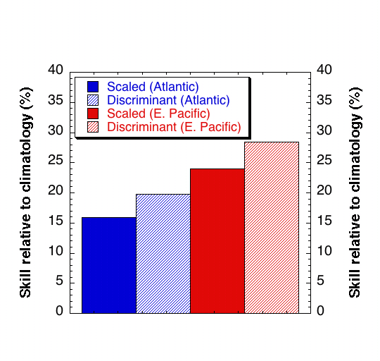
Figure 1 shows the skill of the RI index for the 1995-2005 Atlantic and
E. Pacific dependent samples. The skill shown in Fig. 1 was computed
relative to climatology using brier skill scores where positive values
indicate skill relative to climatology and negative values denote skill
that is less than that of climatology. The figure indicates that the E.
Pacific version of the index exhibits more skill than the Atlantic
version and that the discriminant version of the index outperforms the
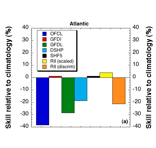
scaled version. Figure 2 shows the skill of the independent RI index
forecasts that were provided to the OAR in
real-time during the 2006 hurricane. For comparison, the figure also
shows the skill of the other operational deterministic intensity guidance
as well as the official NHC forecast. To compute the skill of each of the
deterministic models and the official NHC forecasts it was necessary to
assign a probability to each forecast. This was accomplished by assigning
either a probability of 100% or 0% to each case based upon the forecasted
intensity change. To illustrate, a probability of 100% (0)% was assigned
when the forecasted 24-h intensity change was ≥ (≤) the RI
threshold of 25 kt. Figure 2 indicates that while the scaled version of

| 
|
| Figure 2
|
the RI index had slightly more skill than either SHF5 or GFDI models;
none of the objective guidance performed very well in the Atlantic basin.
Also, in contrast to the results shown in Fig. 1 the discriminant version
was significantly worse than the scaled version and climatology. However,
both the scaled and discriminant versions of the RI index performed quite
well for the E. Pacific basin with the discriminant version providing the
most skillful RI forecast guidance. The only operational model that
showed skill relative to climatology was the GFDL model which exhibited a
small amount of skill for this basin. Interestingly, the official NHC
forecasts (OFCL) exhibited considerable skill in the E. Pacific basin
even though the deterministic models themselves exhibited only slight
skill or no skill relative to climatology. One reason for this may be the
relatively good performance of the RI index in the E. Pacific since the
RI index was provided to forecasters in real-time during the 2006 season.
It is worth noting that the comparatively poor (good) performance of the
RI index and to a certain extent the deterministic models in the Atlantic
(E. Pacific) during the 2006 hurricane season can be partly explained by
the less (more) than normal activity in the Atlantic (E. Pacific) basins
since climatology is a tougher (easier) forecast to beat in less (more)
active years. To illustrate, only 6% of the 2006 Atlantic cases rapidly
intensified compared to the climatological average of 12% while 16% of
the 2006 E. Pacific cases rapidly intensified compared to the
climatological mean of 11%.
FY06-07 Achievements
- An updated scaled version of the RI index was tested in real-time at the
OAR (NHC) during the 2005 Atlantic and E. Pacific
hurricane season
- The performance of the RI index was evaluated for an independent sample
of storms from the 2004 and 2005 Hurricane seasons and the results were
presented at the 27th Conference on Hurricanes and Tropical Meteorology.
- The new scaled version of the RI index was officially adopted for
Operational use in the Atlantic and E. Pacific basins by the NHC in June
of 2006
- A new discriminant version of the RI index was run in real-time during
the 2006 Atlantic and E. Pacific Hurricane season.
- The RI index performance during the 2006 Atlantic and E. Pacific
Hurricane seasons was evaluated and the results were presented
at the 2007 Interdepartmental Hurricane Conference.
FY07-08 Milestones
- Run the RI index and provide output to the NHC in real-time during the
2007 and 2008 Atlantic and E. Pacific hurricane seasons.
- Evaluate RI index performance and modify as necessary to improve future
performance
- Submit manuscript describing the updated version of the RI index
- A revised version of the original SHIPS rapid intensity index (RII) was
developed for the Atlantic and East Pacific basins as part of the NOAA Joint
Hurricane Testbed (JHT). The revised RII uses predictors from the Statistical
Hurricane Intensity Prediction Scheme (SHIPS) to estimate the probability of
rapid intensification (RI) for 3 different RI thresholds (25,30, and 35 kt)
utilizing linear discriminant analysis. The RII was declared operational by the
NHC prior to the 2008 Hurricane Season.
Key references:
Kaplan, J. and M. DeMaria, 2006: Estimating the likelihood of rapid
intensification in the Atlantic and E. Pacific basins using SHIPS model
data, Preprints 27th Conference on Hurricanes and Tropical
Meteorology , Monterey, CA, Amer. Meteor. Soc..
Kaplan, J., and M. DeMaria, 2003: Large-scale characteristics of rapidly
intensifying tropical cyclones in the North Atlantic basin. Wea.
Forecasting, 18, 1093-1108.
DeMaria, M., M. Manelli, L.K. Shay, J.A. Knaff, and J. Kaplan,
2005: Further improvements to the Statistical Hurricane Intensity
Prediction Scheme (SHIPS), Wea. Forecasting, 20, 531-543.
Wilks, D.S., 1995: Statistical Methods in the Atmospheric Sciences,
Academic Press, 467pp.
Back to Intensity Change projects
|
Back to Main Projects Page
Last Modified : May 4, 2007


