|
Hurricane Guillermo Case StudyPrincipal Investigators: Matt Eastin (HRD) Team Members: John Gamache (HRD)
Objectives of group:
Methods: We will approach these objectives through a combination of extensive observational analysis as well as idealized and "full physics" numerical simulations.
OBSERVATIONAL ANALYSIS On both days, coordinated flight patterns and radar scanning strategies allowed the construction of 3D wind fields for 10 separate time periods over a 6 hour span, providing unprecedented temporal coverage. The 3D wind fields were constructed by mapping the Doppler radial velocity data from each aircraft onto grids and then applying a variational solution technique. Vertically incident radar fields (vertical velocity and reflectivity) are available for 6 of the 10 eye penetrations each day. Flight-level data from both aircraft are available each day, although reliable thermodynamic data is available from only one aircraft. [The standard in situ temperature and humidity observations suffer from wetting errors in and near convection. Only through the use of temperatures measured by a radiometer thermometer can accurate estimates of thermodynamic quantities in the eyewall be made.] On 3 August, GPS dropwindsondes were successfully deployed in the eyewall for the first time. Combined with sondes deployed in the eye and outside the eyewall on both days, the GPS data provide unprecedented high-resolution kinematic and thermodynamic observations below flight level to the surface. These inner-core observations are used to diagnose the 3D kinematic, dynamic, and thermodynamic mesoscale and convective-scale structure and evolution of the eyewall in Hurricane Guillermo. The inner-core observations will be complimented with AVN operational analyses in order to diagnose the impact of the synoptic-scale environment upon inner-core convective organization. NUMERICAL MODELING: Numerical simulations using a primitive equation model with a representation of moist physical processes, e.g. the WRF model, will be employed to compliment the observational study. Specifically we will focus on issues pertaining to the low azimuthal wavenumber modulation of eyewall convection and the impact of convective asymmetry on the upper circulation of the hurricane.
Accomplishments:
References:
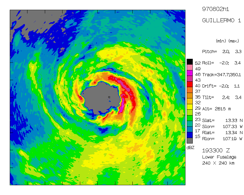 Figure 1 Storm-relative radar reflectivity for Hurricane Guillermo at 1933 UTC on 2 August 1997 at 2.8 km altitude. The domain is 240 km x 240 km with tic marks shown every 24 km. Note the polygonal boundary between the eye and eyewall.
 Figure 2 An east-west vertical cross section of radar reflectivity across the eye and eyewall of Hurricane Guillermo at 1933 UTC on 2 August 1997. The domain is 20 km x 120 km with tic marks shown every 2 km in the vertical and every 12 km in the horizontal.
Last modified: 11/04/2003 |
Links of Interest
AOML Tools & Resources
Employee Tools
Stay Connected
|

| ||