The Lower Fuselage (LF) radar animations are produced by
HRD/AOML/NOAA. The data is collected aboard NOAA's WP-3D
turboprops. The animations consist of a series of LF
sweeps. The LF sweeps have the descriptor .swp and follow
the internal HRD composite format convention. There is one
.swp file per LF sweep. The sweeps are stored as 2 dimensional
binary files. The files are written with Fortran90
software. Click here for Fortran90
software to read the data. Click here
for MatLab function to read the data. LF sweeps are either plane
relative, with the plane position in the middle of the Cartesian
map; or storm relative, with the storm position in the middle
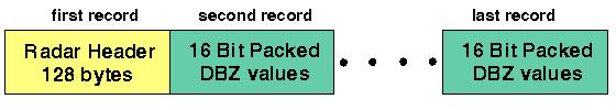
of the Cartesian map. The first record on the files is the
radar header containing 128 bytes of general information.
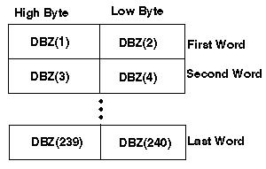
Followed by16 bit packed words containing dbz values:
The dbzs are packed 2 per word. The overall range of the data
is from -31.5 dbz to +95.5 dbz in half db steps. The
no data flag is
-999.0. Note that these bytes are packed into words with the
first byte going into the high byte of the first word:
What follows is a description of the
information on the Radar Header. The column on the left contains
variable types and sizes, the column in the middle describes the
variable contents, and the right column shows sample values from the
Frances N43RF flight on August 30, 2004.
-30 WORDS CHARACTER-
|
| Size |
Content |
Example |
character*4
|
identifies the file type
|
swp
|
character*8
|
flight identification: yrmodyID
42 plane ID is the "h"
43 plane ID is the "i"
|
040830I1
|
character*12
|
storm or project name
|
Frances |
character*4
|
radar identifier:
"LF"lower fuselage
"TAIL"tail&doppler
"LB"land based
|
LF
|
character*32
|
comment, the track file name if one was used
|
none
|
character*32
|
time file was created
|
Mon, Dec 6, 2004, 02:06:01 PM
|
character*28
|
the flight level file name if one was used
|
none
|
| -10
WORDS INTEGER- |
| Size |
Content |
Example |
|
1:integer*4 |
x horizontal dimension on the 3d Cartesian Plane in bins
|
240 |
|
2:integer*4 |
y vertical dimension on the 3d Cartesian Plane in bins
|
240 |
| 3:
integer*4 |
z height or level
on the 3 dimensional Cartesian Plane
| 1 |
| 4:
integer*4 |
number of sweeps
on the composite display
| 1 |
| 5:
integer*4 |
flag:
-1 center plane relative
0 center earth relative
1 center storm relative
| -1 |
| 6:
integer*4 |
flag:
0 for folded Doppler radar values
1 for unfolded Doppler radar values
| 0 |
| 7:
integer*4 |
flag:
0 intervening attenuation is off
1 intervening attenuation is on
| 0 |
8: integer*4
|
flag:
Bit 0 = 0 unedited Doppler file, 1 edited Doppler file
Bit 1 = 0 vt not added to file, 1 vt added to file
Bit 2 = 0 Joss &Waldvogel vt, 1 Willis vt
|
0 |
9: integer*4
|
spare
| 0
|
10:integer*4
|
spare
| 0
|
-24 WORDS REAL-
|
| Type |
Content |
Units |
Example |
1: real
|
start time of the Cartesian plane
*24 hours are added for flight times after midnight* |
(seconds) |
65450.81 |
2: real
|
end time of the Cartesian plane
*24 hours are added for flight times after midnight* |
(seconds) |
65482.76 |
3: real
|
reference for
latitude position |
(degrees) |
19.40 |
4: real
|
reference for
longitude position |
(degrees) |
-59.46
|
5: real
|
x scale resolution |
(kilometer/bin) |
1.50 |
6: real
|
y scale resolution |
(kilometer/bin) |
1.50 |
7: real
|
z scale resolution |
(kilometer/level) |
0.50
|
8: real
|
x or horizontal
distance with respect to the origin |
(kilometer) |
180.00 |
9: real
|
y or vertical
distance with respect to the origin |
(kilometer) |
180.00 |
10:real
|
z distance of
first level or standard dev. of track for cross section |
(km)
| 0.00
|
11:real
|
rotation angle
or average track for cross section |
(degrees)
| 0.00 |
12:real
|
radar altitude
| (meters) |
2773.00 |
13:real
|
calibration
coefficient 1 |
(1/16 dbZ) |
-27.13 |
14:real
|
calibration
coefficient 2 |
(1/4096 of dbZ) |
0.33 |
15:real
|
azimuth correction |
(degrees) |
0.00 |
16:real
|
elevation
correction |
(degrees) |
0.00 |
17:real
|
dbz noise
threshold |
(dbz) |
-99.00
(no threshold used) |
18:real
|
peak power
or dbz range for thresholding
| (kw) or (km)
| -99.00
(not used) |
19:real
|
pitch correction
| (degrees) |
0.00 |
20:real
|
drift
correction |
(degrees) |
0.00 |
21:real
|
roll
correction |
(degrees) |
0.00 |
22:real
|
maximum range of
the radar |
(kilometer) |
384.00 |
23:real
|
spare for
LF, height of the bright band for TAIL; |
(km) |
0.00 |
24:real
|
spare for LF, depth of the
bright band |
(km) |
0.00 |
FILE TYPE DESCRIPTORS
|
"CMP "
|
LF composite
|
"TA3D"
|
TAIL 3 dimensional
|
"DOP3
|
Doppler 3
dimensional
|
"WIND"
|
Wind 3 dimensional
|
"XSEC"
|
TAIL cross section
|
"SWP "
|
LF single sweep
|
|