|
Tropical Storm Chantal (16-20 August 2001)
The goal of this mission was to obtain coordinated multi-level in situ and remotely sensed observations to support the Quantitative Precipitation Estimation (QPE) objectives of CAMEX-4 under t he USWRP. We hoped to sample the precipitation features in the core rainbands at three altitudes and to attempt to focus our remote sensing and in situ precipitation measurement capabilities on any major precipitation feature. 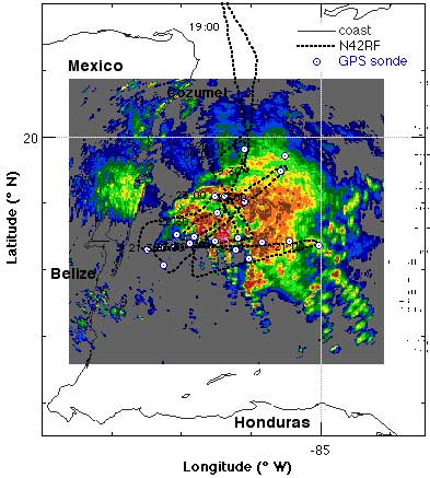 N42RF surveyed the convective features primarily in Chantal's northern and eastern quadrants in the middle troposphere up to approximately 21/0000 UTC, or 1.5 hours before
landfall. The flight level center was about 15-25 nmi to the NE of the Air Force's WC-130 aircraft fixes at 5,000 ft. The major convection was 20-30 km NE of the center of circulation. 20 GPS sondes were dropped and 18 with good winds were transmitted GPS
-sonde messages were received at NHC. Doppler radar data were collected throughout the mission. The SFMR did not work for this mission.
N42RF surveyed the convective features primarily in Chantal's northern and eastern quadrants in the middle troposphere up to approximately 21/0000 UTC, or 1.5 hours before
landfall. The flight level center was about 15-25 nmi to the NE of the Air Force's WC-130 aircraft fixes at 5,000 ft. The major convection was 20-30 km NE of the center of circulation. 20 GPS sondes were dropped and 18 with good winds were transmitted GPS
-sonde messages were received at NHC. Doppler radar data were collected throughout the mission. The SFMR did not work for this mission.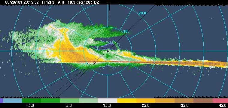 The
NASA DC-8 and ER-2 pattern mirrored that of N42RF except with
longer legs to compensate for their faster ground speed. The DC-8
dropped 6 GPS sondes and transmitted them to NCEP. The
NASA DC-8 and ER-2 pattern mirrored that of N42RF except with
longer legs to compensate for their faster ground speed. The DC-8
dropped 6 GPS sondes and transmitted them to NCEP.
|
Links of Interest
AOML Tools & Resources
Employee Tools
Stay Connected
|

| ||