|
Hurricane Gabrielle (13-16 September 2001) 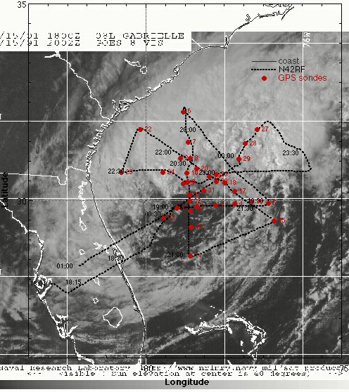 A
very good set of missions! Good coordination with the groundbased
radars and the research aircraft. Storm structure was very interesting
as it got organized on the 13th, made landfall on the W coast
of FL on the 14th, and became entangled with a mid-latitude trough.
At landfall the storm intensified rapidly and the mobile groundbased
radars were able to document a mesocyclone signature near the
center of circulation and 35 m s-1 w inds at 1-2 km altitude. A
very good set of missions! Good coordination with the groundbased
radars and the research aircraft. Storm structure was very interesting
as it got organized on the 13th, made landfall on the W coast
of FL on the 14th, and became entangled with a mid-latitude trough.
At landfall the storm intensified rapidly and the mobile groundbased
radars were able to document a mesocyclone signature near the
center of circulation and 35 m s-1 w inds at 1-2 km altitude.
 On the 15th the storm moved off the east coast of Florida and was
reorganizing despite ingestion of dry air into the circulation.
The storm stucture had little deep convection, with the only d
eep convective features NE of the center about 120 nm from the
center where the cloud tops were near 15 km and the reflectivity
was near 50 dBZ. The surface circulation was well S and E of the
flight-level center (20-25 nm). The region S and E of the cent
er was very dry with only small convective clouds. However, the
sea state S and E of the center indicated a region of strong surface
winds 18-25 m s-1 surrounding a broad center 50 nm across. It
appeared the storm was moving right over the Gulf Stream axis.
AXBTs revealed that the SST was running between 28.5-29.0 C over
a large domain that the storm was over. By the time we left the
storm the convection was getting more vigorous and it appeared
the storm was much better organized than when we arrived, certainly
deserving tropical storm status. This flight represents the best
documentation of a reintensifying tropical storm.
On the 15th the storm moved off the east coast of Florida and was
reorganizing despite ingestion of dry air into the circulation.
The storm stucture had little deep convection, with the only d
eep convective features NE of the center about 120 nm from the
center where the cloud tops were near 15 km and the reflectivity
was near 50 dBZ. The surface circulation was well S and E of the
flight-level center (20-25 nm). The region S and E of the cent
er was very dry with only small convective clouds. However, the
sea state S and E of the center indicated a region of strong surface
winds 18-25 m s-1 surrounding a broad center 50 nm across. It
appeared the storm was moving right over the Gulf Stream axis.
AXBTs revealed that the SST was running between 28.5-29.0 C over
a large domain that the storm was over. By the time we left the
storm the convection was getting more vigorous and it appeared
the storm was much better organized than when we arrived, certainly
deserving tropical storm status. This flight represents the best
documentation of a reintensifying tropical storm. 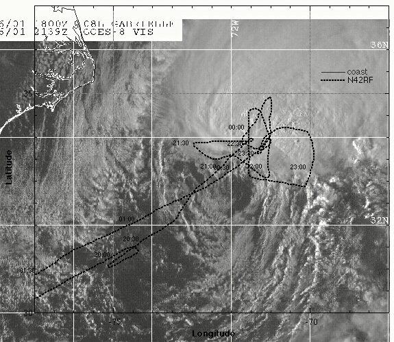 On the 16th the storm was better organized as it raced to the NE
passing between Cape Hatteras and Bermuda. The storm structure
was much better organized that the previous data, with intense
c onvection still to the NE of the center, but closer to the center.
The major rainband was also closer to the storm center, but there
was still significant tilt to the vortex with a 20 nm displacement
from the surface center to the flight level center at 1 4 kft.
During the flight a new center seemed to be forming closer to
the convection and our last center drop actually recorded hurricane
force winds near the surface. Coordinated legs were flown with
N42RF and the ER-2 through the deep convection NE of th e center,
followed by some spirals dropping GPS sondes along the inside
and outside of the major rainband.
On the 16th the storm was better organized as it raced to the NE
passing between Cape Hatteras and Bermuda. The storm structure
was much better organized that the previous data, with intense
c onvection still to the NE of the center, but closer to the center.
The major rainband was also closer to the storm center, but there
was still significant tilt to the vortex with a 20 nm displacement
from the surface center to the flight level center at 1 4 kft.
During the flight a new center seemed to be forming closer to
the convection and our last center drop actually recorded hurricane
force winds near the surface. Coordinated legs were flown with
N42RF and the ER-2 through the deep convection NE of th e center,
followed by some spirals dropping GPS sondes along the inside
and outside of the major rainband.The analysis of these flight will prove very useful in diagnosing how a storm gets better organized out over open water with relatively high SSTs. The phenomenal GSP sonde coverage over such a large area from N42RF, DC-8, and G-IV, combined with the A XBT coverage will provide a great data set for air-sea interaction and trough interaction studies of a slowly intensifying storm.
|
Links of Interest
AOML Tools & Resources
Employee Tools
Stay Connected
|

| ||