
This study shows how weak, disorganized tropical cyclones that have different center locations with height (misalignment) can develop a vertically aligned structure. The ability to predict whether and when a tropical cyclone will become aligned is important for intensity change forecasts, as storms can intensify quickly after achieving it. This study will help improve forecasts of when this might occur by identifying key times of the day and other characteristics of the tropical cyclone when alignment is likely.
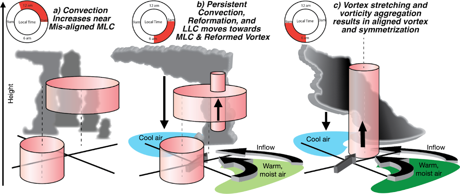 Figure. Schematic demonstrating the processes responsible for alignment. Panel a) shows the low-level center (LLC, pink cylinder bottom left) displaced from the mid-level center (MLC, pink cylinder above and to the right) with thunderstorms increasing near the MLC (indicated by the tall, grey clouds). The increasing thunderstorms near the MLC occur during the overnight to early morning hours of 11 pm – 3 am local time (panel a, upper left). At 3 am–6 am local time (panel b), the boundaries between cooler air from thunderstorm downdrafts (light blue shading) and warm, unstable air (light green shading) collide and initiate more persistent thunderstorms. A new, compact low-mid level center forms near these thunderstorms and causes inflow that brings warm, moist air (light green shading) toward the new center fueling more thunderstorms. This inflow also causes the LLC to rapidly move towards the new center as moisture increases. By panel c), 6 am–9 am local time, the centers align with moisture continuing to increase (dark green shading) within the inflow region, and, although thunderstorm intensity has peaked, precipitation begins to increase all around the center leading to intensification.
When the center of a tropical cyclone is in about the same location throughout the atmosphere, the system is said to be aligned. This alignment allows thunderstorms to develop completely around the center, so it can protect the system from the surrounding environment and thus can be important for future tropical cyclone intensification. To learn how tropical cyclones become aligned, NOAA’s next-generation hurricane forecast model, the Hurricane Analysis and Forecast System, is used to simulate five different tropical cyclones from the 2020–2021 hurricane seasons: Elsa, Ida, Isaias, Nicholas, and Sally. In all but one of the simulations, that of Elsa in 2021, the tropical cyclone achieves a successful alignment of the centers, which is what happened in reality. This information can be used to better understand the processes leading to alignment and intensification of tropical cyclones.
Important Conclusions:
- Thunderstorms preferentially develop near the mid-level center of a misaligned tropical cyclone during the early morning hours (figure, panel a), which can help to start an alignment of the centers.
- If thunderstorms persist for a long enough period of time, as air rises in these thunderstorms, it is replaced by an increase in air flowing toward the center from regions surrounding the storm that have greater heat and moisture, what we call inflow (figure, panels b). Instability, or the ability of warm, moist air to rise and cause thunderstorms, therefore increases.
- Cool air from thunderstorm downdrafts (the blue areas in panels b and c) flows outward when it hits the surface (figure, panel b), creating boundaries with the warm, unstable air that was already there. These boundaries push the warm, unstable air upward and initiate new thunderstorms that can grow (figure, panels b and c) and eventually form a new tropical cyclone center.

For more information, contact aoml.communications@noaa.gov. The study can be found at https://doi.org/10.1029/2022JD037268.