This research develops and tests a new approach of mass-flux parameterizations in high-wind-speed conditions like hurricanes. The better scheme has been implemented into NOAA’s Hurricane Analysis and Forecast System-B model to advance its skill in predicting TC structure and impacts such as storm surge and wind damage.
The lowest 1-2 km of atmosphere (the planetary boundary layer or PBL) has wind that is random and continuously changing over regions of 100 m or less (about the size of a football field), what we call turbulence. Meteorologists use computer models to forecast tropical cyclones (TCs) on regular grids with each point several kilometers from each other. Since turbulent features (eddies) are much smaller than the distance between these points, they can only be estimated in the models using what we call parameterizations or PBL schemes. Currently, computer forecast models like the Global Forecast System or the Hurricane Analysis and Forecast System use what we call an Eddy-diffusivity mass-flux (EDMF) scheme, which was designed for low wind-speed regions rather than with those with hurricane-force winds where the turbulence behaviors and characteristics are very different. Essentially, mass flux (MF) represents the warm turbulent air that rises near the surface due to buoyancy (what causes warm, moist air to rise). In high-wind-speed conditions, the buoyant warm air will be distorted or damped by strong vertical wind shear (changes in wind velocity with height), leading to weakened upward MFs. To properly represent this, this study proposes a new approach that accounts for the impact of shear on weakening turbulence mixing (MF tapering) in the TC boundary layer.

■ Important Conclusions:
- This new approach of MF tapering considers both shear and buoyancy effects. The area where the MF is tapered responds to changes surface buoyancy forcing through each day.
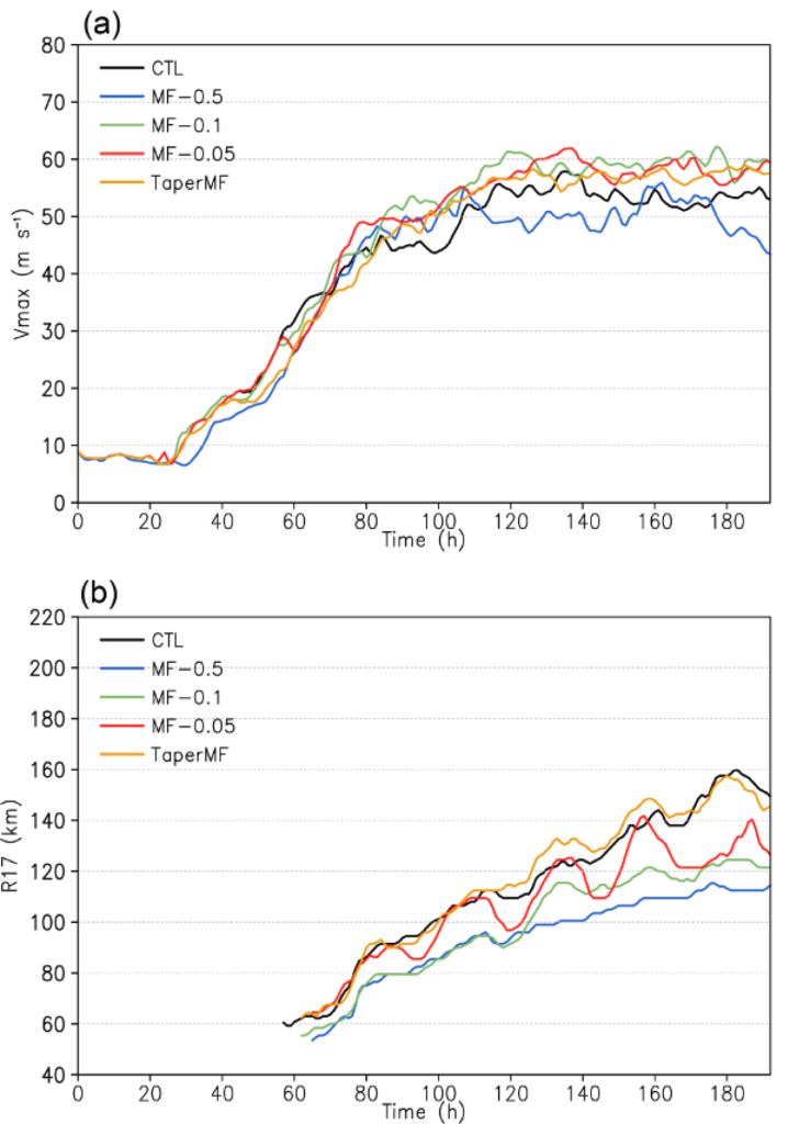
- The new approach of MF tapering can lead to a stronger and more compact inner core due to enhanced boundary layer inflow outside the RMW. An interesting finding is that this approach can affect the entire TC size (i.e., the radius of gale-force wind speed) (Fig. 1).
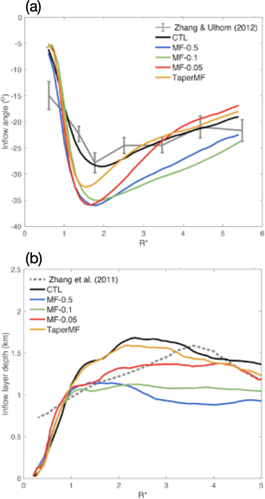
- Comparison with observations lends some support for using this new approach in terms of the depth of the inflow of warm, moist air into the core in the PBL that affects the TC intensity and of changes to TC structure. A full evaluation requires more observations in real TC boundary layers than we currently have (Fig. 2).

For more information, contact aoml.communications@noaa.gov. This work is supported by the National Oceanic and Atmospheric Administration Grants NA23OAR4590380 and NA21OAR4320190. The study can be found at https://doi.org/10.1175/JAS-D-23-0086.1.
