

NOAA’s Hurricane Hunters continue reconnaissance for major Hurricane Teddy, conducting numerous science experiments developed by AOML and its collaborators.
The two P-3 aircraft will take off from St. Croix, U.S. Virgin Islands at 10 AM and 6 PM EDT, respectively, on September 18 as tasked by AOML’s Hurricane Research Division. AOML hurricane scientists will guide and provide onboard and remote support for these missions.
The P-3s will pass through the center of Teddy multiple times and obtain data in all quadrants of the storm, performing objectives outlined in NESDIS Ocean Winds, Rainband Complex Survey, Eye-eyewall mixing and Gravity Wave Module experiment descriptions.
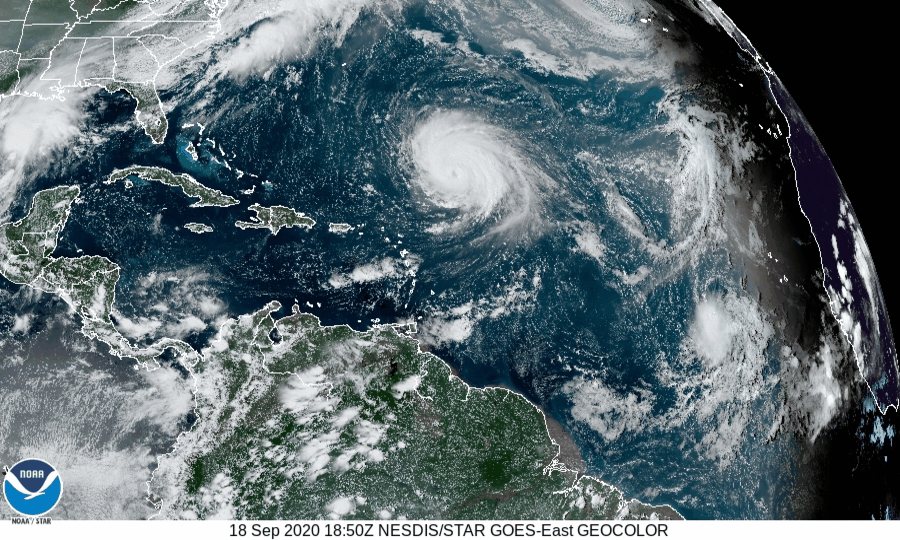
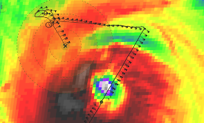
Overnight, Hurricane Teddy maintained a well-defined structure and category-4 surface winds. Hurricane scientists used this opportunity to conduct microphysic spirals as part of their Rainband Complex Survey. These spirals are designed to observe the size and types of water and ice particles both above and below the freezing level in the hurricane. NOAA’s P-3 measured the circulation’s conditions using Tail Doppler Radar and other onboard sensors to learn about processes important to the development of clouds, rainfall, and their cumulative characteristics, like rainbands.
Para esta configuración del proyecto Rainband, el P-3 de la NOAA subió de 8.000 a 20.000 pies en el lado noroeste de la circulación. A esta altitud, la instrumentación a bordo de la aeronave puede recoger datos por encima del nivel de congelación donde existen pocas observaciones. Las mediciones en esta región son cruciales para entender los procesos microfísicos que contribuyen a la evolución de un ciclón tropical.
"Es la primera vez desde que estoy en el AOML que hacemos un patrón como este", dijo el investigador principal del proyecto Rob Rogers, PhD. "Nos dará algunas observaciones muy necesarias por encima del nivel de congelación."
La orientación de las bandas pluviales y el momento del vuelo permitieron el muestreo de una posible banda pluvial "primaria", que se conecta con la pared ocular en un lugar específico en relación con la dirección de la cizalla vertical del viento que el huracán Teddy estaba experimentando.
Stratiform rain in this region consists of homogeneous rainfall and wind characteristics, where similar conditions exist over a large area. The P-3 targeted this location and successfully accomplished goals outlined for the project.

El conjunto de datos obtenidos durante esta misión en el gran huracán Teddy puede dar lugar a importantes avances en la comprensión de los procesos de las nubes que pueden dictar la configuración de la convección y su efecto en la progresión del ciclo de vida de un huracán. Los conocimientos adquiridos en este proyecto servirán de base para los ajustes de los esquemas de parametrización de la microfísica que los modelos meteorológicos numéricos utilizan para aproximarse al efecto de los procesos de pequeña escala en el desarrollo general de los ciclones tropicales.
NOAA’s P-3 Hurricane Hunters will continue reconnaissance into Teddy over the weekend before relocating in Lakeland, FL, for potential missions in the Gulf of America for Tropical Depression 22. The G-IV will begin flying Tropical Depression 22 tomorrow afternoon for NHC-tasked missions.
>> Scientist K. Ryan
>> Edits by: R. Kravetz / L. Bucci
For the latest information about tropical cyclones and other weather systems, please visit the NOAA/NWS/National Hurricane Center.
For information on numerical prediction of tropical cyclones, please visit NOAA/NCEP/Environmental Modeling Center.
To access updates on the Intensity Forecasting EXperiment (IFEX) and other activities via Facebook, Twitter, or RSS feed, check out the NOAA/AOML/HRD page.
To directly access updates on IFEX HFP Operations via our WordPress blog on the web, check the site: https://noaahrd.wordpress.com/category/ifex-hurricane-field-program/
DISCLAIMER: The above discussion is intended to provide a brief summary of recent and future HRD Hurricane Field Program Operations. Any use of this material beyond its original intent is prohibited without permission of the HRD Director, Frank Marks (Frank.Marks@noaa.gov). Media inquiries should be directed to AOML Communications (aoml.communications@noaa.gov), Monica Allen (301-734-1123) or Monica.Allen@noaa.gov.