
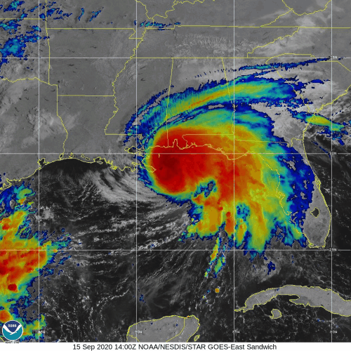
NOAA’s P-3 aircraft wrapped up their sequence of missions into Hurricane Sally prior to the system’s eventual landfall along the central Gulf Coast. Tasked by the National Hurricane Center (NHC), its final flight took off on September 15 at 9:30 EDT from Lakeland, FL.
Hurricane scientists supporting P-3 missions into Hurricane Sally identified the location and strength of the system’s circulation. Onboard instrumentation indicated that the storm’s intensity remains unchanged, with surface wind measuring up to 70 knots.

Rob Rogers, PhD, Lead Project Scientist (LPS) for G-IV missions into Sally, explains that “the dense coverage of dropsondes allows hurricane experts to study how Sally intensified so quickly during a phase of strong pulsing convection and while in the presence of vertical wind shear”.
Sampling atmospheric conditions before and after Hurricane Sally’s rapid intensification revealed how the vortex aligned and the role that the alignment played in the evolution of the system’s development.
AOML’s Hurricane Research Division and its partners tasked NOAA’s G-IV to conduct reconnaissance into Tropical Storm Teddy. The aircraft took off at 12:00 EDT on September 15 from St. Croix, U.S. Virgin Islands, to tackle science objectives defined in AOML’s Synoptic Flow Experiment.
Como parte de una estrategia delineada en el Experimento de Pronóstico de Intensidad(IFEX) del AOML, este experimento se centra en la recolección de mediciones con sondas a gran altitud dentro de la tormenta y su entorno.
It uses an experimental product that identifies regions where numerical models can benefit the most from additional observations during their initialization. Dropsondes released at these locations can facilitate the assessment of this product for the use of targeting in operational tropical cyclone prediction.

La aeronave P-3 planea trasladarse a Santa Cruz para las misiones de seguimiento en Teddy el 16 de septiembre.
>> Scientist K. Ryan
>> Edits by R. Kravetz
For the latest information about tropical cyclones and other weather systems, please visit the NOAA/NWS/National Hurricane Center.
For information on numerical prediction of tropical cyclones, please visit NOAA/NCEP/Environmental Modeling Center.
To access updates on the Intensity Forecasting EXperiment (IFEX) and other activities via Facebook, Twitter, or RSS feed, check out the NOAA/AOML/HRD page.
To directly access updates on IFEX HFP Operations via our WordPress blog on the web, check the site: https://noaahrd.wordpress.com/category/ifex-hurricane-field-program/
DISCLAIMER: The above discussion is intended to provide a brief summary of recent and future HRD Hurricane Field Program Operations. Any use of this material beyond its original intent is prohibited without permission of the HRD Director, Frank Marks (Frank.Marks@noaa.gov). Media inquiries should be directed to AOML Communications (aoml.communications@noaa.gov), Monica Allen (301-734-1123) or Monica.Allen@noaa.gov.