AL14 / MICHAEL MISSION HIGHLIGHTS
-
Four EMC-tasked NOAA P-3 missions were flown into Hurricane
Michael in the Gulf of Mexico. The missions were flown in support of the
NOAA/NCEP/Environmental Modeling Center to provide airborne Tail Doppler radar
and dropsonde observations to initialize the operational Hurricane Weather
Research and Forecasting (HWRF) Model. The four missions were flown every 12
hours, operating out of Lakeland, FL, with takeoffs at 4 AM (0800 UTC) and 4
PM EDT (2000 UTC) between 8 and 10 October. The four missions were: 20181008H1
[4 PM EDT, Monday, October 8], 20181009H1 [4 AM EDT, Tuesday, October 9],
20181009H2 [4 PM EDT, Tuesday, October 9], and 20181010H1 [4 AM EDT, Wednesday,
October 10].
- Three G-IV missions operated in the environment surrounding
Hurricane Michael. The first [20181008N1] and second [20181009N1] missions were
NHC-tasked synoptic surveillance, while the third [20181009N2] was tasked by
AOML/HRD for research. The synoptic surveillance patterns
sampled the steering flow around Michael, as well as an additional
circumnavigation of the storm core at a radius of approximately 100 miles from
the center. The goal of the research mission was to not only observe the
environmental properties (specifically relative humidity and vertical wind
shear) surrounding Michael, but also measure the thermodynamic properties in
the near-storm environment within 100 miles of the center, simultaneously with
the P-3 sampling.
- A total of 107 dropwindsondes were launched over the four P-3
missions into Michael (19 in 20181008H1, 32 in 20181009H1, 30 in
20181009H2, and 26 in 20181010H1). All sondes were launched from an altitude
of 8 kft pressure altitude.
- A total of 102 dropwindsondes were launched over the three G-IV
missions into and around Michael (38 in 20181008N1, 36 in 20181009N1, and
28 in the 20181009N2 research mission). All sondes were launched from an
altitude above 40 kft.
- Led by HRD colleagues at the University of Miami/RSMAS (Nick Shay,
Benjamin Jaimes de la Cruz, and Joshua Wadler), the goal of releasing the
ocean probes (AXBTs, AXCPs, and AXCTDs) was to observe the ocean properties
in the path of the storm, understand the interaction between the ocean and
atmosphere through surface flux measurements within the storm environment,
and observe the change in ocean properties due to the storm passage.
- A total of 68 AXBTs (Airborne EXpendable BathyThermographs) were
launched from the P-3 into Michael (14 in 20181008H1, 16 in 20181009H1,
19 in 20181009H2, and 19 in 20181010H1). A total of 18 AXCPs (Airborne
EXpendable Current Profilers) were released (8 in 20181008H1, 6 in
20181009H1, and 4 in 20181010H1), while a total of 11 AXCTDs
(Airborne EXpendable Conductivity Temperature and Depth) probes were released
(8 in 20181008H1, 2 in 20181009H1, and 1 in 20181010H1).
- The 14 AXBTs released during the 20181008H1 mission served as a
pre-storm survey of the ocean conditions in the forecast track of Michael north
of where the storm was being flown on 8 October. P-3 missions on 11 and 12
October released 40 ocean probes in the wake of Michael to sample the ocean
characteristics following Michael, and to compare to the pre-storm and in-storm
sampling accomplished on the previous P-3 missions.
- Several HRD scientists were involved as crew onboard both the P-3
and G-IV. Rob Rogers, Andrew Hazelton, Kathryn Sellwood, Kelly Ryan, Joe Cione,
Jason Sippel, and Jon Zawislak participated as crew on the P-3, while John
Kaplan flew on the 20181009N2 G-IV research mission. In addition, Josh
Wadler and Benjamin Jaimes de la Cruz (both affiliated with the
University of Miami/RSMAS) participated on the P-3 as the ocean survey data
scientists, while Stephanie Stevenson (CIRA/NHC) flew on the 20181008H1 P-3
mission. Stephanie has been involved in the operational transition of P-3 and
G-IV data into the AWIPS-II environment at NHC.
- Paul Reasor and John Gamache provided ground radar science support
for the P-3 and G-IV missions. The ground support assist in the transmission of
the Tail Doppler Radar (TDR) analyses from the aircraft to EMC and NHC.
- Although the primary mission of the P-3 and G-IV flights
were for operations (NHC and the NOAA/NCEP/Environmental Modeling
Center), scientifically the observations obtained over the 3 days are
considered one of the most comprehensive datasets in a rapidly intensifying
storm in the historical record of the Hurricane Field Program -
Intensity Forecasting Experiment (IFEX). The data collection
specifically met objectives of the Early and Mature Stage Experiments, as well
as Ocean Survey Experiment, of IFEX.
- During the third P-3 mission (20181009H2), the Coyote small Unmanned
Aerial System (sUAS) was deployed in the eyewall of Michael following the
completion of the EMC-designed rotated Figure-4 pattern. About
20 minutes of data was retrieved from the Coyote prior to the P-3 losing
communication with it (it’s likely that the Coyote was still
flying, but rather the P-3 was outside the range of communication with the
platform). We collected from the Coyote, data in approximately 1/3 of the
full of the eyewall (the Coyote likely actually flew more of it, and had we
remained in contact would have collected a large portion of the eyewall),
measuring basic state variables (wind, temperature, and humidity) as it was
directed from 2000 ft to lower altitudes. It is believed that winds measured
around 600 m, 159 kt, from the Coyote were the highest ever observed in a
hurricane by a sUAS.
- We were honored, with the blessing of his family, to release the
ashes of our friend, colleague, and mentor, Michael Black into the eye of his
namesake storm on the 20181009H2 mission.
- While flying Hurricane Michael, the storm steadily (and at times,
rapidly) intensified from a minimal hurricane (65 kt) on 8 October, to a strong
Category 4 storm (135 kt) on 10 October, just prior to landfall. Within the
last 24 hours before landfall, Michael intensified from 95 kt to 135 kt. The
P-3 and G-IV data, in conjunction with data from the 53rd Air Force Weather
Reconnaissance squadron C-130s, will provide a critical dataset for evaluating
rapid intensification processes and understanding the data impact on the track
and intensity forecasts of Michael.
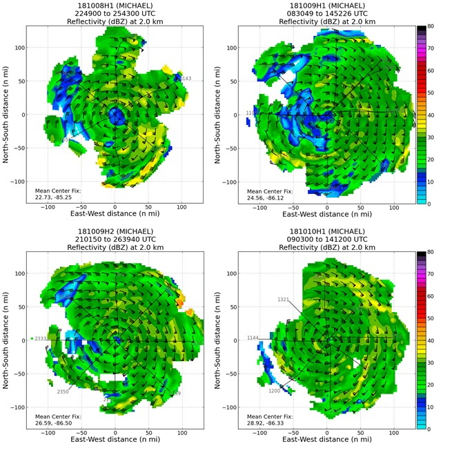
Sequence of P-3 TDR analyses showing composite reflectivity at 2 km, for:
20181008H1, 20181009H1, 20181009H2, and 20181010H1
|
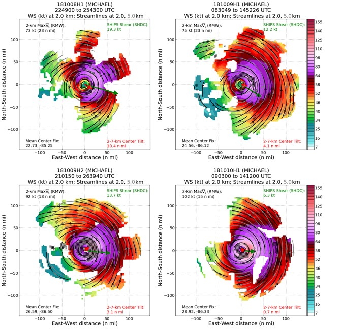
Sequence of P-3 TDR analyses showing wind speed at 2 km (shading), as
well as streamlines at 2.0 (black) and 5.0 km (grey) for: 20181008H1,
20181009H1, 20181009H2, and 20181010H1
|
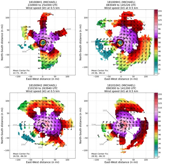
Sequence of P-3 TDR analyses showing wind speed at 0.5 km for:
20181008H1, 20181009H1, 20181009H2, and 20181010H1
|
Jon Sawislak
Field Program Director
Return to Michael Main Page.
|
|
