EP14 / LANE MISSION HIGHLIGHTS
- First NOAA P-3 mission (since they arrived at AOC in the early
1970's) to fly into a hurricane in the Central Pacific
- First time the NOAA P-3 based out of Hawaii for hurricane operations
(note that the NOAA G-IV has done this numerous times, most recently in
Hector this season, and also flew synoptic surveillance missions around Lane,
tasked by the Central Pacific Hurricane Center; the 53rd has also flown regular
reconnaissance out of Hawaii)
- Real-time viewings of data from the P-3 (including Tail Doppler
radar data) in AWIPS II at the Central Pacific Hurricane Center.
Their discussions noted their use of the P-3 data:
CPHC Discussion, 1100 PM HST, 19 August: "Aircraft from the NOAA Aircraft
Operation Center and the U.S. Air Force Reserves 53rd Weather Reconnaissance
Squadron have been sampling Hurricane Lane this evening. The data provided
by these missions have been invaluable."

CPHC Discussion, 0500 AM HST, 20 August: "Radar reflectivity data sent from
the NOAA aircraft between 0510z and 0722z showed that Lane's eyewall was open
in the southeastern quadrant."

CPHC Discussion, 1100 AM HST, 20 August: "Air Force Reserve Hurricane Hunters
found a maximum flight level wind of 121 kt, and the NOAA Hurricane Hunters
found maximum SFMR wind of 113 kt earlier on the northwest quadrant."

CPHC Discussion, 1100 PM HST, 20 August: "Aircraft from NOAA and the 53rd
Weather Reconnaissance Squadron have been flying through lane at 8 to 10
thousand feet respectively this evening, and are confirming that Lane is
a powerful hurricane that has intensified since their last visit this
morning."

CPHC Discussion, 0645 PM HST, 21 August: "Data from the NOAA P-3 aircraft
indicate that Lane has strengthened to a category 5 hurricane."
- AOC was able to accommodate many guest fliers on the P-3 from the
NWS/Weather Forecast Office/Honolulu, Central Pacific Hurricane Center (CPHC),
and the Joint Typhoon Warning Center (JTWC)
- First all female HRD science crew on a NOAA P-3 Hurricane Hunter
flight. This also just so happened to occur when Lane reached peak
intensity of 140 kt (a Category 5 hurricane, which is rare in the Central
Pacific).
- 4 EMC-operationally tasked P-3 missions were flown into Lane
(EP14) in the Central Pacific, while it was a major hurricane
12-hour operations with takeoff times at 4 AM HST (1400 UTC, 10 AM EDT) and 4
PM HST (0200 UTC, 10 PM EDT): 20180820H1, 20180820H2, 20180821H1, 20180822H1.
- The goal of the missions was to collect data (Tail Doppler radar,
flight level, and dropsonde) for assimilation into the 0600 and 1800 UTC
forecast cycles of the Hurricane Weather Research and Forecasting (HWRF)
operational model. It was also an opportunity to collect Doppler Wind
Lidar (DWL) and Wide-swath Radar Altimeter (WSRA) data before they are to
be swapped off the aircraft.
- There were also 4 CPHC-tasked Synoptic Surveillance NOAA G-IV
missions into Hurricane Lane 20180819N1, 20180820N1, 20180821N1,
20180822N1. These missions targeted synoptic flow features around Lane
that could affect the eventual steering of the storm. Considering the
shift and reduction in track spread (that ultimately led to the storm
being steered directly towards the Hawaiian Islands) as the aircraft
missions were flown, observations were likely impactful (though impact
studies will be forthcoming).
- TDR analyses were successfully produced on each P-3 mission, and
superobs sent to EMC in near real-time for assimilation into HWRF
In addition, these radar analyses were also produced and transmitted from the
G-IV TDR during their synoptic surveillance missions. We were first
successful in producing TDR analyses from the G-IV TDR during the Hector
missions.
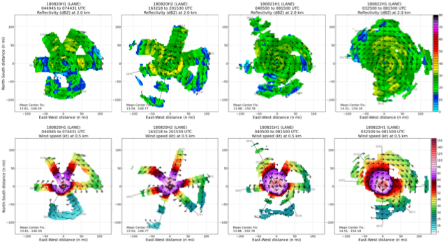
Sequence of P-3 TDR analyses showing composite reflectivity (top row),
and wind speed at 0.5 km (bottom row), for P-3 missions: 20180820H1,
20180820H2, 20180821H1, 20180822H1, from left to right
|
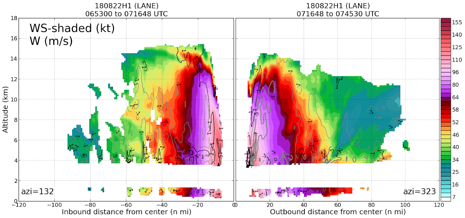
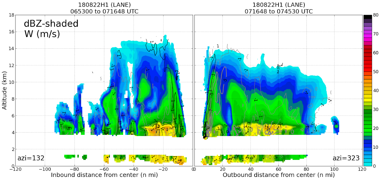
Reflectivity (top) and wind speed (bottom) vertical cross sections on
the 3rd pass of Lane during 20180822H1, during its peak intensity as a
Category 5
| |
- There were 5 missions into Lane by the 53rd Air Force Reserve
Hurricane Hunter C-130s
- There were 77 P-3, 119 G-IV, and 49 C-130 (245 total) dropsondes
in Hurricane Lane: P-3 (20180820H1 [16]; 20180820H2 [12]; 20180821H1 [23];
20180822H1 [26]), G-IV (20180819N1 [30], 20180820N1 [29], 20180821N1 [28],
20180822N1 [32]), C-130 (20180820U1 [8], 20180820U2 [8], 20180821U1 [5],
20180821U2 [13], 20180822U1 [15])
- Unfortunately, the originally scheduled 4 AM mission on Tuesday 21
August, 20180821H2, had to be scrubbed to do an inspection of the
P-3 after it experienced 3.1 G acceleration during an eyewall penetration
during the previous mission (20180821H1).
- In addition, vibrations likely associated with the DWL installation
were detected during the P-3 mission 20180821H1 on their transit
back to Honolulu. These vibrations appeared during the following P-3
mission, 20180822H1, and required the mission to be aborted prior to their
fourth and final pass of the storm.
- P-3 missions were not able to continue into Wednesday as the crew
required the aircraft to be evacuated back to the mainland in advance
of the expected arrival of tropical storm conditions on Oahu, possibly
as early as Thursday morning. The C-130s also evacuated.
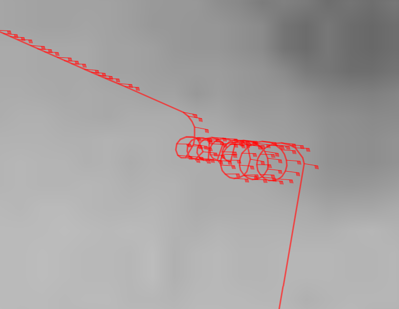
- SFMR High Incidence Angle Module was flown on 3 of the 4 flights:
(20180820H2, 20180821H1, 20180822H2) (Objective #1 of the "SFMR Experiment").
This involves flying circles at 15, 30, and 45 degree roll angles, thus
measuring the response of the SFMR at high-incidence angles. These are the
first modules flown with a 2nd down-looking SFMR on the P-3 (thus having
both horizontal and vertical polarizations).
|
|
|
The execution of the SFMR "Circles" modules on 20180820H2 (left) and
20180822H1 (right)
|
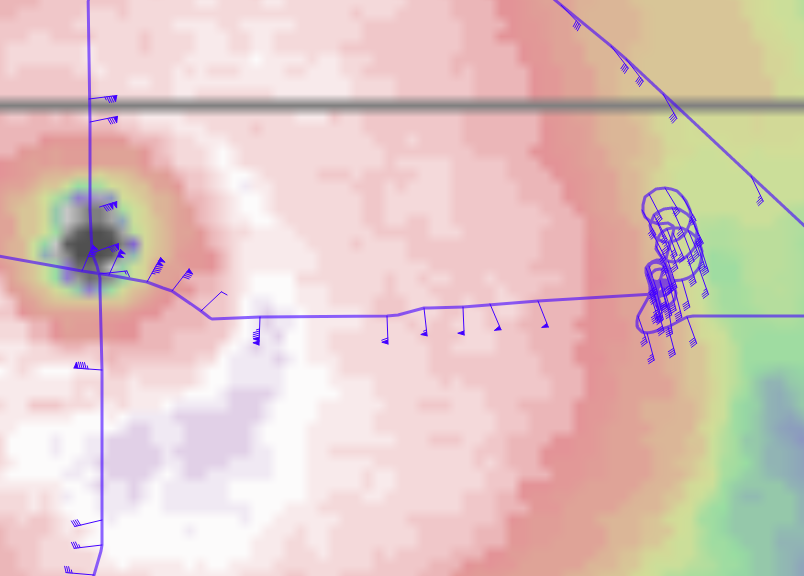
- Gravity Wave Module (within Objective #1 of the "Mature Stage
Experiment") flown during 20180821H1. This involved repeated
sampling along the same azimuth (NW) during an eyewall penetration, extending
one leg out to 160 nmi away from the storm.
The Gravity Wave module on 20180821H1, along the 315 degree azimuth in
the northwest quadrant
|
|
|