EP96 / GENESIS MISSION HIGHLIGHTS
-
Three research tasked (by HRD) NOAA P-3 missions were flown into
Invest 96E in the East Pacific, in support of the Genesis Stage
Experiment, part of the Hurricane Field Program - Intensity Forecast Experiment
(IFEX). These missions were flown once daily out of Liberia, Costa Rica
between 26 and 28 September, with takeoffs on the 26th. at 1600 UTC (10 AM
local / 12 PM EDT), and at 1300 UTC (7 AM local / 9 AM EDT ) on the 27th
and 28th. The P-3 ferried to Costa Rica on 25 September. While we were
flying the first mission on 26 September, EP96 was only being given a "low"
chance of formation in the NHC 2 and 5-day Tropical Weather Outlook (TWO).
During the second mission, NHC increased the probability of genesis to "medium"
and initialized the disturbance as "Invest" EP96. By the third mission, NHC
increased the probability of formation to "high" as it was apparent that EP96
was likely to develop into a tropical cyclone within 48 hours. P-3 data
contributed to NHC outlooks for EP96.
- The sequence of flights will allow us to address Objectives #1
(Precipitation Mode) and #2 (Pouch) of the Genesis Stage Experiment.
While the final mission on 29 September, which would have captured the
structure of the developed storm (Tropical Storm Sergio), was cancelled due to
a mechanical issue on the P-3, the previous three missions certainly captured
EP96's structural evolution during its pre-genesis stage. Very few
pre-genesis cases exist within the long history of the Hurricane Field
Program, and the three missions flown could prove to be one of the best
genesis datasets collected by the P-3. It's made even more unique by the fact
that very little airborne data, in general, exists within East Pacific events.
- Participating HRD P-3 Science Crew:
Jon Zawislak (Lead Project Scientist, Radar Scientist, HFP Field Program
Director), Rob Rogers (Lead Project Scientist, Radar Scientist), and Jun
Zhang (Dropsonde Scientist) were on the P-3. Paul Reasor provided ground
radar science support for the P-3 missions. The ground support assist in
the transmission of the Tail Doppler Radar analyses from the aircraft to
EMC and NHC. NESDIS (IWRAP instrument) was represented by Paul Chang,
Zorana Jelenak, and Joe Sapp.
- A total of 52 dropwindsondes were launched over the three P-3 missions
into EP96 (16 in 20180926H1, 18 in 20180927H1, 18 in 20180928H1). Sondes
were released from an altitude of 14000 ft in 20180926H1, and at 12000 ft in
20180927H1 and 20180928H1. Altitudes were adjusted to accommodate data
collection for the Imaging Wind and Rain Airborne Profiler (IWRAP) instrument.
Some of the dropsondes released include IR sondes, which can also measure SST
in clear conditions. 13 IR sondes were released of the 52 total during the
missions (5 in 20180926H1, 4 in 20180927H1, 4 in 20180928H1).
- A total of 7 Airborne EXpendable BathyThermograph (AXBTs) were launched
from the P-3 into EP96 over the first 2 missions. The goal is to observe
the surface fluxes, as well as validate satellite measurements of the SST.
Unfortunately, the majority of these AXBTs did not report data. SST from the
IR sondes could be used in place of these failed AXBT SST measurements.
- The goal of the first mission, 20180926H1, was to survey the winds
associated with the Papagayo Gap flow, as well as the disturbance to the west,
with a box pattern. The Papagayo Gap flow is a region of enhanced lower
tropospheric winds over the East Pacific (close to the coast) caused by
funneling of flow through the Papagayo Gap of Nicaragua to the north of Costa
Rica. They are thought to contribute to the spinup of a circulation. The
westernmost northwest to southeast leg transected a surface trough associated
with the developing disturbance.
- The second (20180927H1) and third (20180928H1) missions were
square-spiral patterns, which were planned to be centered on the apparent broad
low-level circulation of the disturbance. The square-spiral design permits a
gridded survey of dropsondes across the disturbance region, which will allow us
to better identify the location of circulation centers up to flight level (12
kft). Wind and reflectivity analyses were also produced from the Tail
Doppler Radar (TDR) (figures below), similar to what has been done for
developed storms.
- During both the second and third missions, we were able to
identify a broad surface circulation within the grid from both dropsondes and
the TDR analyses. In the third mission we were also able to identify a coherent
mid-tropospheric mesoscale convective vortex (MCV), which is commonly found in
the stratiform rain region of a mesoscale convective system (MCS).
In this case, the MCS and associated MCV observed was on the eastern edge of
the broad surface circulation, and very likely played a role in the eventual
development of Sergio.
- Although the P-3 missions were research tasked, TDR data was
successfully transmitted to EMC for assimilation into HWRF for the 20180928H1
mission, when the Invest was already initiated (as well as the usual flight
level and dropsonde observations) (no data was assimilated in previous missions
as an Invest had not yet been initiated by NHC). TDR data from each flight
was also provided for AWIPS-II, where the NHC Hurricane Specialists were able
to view the data in near real time (within about 1.5 hr after data collection).
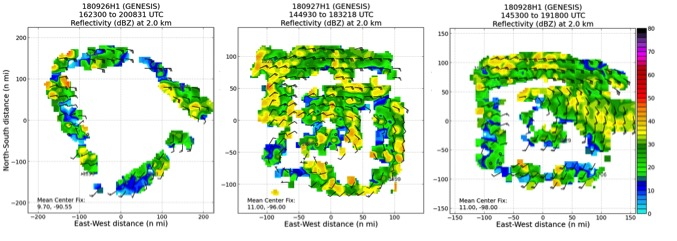
Sequence of P-3 TDR analyses showing composite reflectivity at 2 km for:
20180926H1, 20180927H1, and 20180928H1, from left to right
|
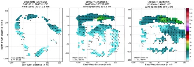
Sequence of P-3 TDR analyses showing wind speed at 0.5 km for: 20180926H1,
20180927H1, and 20180928H1, from left to right
|
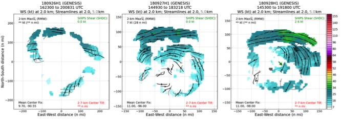
Sequence of P-3 TDR analyses showing wind speed at 2 km (shading), as well
as streamlines at 2.0 (black) and 5.0 km (grey) for: 20180926H1, 20180927H1,
and 20180928H1, from left to right
|
Jon Zawislak
Field Program Director
Return to Genesis Main Page.
|
|
