Skip to Content

Category Archives: Hurricane Research

NOAA Hurricane Hunter Radar Paints Picture of Hurricane Winds

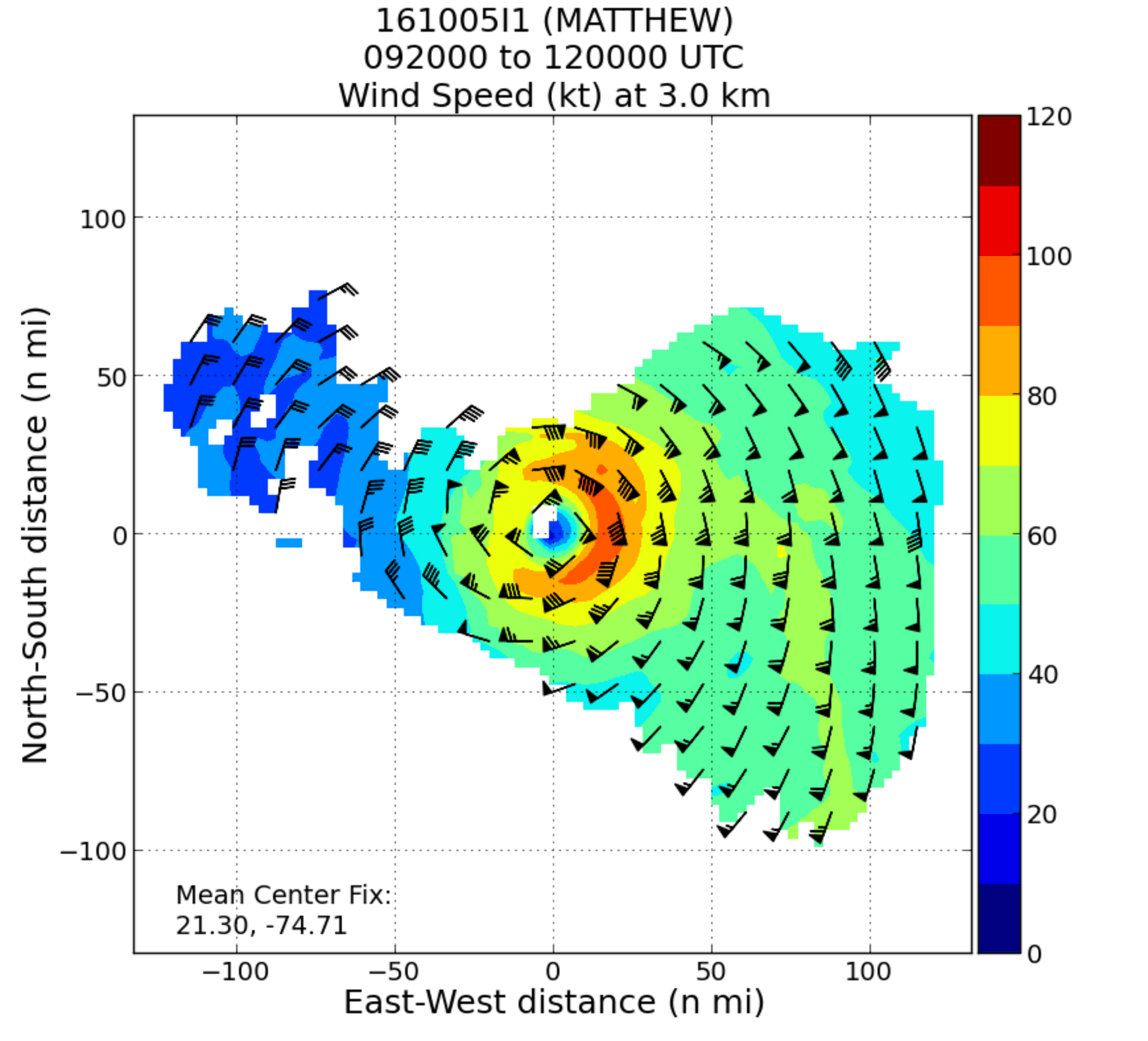
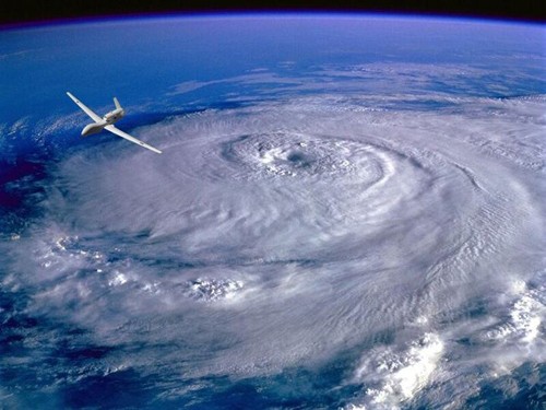
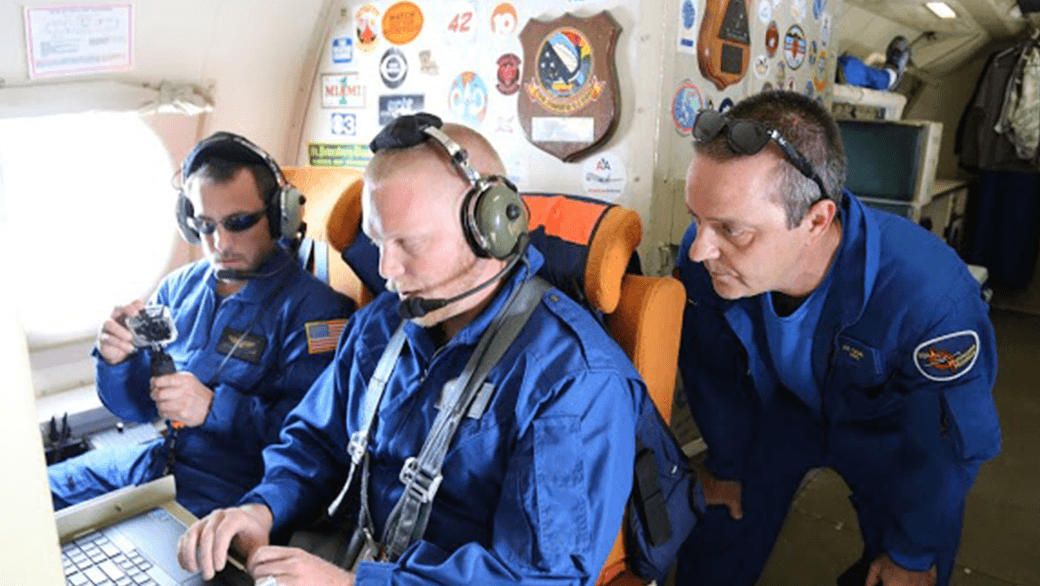
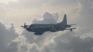
NOAA’s hurricane hunter aircraft carry a unique radar that measures wind in hurricanes where there is rain. Located in the tail of the aircraft and known as the Tail Doppler Radar, this instrument produces images that can provide detailed pictures scientists use to study storm structure and changes. Scientists can also piece together wind speed information gathered over the course of a flight to paint a complete picture of the wind speed in the regions of the storm where the aircraft flies.

0 Continue Reading →

Through the Eyewall – My Experience with the NOAA Hurricane Hunters

There aren’t many people who can say they have flown directly into a hurricane, but on October 5, 2016, I had a very unique opportunity to fly into Hurricane Matthew with NOAA’s Hurricane Hunters. Matthew was quickly moving across the Atlantic Ocean, and each new forecast moved it closer to the East Coast of Florida. With the high potential for hurricane watches and warnings, NOAA started preparations for routine flight operations.

0 Continue Reading →

September 22: Reddit Science AMA with NOAA’s Hurricane Hunters

With hurricane season in full swing, NOAA will host a Reddit Ask Me Anything (AMA) about the Science of Hurricane Hunting to Improve Forecasts on September 22, 2016 at 1:00 p.m. Hurricane scientist Frank Marks, Sc.D., Director of the Hurricane Research Division at AOML, and P-3 hurricane hunter pilot Commander Justin Kibbey of the NOAA Corps will answer questions. The first half of hurricane season has produced a significant number of storms in the Atlantic and Gulf of Mexico. This AMA is a great opportunity to answer questions about how and why we study these storms.

0 Continue Reading →

Capturing the Genesis of a Hurricane

NOAA Hurricane Hunters are flying back-to-back missions to study the newly developed Tropical Storm Hermine in the Gulf of Mexico, capturing its evolution from a cluster of thunderstorms into a tropical storm. Getting data during such transitions can help improve hurricane models which currently don’t predict transitions well. Our understanding of the physical processes of early storm development remains limited, largely because there are few observations. 

0 Continue Reading →

Technology and Modeling Innovations Usher in the 2016 Hurricane Season

Scientists at NOAA’s Atlantic Oceanographic and Meteorological Laboratory (AOML) are at the vanguard of hurricane research. Each hurricane season we fly into storms, pore over observations and models, and consider new technological developments to enhance NOAA’s observing capacity and improve track and intensity forecasts. The 2016 hurricane season will provide an opportunity for our scientists to test some of the most advanced and innovative technologies and refined forecasting tools to help better predict a storm’s future activity.

0 Continue Reading →

From the Eye of the Hurricane to High-Resolution Models – How NOAA Improves Hurricane Forecasts

As a hurricane approaches landfall, citizens are hoping that they are adequately prepared for the potential damage from strong winds and rising oceans. NOAA’s job is to forecast the storm location and strength, or intensity, to help communities make the best informed decisions. For many scientists, predicting intensity is a challenge at the forefront of hurricane research, and in recent years advancements in observations and modeling have improved NOAA’s forecasts of intensity by 20%. We are now at the point where scientists can observe and predict with very fine detail what is happening in the inner core of the storm.

0 Continue Reading →

NOAA Advances Hurricane Research Technology with Improved Unmanned Aerial Vehicles

A team from NOAA and Raytheon successfully demonstrated recent advancements of the Coyote Unmanned Aircraft System (UAS) while completing a mid-flight launch from the NOAA P-3 Hurricane Hunter aircraft on January 7th. The successful flight verified new technology designed to improve Coyote’s ability to collect vital weather data to improve hurricane forecasts.

0 Continue Reading →

Behind the 2015 Atlantic Hurricane Season: Wind Shear & Tropical Cyclones

Wind Shear
No Wind Shear

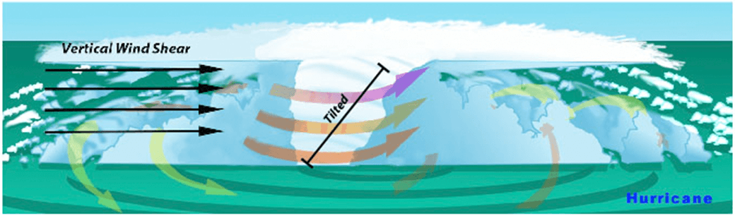
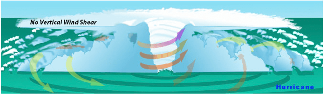
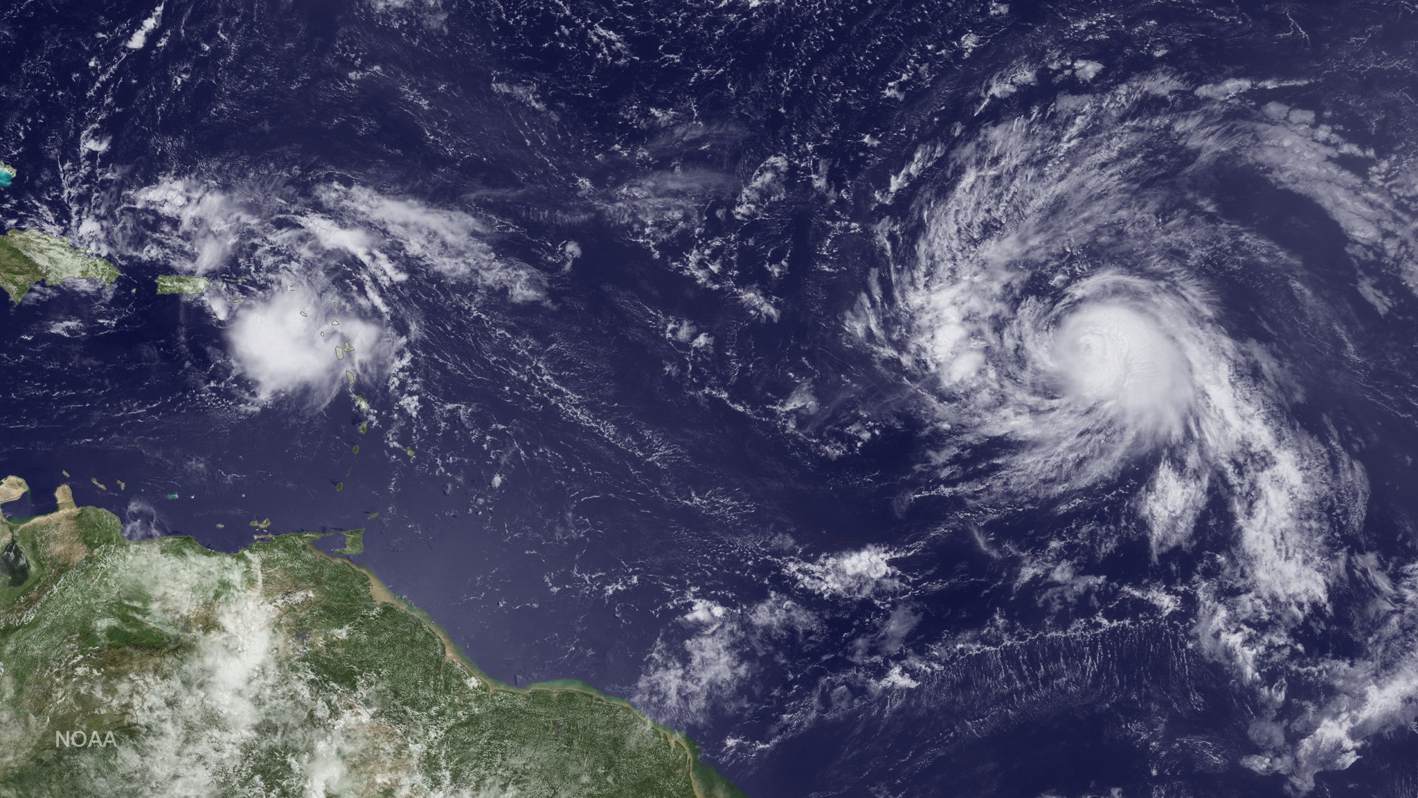
In the presence of vertical wind shear, a storm’s core structure will be tilted in relationship to the wind shear. This tilting will disrupt the flow of heat and moisture which inhibits the storm from developing and becoming stronger.

With the 2015 Atlantic hurricane season underway, researchers are pointing to the strong presence of El Niño as the major driver suppressing the development of tropical cyclones in the Atlantic basin. But what specific conditions are associated with El Niño that lead to a less than ideal environment for tropical cyclone development? Through research and observation, hurricane researchers know strong environmental wind shear is a major factor affecting potential hurricane development and growth. This hurricane season, AOML researchers are delving further into the relationship between wind shear and tropical cyclones.

What is wind shear?

Wind shear is the variation of the wind’s speed or direction over a short distance within the atmosphere. For tropical cyclones, wind shear is important primarily in the vertical direction, as these storms occupy a large vertical slice of the atmosphere from sea level to the top of the troposphere, which extends up to about 40,000 feet altitude in the tropics in summer.

How does wind shear affect tropical cyclone development?

Tropical weather systems are vulnerable to changes in the broader atmosphere surrounding them; often influenced by large features such as areas of high and low pressure, and fronts. If there’s too much wind, these weather systems have trouble organizing and developing into a tropical cyclone. As a tropical system forms, heavy thunderstorms build near the center. Given the right environment, these systems can eventually begin turning counter-clockwise (or cyclonically) in the northern hemisphere. With little to no wind shear, the turning within the tropical system is uniform and the storm becomes vertically aligned, helping to keep it intact and, likely, strengthening.

The most favorable condition for tropical cyclone development is the absence of wind shear. When wind shear is present, however, a storm’s core structure becomes vertically tilted in relationship to the wind shear, disrupting the flow of heat and moisture. Tropical cyclones are heat engines powered by the massive heat release associated with water vapor condensing into liquid water. Vertically-tilted systems are less efficient at drawing in warm and moist air from the surrounding ocean and will be less likely to develop and strengthen.

How does El Niño affect the presence or absence of wind shear?

El Niño is a climate phenomenon driven by above average ocean temperatures in the central and eastern tropical Pacific. While that warmth helps boost Pacific storm activity, the extra heat transferred to the atmosphere leads to a domino effect, altering climate around the globe.

Specifically, the instability over the warm equatorial Pacific during El Niño creates changes in the jet stream over the Northern Hemisphere, resulting in decreased wind shear in the Pacific and increased wind shear across much of the Caribbean and Atlantic. El Niño also increases the atmospheric stability, or resistance of the atmosphere to vertical motion, in the Atlantic basin, which suppresses hurricane activity.

Can a storm persist despite the existence of wind shear?

AOML researchers are focusing on particular characteristics of developed tropical cyclones that enable them to persist despite increased levels of wind shear. The theoretical work focuses mainly on how a tropical cyclone’s wind structure is disrupted by wind shear.

Using a simple mathematical model, researchers can estimate the degree to which the center of the storm becomes vertically tilted based on the cloudiness within the eyewall, as well as the structure of the wind outside the eyewall. By modeling the development of storm tilt, a better understanding of a tropical cyclone’s behavior is gained in the presence and absence of wind shear.

Results suggest that tropical cyclones are more likely to resist disruption by vertical wind shear when clouds cover a large portion of the eyewall and when winds decrease less rapidly from the eye. These model simulations show promise in understanding the fundamental physical processes driving intensity and structural changes of tropical cyclones due to environmental factors.

Model results suggest certain features such as cloudiness within the eyewall as well as the structure of the wind outside the eyewall may determine a storm’s level of resistance to wind shear.

A Doppler wind lidar instrument added to NOAA’s hurricane hunter aircraft this season will assist AOML researchers in collecting observational data to better understand the wind environment around tropical cyclones. The lidar instrument is used to collect, process, and transmit atmospheric data from within a hurricane, enabling NOAA to sample the winds inside the eyewall of storms. By leveraging observational expertise and new data combined with modeling, AOML researchers hope to learn more about the wind environment and the interaction between wind shear and tropical cyclones, allowing them to better predict a hurricane’s future activity and intensity.

Originally Published by Edward Pritchard, AOML

0 Continue Reading →

NOAA Researchers Will Use 2015 Season to Improve Hurricane Track and Intensity Forecasts

This hurricane season, NOAA’s Office of Oceanic and Atmospheric Research will work with NOAA’s National Weather Service to upgrade weather forecast models and conduct research with unmanned air and water craft to improve forecasts of hurricane track and intensity.

A highlight this season is the upgrade of the operational Hurricane Weather Research and Forecast system (HWRF), an advanced hurricane prediction model. This year’s version now has increased the resolution from 3 to 2 kilometers, and will use tail Doppler radar data collected from the NOAA P-3 and G-IV hurricane hunter aircraft to improve the storm representation within the model.

With each upgrade to a higher resolution the model helps improve predictions of hurricane intensity because we’re able to more closely model features such as clouds that can significantly affect storm intensity,” said Frank Marks, Sc.D., director of NOAA’s Hurricane Research Division. “Our goal is to give communities the forecasts they need to be ready, responsive and resilient to severe weather.

Not only does the operational HWRF have better resolution but NOAA is also running HWRF globally in support of the Joint Typhoon Warning Center, the center responsible for issuing tropical cyclone warnings for the U.S. Department of Defense for the North West Pacific Ocean, South Pacific Ocean and Indian Ocean. There is also a new data assimilation system that takes advantage of the HWRF ensemble to do inner core assimilation of the aircraft data.

NOAA’s Hurricane Research Division and Unmanned Aircraft Program will be working with NOAA’s Environmental Monitoring Center to transition the G-IV Tail Doppler Radar and NOAA dropsonde data collected by the NASA Global Hawk into operational use. We will be demonstrating the potential of the NASA Global Hawk unmanned aircraft, the smaller unmanned aircraft called Coyote, ocean gliders, and Doppler wind Lidar as new observing technologies that could be used to improve forecasts of intensity and track.

NOAA is also adding a Doppler wind Lidar on the P-3 aircraft which is used to collect, process and transmit atmospheric data from within a hurricane. The Lidar will complement the P-3 tail Doppler radar, allowing NOAA to sample the winds inside the hurricane, even within the eye of the storm, which may be driving rapid changes in hurricane intensity.

Building upon earlier collaborative research with NASA, NOAA will direct 10 flights of the Global Hawk in late August through early September to gather data on hurricanes to improve forecasts of intensity and track. The Global Hawk will carry instruments to measure temperature, moisture, wind speed and direction to profile hurricanes from 60,000 feet down to the surface of the ocean. The new mission for the Global Hawk is called Sensing Hazards with Operational Unmanned Technology and was funded in part by the Disaster Relief Appropriations Act of 2013.

NASA's Global Hawk aircraft will carry multiple instruments to profile hurricanes during the 2015 field season. (Image Credit:NOAA)

NASA’s Global Hawk flew two 24 hour missions into Tropical Storm Erika to collect and transmit real-time data on the storm. Image Credit: NOAA

Flying the Global Hawk with weather observing sensors above a storm is like putting the storm under a microscope. We can gather high resolution data to see more clearly inside the storm and better capture changes in wind speed and intensity,” said Robbie Hood, director of NOAA’s Unmanned Aircraft System Program. “We are also testing how unmanned aircraft can be a reliable observation tool to augment weather observations from satellites, and in the event of an unplanned gap in satellite coverage, to provide severe weather forecast information.

Not only can the Global Hawk fly at altitudes nearly twice as high as manned aircraft, but it can also fly for 24 hours, much longer than manned aircraft, allowing it to gather data on the evolution of a hurricane over a whole day. Data collected will be used by the National Weather Service operational hurricane forecast system (HWRF) and will be evaluated to determine how they improve forecast guidance on hurricane intensity and track.

NOAA successfully deployed an unmanned aircraft, the Coyote, from a hurricane hunter into the eye of Hurricane Edouard last season, and will expand the use of this small unmanned aircraft this hurricane season. Planned flights timed to hurricanes will measure the regions of strongest winds at low altitudes in hurricanes and send that data in real-time to forecasters at NOAA’s National Hurricane Center.


Unmanned aircraft such as the Coyote will be used to measure the most violent parts of a storm. (Image Credit:NOAA)

Unmanned aircraft such as the Coyote will be used to measure the most violent parts of a storm. (Image Credit:NOAA)

Northern Gulf Institute scientists working with NOAA’s National Weather Service Lower Mississippi River Forecast Center will fly a small unmanned aircraft to study the Pearl River, looking at water levels, vegetation and impacts from storms. The research by the NOAA cooperative institute at Mississippi State University will be used to improve flooding forecasts and damage assessments after flooding in areas that are difficult to reach by manned aircraft, but often severely affected by hurricanes.

NOAA is also planning to deploy two underwater gliders north and south of Puerto Rico to collect data in the upper ocean before, during, and after a storm passes. These measurements will provide a better understanding of the ocean response to a hurricane’s passage, which in turn improves ocean models used in hurricane forecasts.

We must continue to push the boundaries of science to increase lead times for severe tropical storms, floods and other severe weather,” said Marks. “This season’s research is designed to find earlier clues to when a storm rapidly intensifies in order to help build a more weather ready nation.

Originally Published by Shannon Jones, AOML

0 Continue Reading →

Hurricane Danny & Tropical Storm Erika Provide Wealth of Research Opportunities for the 2015 Hurricane Field Program

AOML’s hurricane researchers conducted a number of field activities in August that provided data and critical insights into two Atlantic tropical cyclones, Danny and Erika. The two storms enabled researchers to test new instruments in support of the 2015 Hurricane Field Program and conduct research that will benefit future forecasts. Among the highlights were more than 15 successful manned and unmanned aircraft missions into Danny and Erika to collect and provide real-time data to the National Hurricane Center (NHC), as well as evaluate forecast models.

A geo-referenced radar image taken during Hurricane Danny with the P-3’s lower-fuselage radar on Friday, August 21, 2015. Image credit: NOAA

NOAA flew five P-3 aircraft missions and two G-IV jet missions into Hurricane Danny, the first major hurricane of the 2015 season. For Tropical Storm Erika, NOAA flew five P-3 missions and three G-IV missions as the storm impacted the Caribbean. The P-3 missions into Danny marked the first real-time transmission of geo-referenced imagery from the P-3’s lower-fuselage radar to NHC forecasters. This imagery provided valuable information about the structure of Danny as the storm churned in the Atlantic far from land.

The P-3 flights also measured the wind structure of Danny and Erika and the wind shear environment surrounding them. Using the Tail Doppler Radar aboard the P-3, researchers documented high levels of wind shear across the Caribbean, the product of a strong El Nino and a major factor contributing to the dissipation of both storms.

During missions into Danny and Erika, scientists gathered observations for the first time with a Doppler wind lidar instrument mounted on the side of the P-3 fuselage that measures wind velocity in regions without rain. The lidar data will be processed and evaluated for possible inclusion in the HWRF research model to improve wind speed estimates in model guidance.

NOAA’s P-3 aircraft flew multiple missions into Hurricane Danny & Tropical Storm Erika. Image credit: NOAA

NASA’s Global Hawk unmanned aircraft completed the first two flights of its 2015 NOAA campaign when it flew above Tropical Storm Erika on August 26th and 29th. The Global Hawk used onboard instruments to profile the inner workings of Erika and released dropsondes to collect temperature, moisture, wind speed, and wind direction data. The real-time data were transmitted for the first time and incorporated into operational forecast models.

Other instruments aboard the Global Hawk, such as the microwave sounder from NASA’s Jet Propulsion Laboratory, gathered vertical profiles of temperature and humidity and was able to provide a unique view of Erika’s interaction with the Saharan Air Layer, a mass of dry air that inhibited Erika’s growth.

The Global Hawk, managed by NASA’s Armstrong Flight Research Center in California, provided a unique vantage point of Erika at 60,000 feet altitude, flying about 15,000 feet higher than NOAA’s G-IV jet. Both of its flights were 24 hours in length, nearly three times as long as that of the manned aircraft. The Global Hawk is part of NOAA’s Sensing Hazards with Operational Unmanned Technology (SHOUT) project, which seeks to improve hurricane forecasts of track and intensity using data collected by the unmanned aircraft from high in the stratosphere down to the ocean’s surface.

Below the ocean’s surface, another type of unmanned vehicle was in place, collecting data on Erika’s interaction with the upper level of the ocean as the storm passed through the Caribbean. AOML’s two underwater gliders traversed the waters off Puerto Rico, gathering temperature measurements that are critical to understanding the ocean’s role in how storms form, evolve, and change in intensity. These data should also provide researchers with a better understanding of the ocean’s response to the passage of storms which, in turn, will improve ocean models used in hurricane forecasts.


Data collected by NOAA’s hurricane hunter aircraft and the Global Hawk were uploaded in real-time to the Global Telecommunications System for inclusion in environmental models, better enabling researchers to predict the future activity and intensity of Danny and Erika.

0 Continue Reading →