AOML’s hurricane researchers conducted a number of field activities in August that provided data and critical insights into two Atlantic tropical cyclones, Danny and Erika. The two storms enabled researchers to test new instruments in support of the 2015 Hurricane Field Program and conduct research that will benefit future forecasts. Among the highlights were more than 15 successful manned and unmanned aircraft missions into Danny and Erika to collect and provide real-time data to the National Hurricane Center (NHC), as well as evaluate forecast models.
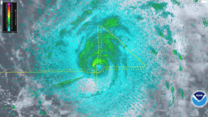
A geo-referenced radar image taken during Hurricane Danny with the P-3’s lower-fuselage radar on Friday, August 21, 2015. Image credit: NOAA
NOAA flew five P-3 aircraft missions and two G-IV jet missions into Hurricane Danny, the first major hurricane of the 2015 season. For Tropical Storm Erika, NOAA flew five P-3 missions and three G-IV missions as the storm impacted the Caribbean. The P-3 missions into Danny marked the first real-time transmission of geo-referenced imagery from the P-3’s lower-fuselage radar to NHC forecasters. This imagery provided valuable information about the structure of Danny as the storm churned in the Atlantic far from land.
The P-3 flights also measured the wind structure of Danny and Erika and the wind shear environment surrounding them. Using the Tail Doppler Radar aboard the P-3, researchers documented high levels of wind shear across the Caribbean, the product of a strong El Nino and a major factor contributing to the dissipation of both storms.
During missions into Danny and Erika, scientists gathered observations for the first time with a Doppler wind lidar instrument mounted on the side of the P-3 fuselage that measures wind velocity in regions without rain. The lidar data will be processed and evaluated for possible inclusion in the HWRF research model to improve wind speed estimates in model guidance.

NOAA’s P-3 aircraft flew multiple missions into Hurricane Danny & Tropical Storm Erika. Image credit: NOAA
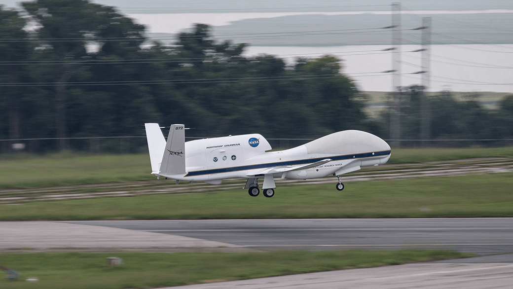
NASA’s Global Hawk unmanned aircraft completed the first two flights of its 2015 NOAA campaign when it flew above Tropical Storm Erika on August 26th and 29th. The Global Hawk used onboard instruments to profile the inner workings of Erika and released dropsondes to collect temperature, moisture, wind speed, and wind direction data. The real-time data were transmitted for the first time and incorporated into operational forecast models.
Other instruments aboard the Global Hawk, such as the microwave sounder from NASA’s Jet Propulsion Laboratory, gathered vertical profiles of temperature and humidity and was able to provide a unique view of Erika’s interaction with the Saharan Air Layer, a mass of dry air that inhibited Erika’s growth.
The Global Hawk, managed by NASA’s Armstrong Flight Research Center in California, provided a unique vantage point of Erika at 60,000 feet altitude, flying about 15,000 feet higher than NOAA’s G-IV jet. Both of its flights were 24 hours in length, nearly three times as long as that of the manned aircraft. The Global Hawk is part of NOAA’s Sensing Hazards with Operational Unmanned Technology (SHOUT) project, which seeks to improve hurricane forecasts of track and intensity using data collected by the unmanned aircraft from high in the stratosphere down to the ocean’s surface.
Below the ocean’s surface, another type of unmanned vehicle was in place, collecting data on Erika’s interaction with the upper level of the ocean as the storm passed through the Caribbean. AOML’s two underwater gliders traversed the waters off Puerto Rico, gathering temperature measurements that are critical to understanding the ocean’s role in how storms form, evolve, and change in intensity. These data should also provide researchers with a better understanding of the ocean’s response to the passage of storms which, in turn, will improve ocean models used in hurricane forecasts.
Data collected by NOAA’s hurricane hunter aircraft and the Global Hawk were uploaded in real-time to the Global Telecommunications System for inclusion in environmental models, better enabling researchers to predict the future activity and intensity of Danny and Erika.
 AOML is proud to announce the selection of Dr. James “Jim” Hendee as the director of its Ocean Chemistry and Ecosystems Division. Internationally recognized for his expertise in coral observing systems and data management, Jim’s almost 25-year tenure with AOML began in 1990 as a data manager for several ocean chemistry programs. Jim is well known for his ability to leverage resources to innovatively develop and inspire productive research teams. Jim steps into the role of director after serving in an acting capacity since June 2013.