Skip to Content

Category Archives: Events

AOML Scientists Featured in Special Women’s History Month Issue of Oceanography Magazine

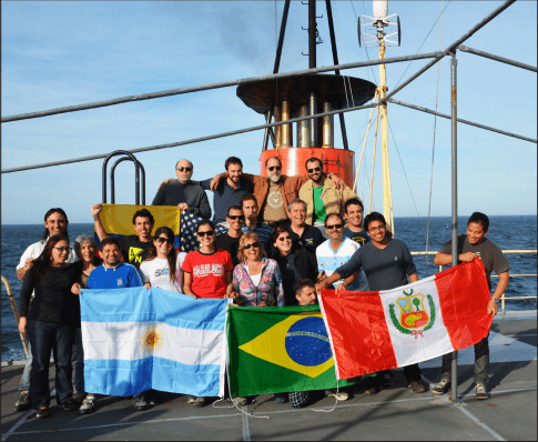
Women’s History Month is celebrated annually in March and pays tribute to the generations of women whose contributions made a historical impact on society. It is also a month to honor women who are currently working hard to make positive innovations and impressions on the world.

The Oceanography Society published a special issue of their magazine for 2015 Women’s History Month entitled “Women in Oceanography: a decade Later,” which features four of AOML’s female oceanographers.

The Oceanography Society’s feature includes statistics, women’s program descriptions, and one-page autobiographical sketches written by women oceanographers. It is the sequel to their first “Women in Oceanography” issue, released in 2005, dedicated to exploring why men outnumbered women at higher levels of the field.

This issue evaluates progresses made in retaining women in the oceanography field over the past decade. The article included over 200 autobiographical sketches, which highlighted AOML’s Libby (Elizabeth) Johns, Renellys C. Perez, Claudia Schmid, and Silvia L. Garzoli.

Click below to find out more about each scientist.

Libby (Elizabeth) Johns Oceanographer for the Physical Oceanography Division at AOML

Over the past decade, Libby has continued with her research in south Florida coastal oceanography and broadened her interests to include fisheries oceanography. As a woman in her chosen field, Libby faced a few challenges. First and foremost, the challenge of being a wonderful mother while continuing to excel at her professional career had her constantly adapting to life’s changes. Another challenge Libby faced was transitioning from strictly physical oceanography to interdisciplinary, applied oceanography.  Libby’s advice; “Do not settle for the status quo, but instead constantly evaluate the various parts of a happy and successful life so every aspect can compliment each other.”

Claudia Schmid Oceanographer for the Physical Oceanography Division at AOML

A combined love of the ocean, math and physics brought Claudia to the field of oceanography. Growing up, she spent summers mostly in or on the waters of the Mediterranean. Through her research projects, she achieved global data coverage with regular sampling. For Claudia this was a dream come true. It inspired her to become more involved with data management, co-principal investigator for the Argo project, and join the Prediction and Research Moored Array in the Tropical Atlantic project.

Silvia L. Garzoli Chief Scientists Emeritus at AOML & CIMAS

Over the past 10 years, Silvia transitioned through many life changes. From director of the Physical Oceanography Division (PhOD) at NOAA’s AOML, to Chief Scientist of AOML, to retirement and a part-time scientific position, Silvia witnessed positive changes in the challenges women in science face. When she was PhOD’s director she faced administrative and management challenges, including being a “woman boss,” During her time as director, PhOD greatly benefitted and received excellent reviews after an intensive external review process. Now Silvia works part time as a scientist in order to direct her energy toward writing papers and experiencing extended research cruises. Her advice; “Change is good. It is difficult, and scary, but good!”

Renellys C. Perez Associate Scientist for CIMAS and AOML

Renellys’s love of the ocean brought her to her current research, which is focused on developing a better understanding of ocean currents and their roles in ocean-atmospheric heat exchange. Her investigations require collaboration with other researchers around the world, which allows her to travel and conduct research at sea. This can sometimes be challenging because it involves time spent away from her husband and daughter. Being a woman in science required that Renellys be able to balance family and a career.  Renellys also had to overcome learning how to navigate the US science funding system. She plans on using the multitasking skills she developed in her family life and putting them to use at work, funding multiple projects simultaneously.

Originally published in March 2015 by Shannon Jones 

0 Continue Reading →

Drifter Program Catches a Lift to the Southern Ocean with the Volvo Ocean Race

If you’ve ever sailed aboard a ship in the coastal ocean, or checked a weather report before going to the beach, then you are one of many millions of people who benefit from ocean observations. NOAA collects ocean observations and weather data to provide mariners with accurate forecasts of seas, as well as coastal forecasts and even regional climate predictions. It takes a lot of effort to maintain observations in all of the ocean basins to support these forecasts, and NOAA certainly can’t do it alone. Partnerships are essential to maintaining a network of free-floating buoys, known as drifters, and NOAA’s latest partner is not your typical research or ocean transportation vessel: the six sailboats and crew currently racing around the world in the Volvo Ocean Race.

As one of the world’s major global sailing races, the Volvo Ocean Race greatly depends on accurate predictions of ocean currents and marine weather. All six of the Volvo Ocean Race teams will each deploy a drifter, a free-floating sensor that measures surface pressure and ocean currents and transmits the information by satellite to NOAA, during the fifth leg of the race, in the Southern Ocean – a region oceanographers don’t get to visit regularly, but one that is important to observe.

  • Sailors from Team Alvimedica deploy a drifter in the Southern Ocean.

    Image credit: Amory Ross/Volvo Ocean Race

  • Deployment site for drifters on Volvo Ocean Race 2014-2015 Route Map. Image Credit: Volvo Ocean Race and NOAA/AOML

Update from the Southern Ocean:

On March 20th, despite less than ideal conditions, sailors aboard the six sailing vessels successfully deployed drifters at target locations in the Southern Ocean.

Will Oxley, Team Alvimedica’s navigator, was excited to participate in the drifter deployment. Aside from being a top offshore sailor, Oxley is a marine biologist who recognizes the importance of data collection in the Southern Ocean.

“It’s believed the Southern Ocean absorbs up to about 60 percent of the heat and carbon dioxide produced by humans,” he explains. “So the Southern Ocean is a very important ‘sink’ that is absorbing carbon dioxide and slowing the pace of global warming.”

NOAA scientists will soon be receiving critical real-time data from some of the most remote waters on the planet. Access the drifter data online by clicking on the thumbnail.

Originally Published March 2015 by Shannon Jones

0 Continue Reading →

NOAA Selects Biscayne Bay for Next Habitat Blueprint Focus Area

NOAA has selected South Florida’s Biscayne Bay as one of the next Habitat Focus Areas under NOAA’s Habitat Blueprint. Habitat Blueprint offers opportunities for NOAA to partner with organizations to address coastal and marine habitat loss and degradation issues. It provides a framework, which builds upon existing programs, prioritizes activities, and helps users act strategically and preventively in order to sustain resilient and thriving marine and coastal ecosystems and resources.

OML is located on Virginia Key in south Florida, surrounded by the clear waters of Biscayne Bay. The bay provides a home for endangered species, seagrass nurseries, and feeding grounds for many valued fish. The bay’s clear waters also support regional economy, recreation, and tourism. In the past 20 years, scientists at AOML, Florida International University, Miami-Dade County Department of Environmental Resources Management, and South Florida Water Management District have observed a trend in increased concentrations of chlorophyll a, an index of phytoplankton abundance. Phytoplankton, also known as microalgae, are microscopic plants in the water column, requiring sunlight and nutrients to live. With increasing phytoplankton comes the potential for frequent algal blooms that damage seagrass beds by reducing the light available to seagrass.

The recorded increase in phytoplankton, coupled with the recent appearance of an expansive diatom bloom in the southern bay in 2013 and macroalgae overgrowing seagrass beds in the central bay is causing scientists to worry about the future of Biscayne Bay’s ecosystem. If phytoplankton continues to increase, the quality of Biscayne Bay’s clear, pristine water could decrease and seagrass could be be smothered causing a widespread loss that would be hard to halt or reverse.


  • Biscayne Bay’s mangroves provide shelter near seagrass nurseries for many
    valued species. Photo Credit: NOAA

  • Miami residents enjoy a beautiful sunset over Biscayne Bay. Photo Credit: NOAA/AOML

  • An aerial view of Boca Chita Key surrounded by Biscayne Bay.
    Photo Credit: National Park Service

AOML’s Chris Kelble is co-leading the implementation team with NOAA Southeast Fisheries Science Center’s Joan Browder in hopes of identifying solutions to improve Biscayne Bay health, before it declines. With the help of NOAA’s Habitat Blueprint, partnering organizations can develop assessments, experiments and analyses to ultimately protect, restore, and sustain Biscayne Bay’s healthy ecosystem.

Habitat Blueprint is providing grant opportunities for restoration projects in NOAA’s new Habitat focus areas. Up to $1.2 million is expected to be available to support comprehensive and cooperative habitat conservations projects in areas including Biscayne Bay, FL. Habitat Blueprints goal is to have projects that sustain resilient and thriving marine and coastal resources, communities, and economies. Interested parties must apply and submit proposals that address the unique, site-specific objectives and issues/concerns that have been identified for Biscayne Bay, in hopes of restoring degraded areas, protecting environmental habitats, and fostering resilient coastal communities.

Originally Published in January 2015 by Shannon Jones

0 Continue Reading →

AOML Selects Coral Researcher, Jim Hendee, to Lead Ocean Chemistry & Ecosystems Research

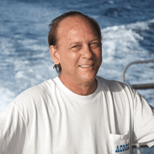
AOML is proud to announce the selection of Dr. James “Jim” Hendee as the director of its Ocean Chemistry and Ecosystems Division. Internationally recognized for his expertise in coral observing systems and data management, Jim’s almost 25-year tenure with AOML began in 1990 as a data manager for several ocean chemistry programs. Jim is well known for his ability to leverage resources to innovatively develop and inspire productive research teams. Jim steps into the role of director after serving in an acting capacity since June 2013.

Jim’s early career at AOML blossomed as he oversaw data management of the newly established SEAKEYS program, a network of lighthouses and other platforms that collect hourly in situ sea temperature and meteorological data at coral reef sites along the Florida Keys.  Jim initially gathered SEAKEYS data and distributed it daily via fax (“Coral Fax”) to environmental managers in the Florida Keys, as well as to dive boat and fishing charters. Seeing an opportunity to embrace emerging technology and the burgeoning Internet, Jim successfully launched the  “Coral Health and Monitoring Program” (CHAMP) to start the very first coral reef related Web page, and one of the first 3,000 Web sites in the world. The server was also used to host a list-server called Coral-List with about 100 names taken from the attendee list for the 8th International Coral Reef Symposium in Panama.  That list still operates today with over 8,500 subscribers and has become the de facto means of broad communication among coral reef researchers the world over.

In 1998 Jim was chosen as one of the members of the newly established U.S. Coral Reef Task Force Monitoring Working Group.  Jim and his growing team of NOAA oceanographers eventually devised a new design for in situ coral reef monitoring and began installing the design at coral reef sites in the Caribbean, with funding help from NOAA’s newly formed Coral Reef Conservation Program.

Through the years the CHAMP program has received over $8 million for coral reef research and to develop the expert system that is the heart of the CREWS ecological forecasting system. Jim’s efforts have supported acquisition of an appreciable amount of computing hardware and software, oceanographic and meteorological instrumentation, and supported five major international workshops.  Jim also leverages the continuing CHAMP funds to establish and support new research directions (e.g., ocean acidification, ecological forecasting, physical oceanography of coral reefs) and personnel support for research scientists and system administrators, five National Research Council post-docs, and numerous Hollings Scholars and student interns.

From 1993 to 2000, Jim worked nights to earn a Ph.D. in Information Systems from Nova Southeastern University. His previous degrees include a B.S. and M.S. in marine biology.  In 2000, Jim received the NOAA Research Employee of the Year award, and in 2005 the NOAA Bronze medal for establishing the CREWS Network.

Originally Published in February 2015 by Shannon Jones

0 Continue Reading →

The Galápagos Islands: A Glimpse into the Future of Our Oceans

A study of Galápagos’ coral reefs provides evidence that reefs exposed to lower pH and higher nutrient levels may be the most affected and least resilient to changes in climate and ocean chemistry.

The Galápagos Islands are a unique habitat that allows scientists to study many ecological conditions, including exposure to naturally high levels of oceanic carbon dioxide. The coasts of the Galápagos are bathed in upwelled water from the deep ocean. This upwelled water has high carbon dioxide concentrations. Greater levels of carbon dioxide result in lower pH levels in seawater, making it more acidic.  Waters with high carbon dioxide can have negative affects on some organisms, like corals, that build their skeletons underwater. These naturally high levels of carbon dioxide surrounding the Galápagos are a present day example of the conditions expected throughout the rest of the tropics by the 2050’s.

Warm water temperatures are another factor affecting the Galápagos. The 1982-1983 El Niño Southern Oscillation warming event increased water temperatures in the Galápagos 3-4 degrees C above the usual maximum sea temperatures.  This warming physically stressed Galápagos corals, causing them to expel the algae living in their tissues and become completely white or bleached. This and other similar coral bleaching events coupled with the naturally occurring high levels of carbon dioxide, made it difficult for coral reefs to rebuild their calcium carbonate skeletons.  None of the Galápagos’ southern reefs show signs of revival and the only reef recovering is off the far northern island, Darwin.

As a coral ecologist and lead researcher for NOAA’s National Coral Reef Monitoring Program, Derek Manzello gathered an abundance of data on the seawater surrounding the southern Galápagos Islands, but he had limited information on the seawater in the northern islands. Thanks to the Khaled bin Sultan Living Ocean’s Foundation, Manzello and his team were able to venture to Darwin and conduct field studies comparing corals and seawater chemistry between the southern and northern islands. They discovered that at the present day acidification levels, corals can recover from severely stressful events, but their recovery is dependent on water quality conditions.

In the Galápagos study, waters have lower pH and higher nutrients in the southern Islands.  The team measured changes in coral density to compare growth rates of corals in the southern and northern waters. Corals, like trees, have an annual banding pattern, which is used to determine annual growth rates. Manzello’s team took core samples from corals, and examined their density bands with a micro-CT scanner, producing three-dimensional X-ray images.  Using these images, scientists observed healthier annual growth rates and density patterns for corals in the northern waters.  Corals in the southern waters, which were exposed to elevated nutrients and high CO2 levels due to upwelling, showed less skeletal growth.

“The Galápagos reefs provide one piece of the science of predicting how coral reefs will fare with continued warming and ocean acidification.” Says Manzello “There are other areas with high levels of carbon dioxide that do not experience as high of nutrient values as the Galápagos. This allows us to understand how acidification may impact the future of coral reefs through the worlds oceans.”

With support from NOAA’s Coral Reef Conservation and Ocean Acidification Programs, NOAA oceanographers can continuously evaluate, monitor, and study the effects of ocean acidification. Learn more about AOML’s collaborative ocean acidification efforts in the Island of Maug and the Florida Keys.

  • Only one surviving reef off the coast of Darwin Island in the northern Galápagos Islands.
    Photo Credit: Joshua Feingold

  • Coral Reefs off the coast of Floreana Island in the Galápagos Islands photographed in 1976, before the 1982-1983 El Niño Southern Oscillation warming event. Photo Credit: Peter Flynn

  • Coral reefs off the coast of Floreana Island in the Galapagos Islands photographed in 2012, after stressful environmental conditions destroyed the reef. Photo Credit: Derek Manzello

Originally Published in January 2015 by Shannon Jones

0 Continue Reading →

NOAA and Partners Host Open House for 1,300

NOAA’s Atlantic Oceanographic and Meteorological Laboratory (AOML) and the National Marine Fisheries Service/Southeast Fisheries Science Center (SEFSC) partnered with the University of Miami Rosenstiel School for Marine and Atmospheric Science and the Maritime and Science Technology (MAST) Academy to host an open house May 14th-16th. The three day event brought an estimated 1,300 people to Virginia Key to learn about a variety of scientific topics including hurricane research, climate science, oceanography, local fisheries, coral communities, and endangered species. NOAA and UM scientists were on-hand to describe their research projects, conduct hands-on experiments, and answer questions.

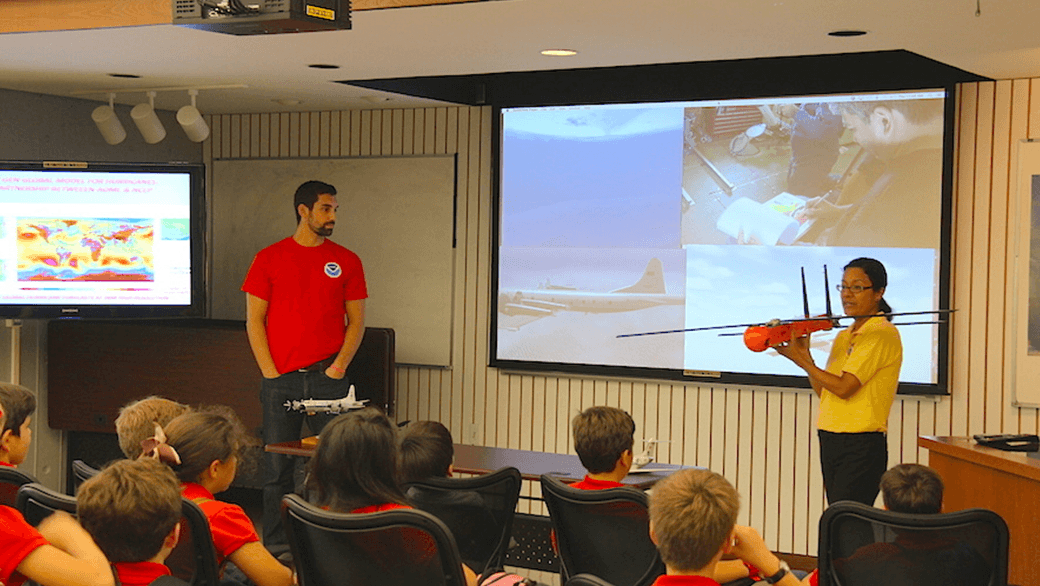
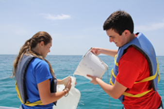
Over 700 students from fourteen local schools participated in the event. Small groups toured AOML, SEFSC, the MAST Academy Land SHARC and Weather on Wheels mobile outreach programs and the University of Miami’s new Marine Technology and Life Sciences Seawater Complex. Doors were then opened up to the public on Saturday, May 16th. Saturday’s event was an interactive experience for all age groups, with visitors rotating throughout each NOAA facility, the MAST mobile outreach buses, and the University of Miami Rosenstiel School’s experimental hatchery. Among the visitors were over 225 boy scouts and girl scouts from local troops, each of whom earned a special science patch for their participation in the event. school groups enjoyed the open house on Thursday and Friday, May 14th-15th.

This event brought marine and atmospheric science to the community and further enhanced Science, Technology, Engineering and Math (STEM) education. We’d like to thank all participants as well as our dedicated staff and volunteers for making this such an exciting event!


Originally Published in January 2015 by Shannon Jones

0 Continue Reading →

Meridional Overturning Circulation: Following the Heat

Deployment of a PIES mooring in the South Atlantic. Photo credit: NOAA/AOML

If you want to understand Earth’s climate and how it changes from year-to-year and decade-to-decade, look to the oceans, and follow the heat. The major driver in the redistribution of heat around the globe in the ocean-climate system is Meridional Overturning Circulation, or MOC. The MOC is a vertical circulation pattern that exchanges surface and deep waters via poleward movement of surface waters. As an example, the well known Gulf Stream on the eastern seaboard of North America carries warm water northward to the Greenland and Norwegian Seas, where it cools and sinks.

Scientists with AOML’s Physical Oceanography Division joined with partners from Argentina and Brazil in October to study the MOC at 34.5°S in the South Atlantic. On board the Argentine research vessel ARA Puerto Deseado, researchers united for the ninth joint cruise undertaken in support of the NOAA-funded Southwest Atlantic MOC (SAM) project since March 2009. Participants included researchers from the Universidade de Buenos Aires, the Servicio de Hidrografía Naval, the Instituto Nacional de Investigación y Desarrollo Pesquero, the Universidade Federal do Rio Grande, and the Universidade de Sao Paulo, as well as NOAA-AOML.

The MOC sinks at high latitudes and upwells elsewhere. Its variability is linked in numerical models to significant changes in precipitation patterns, surface air temperatures, and hurricane intensity over large portions of the Earth. NOAA-AOML serves in a leading role with its partners to collect observations of the South Atlantic portion of the global MOC system to gain a more complete understanding of its complex nature. A complete trans-basin instrument array to measure the MOC at 34.5°S is in the process of deployment, and NOAA instruments near the western boundary are the cornerstone of the full array.

On this fall 2014 cruise, scientists used ship-based instruments to acoustically download data from four pressure-equipped inverted echo sounder (PIES) moorings in the SAM array, as well as two similar Brazilian instruments. These instruments send sound pulses from their position near the ocean floor to the sea surface and listen for the return of the reflected sound waves. The round-trip acoustic travel time measurements are then combined with historical hydrographic data to obtain daily estimates of the temperature, salinity, and density for the full water column above the mooring. Meanwhile, the pressure gauges provide information on the variability of deep-water flows. The combination of data sets from the PIES moorings provides long-term observations of the shallow and deep western boundary currents at 34.5°S, key components in the MOC system.

The existing array is scheduled to continue through at least 2016, with annual or semi-annual cruises planned to collect new hydrographic information and acoustically download data from the array. NOAA’s contribution to this effort is funded by the Climate Program Office/Climate Observations Division and by AOML.

Originally Published in November 2014 by Shannon Jones

0 Continue Reading →

Atlantic Hurricane Season Remains Quiet As Predicted

Improved model, new surge forecast products and research projects debuted


The Atlantic hurricane season will officially end November 30, and will be remembered as a relatively quiet season as was predicted. Still, the season afforded NOAA scientists with opportunities to produce new forecast products, showcase successful modeling advancements, and conduct research to benefit future forecasts.

“Fortunately, much of the U.S. coastline was spared this year with only one landfalling hurricane along the East Coast. Nevertheless, we know that’s not always going to be the case,” said Louis Uccellini, Ph.D., director of NOAA’s National Weather Service. “The ‘off season’ between now and the start of next year’s hurricane season is the best time for communities to refine their response plans and for businesses and individuals to make sure they’re prepared for any potential storm.”

How the Atlantic Basin seasonal outlooks from NOAA’s Climate Prediction Center verified:


Actual

August Outlook

May Outlook

Named storms (top winds of 39 mph or higher)

8

7-12

8-13

Hurricanes (top winds of 74 mph or higher)

6

3-6

3-6

Major hurricanes (Category 3, 4, 5; winds of at least 111 mph)

2

0-2

1-2


“A combination of atmospheric conditions acted to suppress the Atlantic hurricane season, including very strong vertical wind shear, combined with increased atmospheric stability, stronger sinking motion and drier air across the tropical Atlantic,” said Gerry Bell, Ph.D., lead hurricane forecaster at NOAA’s Climate Prediction Center. “Also, the West African monsoon was near- to below average, making it more difficult for African easterly waves to develop.”

Meanwhile, the eastern North Pacific hurricane season met or exceded expectations with 20 named storms – the busiest since 1992. Of those, 14 became hurricanes and eight were major hurricanes. NOAA’s seasonal hurricane outlook called for 14 to 20 named storms, including seven to 11 hurricanes, of which three to six were expected to become major hurricanes. Two hurricanes (Odile and Simon) brought much-needed moisture to the parts of the southwestern U.S., with very heavy rain from Simon causing flooding in some areas.

“Conditions that favored an above-normal eastern Pacific hurricane season included weak vertical wind shear, exceptionally moist and unstable air, and a strong ridge of high pressure in the upper atmosphere that helped to keep storms in a conducive environment for extended periods,” added Bell.

In the central North Pacific hurricane basin, there were five named storms (four hurricanes, including a major hurricane, and one tropical storm). NOAA’s seasonal hurricane outlook called for four to seven tropical cyclones to affect the central Pacific this season. The most notable storm was major Hurricane Iselle, which hit the Big Island of Hawaii in early August as a tropical storm, and was the first tropical cyclone to make landfall in the main Hawaiian Islands since Hurricane Iniki in 1992. Hurricane Ana was also notable in that it was the longest-lived tropical cyclone (13 days) of the season and the longest-lived central Pacific storm of the satellite era.


New & improved products this year

As part of its efforts to provide better products and services, NOAA’s National Weather Service introduced many new and experimental products that are already paying off.

The upgrade of the Hurricane Weather Research and Forecasting (HWRF) model in June with increased vertical resolution and improved physics produced excellent forecasts for Hurricane Arthur’s landfall in the Outer Banks of North Carolina, and provided outstanding track forecasts in the Atlantic basin through the season. The model, developed by NOAA researchers including AOML’s Hurrican Research Division, is also providing guidance on tropical cyclones in other basins globally, including the Western Pacific and North Indian Ocean basins, benefiting the Joint Typhoon Warning Center and several international operational forecast agencies. The Global Forecast System (GFS) model has also been a valuable tool over the last couple of hurricane seasons, providing excellent guidance in track forecasts out to 120 hours.

In 2014, NOAA’s National Hurricane Center introduced an experimental five-day Graphical Tropical Weather Outlook to accompany its text product for both the Atlantic and eastern North Pacific basins. The new graphics indicate the likelihood of development and the potential formation areas of new tropical cyclones during the next five days. NHC also introduced an experimental Potential Storm Surge Flooding Map for those areas along the Gulf and Atlantic coasts of the United States at risk of storm surge from an approaching tropical cyclone. First used on July 1 as a strengthening Tropical Storm Arthur targeted the North Carolina coastline, the map highlights those geographical areas where inundation from storm surge could occur and the height above ground that the water could reach.

Beginning with the 2015 hurricane season, NHC plans to offer a real-time experimental storm surge watch/warning graphic for areas along the Gulf and Atlantic coasts of the United States where there is a danger of life-threatening storm surge inundation from an approaching tropical cyclone.


Fostering further improvements

While this year’s hurricane season was relatively quiet, NOAA scientists used new tools that have the potential to improve hurricane track and intensity forecasts. Several of these tools resulted from research projects supported by the Disaster Relief Appropriations Act of 2013, which was passed by Congress in the wake of Hurricane Sandy.

Among the highlights were successful manned and unmanned aircraft missions into Atlantic hurricanes to collect data and evaluate forecast models. NOAA and NASA’s missions involving the Global Hawk, an unmanned aircraft that flies at higher altitudes and for longer periods of time than manned aircraft, allowed scientists to sample weather information off the west coast of Africa where hurricanes form, and also to investigate Hurricane Edouard’s inner core with eight crossings over the hurricane’s eye. NOAA launched a three-year project to assess the impact of data collected by the Global Hawk on forecast models and to design sampling strategies to improve model forecasts of hurricane track and intensity.

While the Global Hawk flew high above hurricanes, NOAA used the much smaller Coyote, an unmanned aircraft system released from NOAA’s hurricane hunter manned aircraft, to collect wind, temperature and other weather data in hurricane force winds at much lower altitudes during Edouard. The Coyote flew into areas of the storm that would be too dangerous for manned aircraft, sampling weather in and around the eyewall at very low altitudes. In addition, NOAA’s hurricane hunters gathered data in Hurricanes Arthur, Bertha and Cristobal, providing information to improve forecasts and to test, refine and improve forecast models. The missions were directed by research meteorologists from AOML’s Hurricane Research Division, and the NOAA Aircraft Operations Center in Tampa.

In addition, increased research and operational computing capacity planned in 2015 will facilitate future model upgrades to the GFS and HWRF to include better model physics and higher resolution predictions. These upgraded models will provide improved guidance to forecasters leading to better hurricane track and intensity predictions.

The 2015 hurricane season begins June 1 for the Atlantic Basin and central North Pacific, and on May 15 for the eastern North Pacific. NOAA will issue seasonal outlooks for all three basins in May. Learn how to prepare at hurricanes.gov/prepare and FEMA’s Ready.gov. NOAA’s mission is to understand and predict changes in the Earth’s environment, from the depths of the ocean to the surface of the sun, and to conserve and manage our coastal and marine resources.

  • 2014 Atlantic Hurricane Season 

  • NASA’s Global Hawk and the flight pattern created by AOML hurricane researchers to observer Hurricane Edouard. Image credit: NASA


  • The flight crew of the successful test launch of the Coyote Unmanned Aerial System. Image credit: NOAA

Originally Published November 2014 by Shannon Jones

0 Continue Reading →

Summer Interns Help Create a Hands-on Outreach Demonstration

Three MAST Academy Interns Designing Outreach Activity

MAST Academy interns Arturo Toro, Michelle Mestres, and Ryan Winslow from MAST Academy set up the experiment to illustrate some of the effects of changing salinity on density and the buoyancy of objects. (credit: NOAA/AOML)


Three summer interns collaborated with AOML’s Physical Oceanography Division to develop a hands-on outreach demonstration experiment that will be a useful tool to educate future visiting K-12 students. The students presented their demonstrations and associated research as a conclusion to their 8 week-long summer internship with NOAA scientists at AOML. The students attend MAST Academy, a Maritime and Science Technology magnet high school in Miami-Dade county co-located with AOML on Virginia Key. The interns’ experiment illustrates some of the effects of changing salinity on density and the buoyancy of objects. It will help teach students about topics in physical oceanography such as the Atlantic Meridional Overturning Circulation (AMOC), the Mediterranean Sea outflow, and how floats, drifters, and gliders use density and buoyancy to determine their positions in the water column.

Green Dyed Salty and Fresh Water

Saltier (denser) water (colored green) forms a layer underneath the fresher (lighter) water after the stoppers are removed from the center divider. (credit: NOAA/AOML)

To begin the demonstration, the interns first divided a rectangular fish tank into two halves using a plexiglass panel with closed stoppers in holes near the top and bottom.  One half was filled with room temperature salt water, while the other half was filled with warm fresh water.  They dropped objects of varying densities into the divided tank in order to see which would float, and which would sink.  For example, a small flask filled with fresh water sank to the bottom of the lighter fresh water but floated on top of the denser salt water.  After using green food coloring to mark the denser salt water, the interns then removed both stoppers. This created a simple overturning circulation effect, where water flowed from the fresh to salty side of the tank through a hole near the top, and flowed from the salty to fresh side of the tank through the hole near the bottom. Eventually, the circulation resulted in a layer of fresh water lying above a layer of salt water.

Popped water balloon mixed with salt and fresh water to create brackish water.

A small flask filled with fresh water and a small amount of air released at the top of the tank floats near the interface between the fresher (lighter) and saltier (denser) layers.  Heavier flasks filled completely with fresh or salty water sink to the bottom on both sides of the tank.   (credit: NOAA/AOML)

The interns then dropped flask filled with fresh water into either side of the tank, they observed it dropping through the fresh water and floating at the top of the salt-water layer.  To further illustrate this effect, a balloon filled with warm, lighter fresh water and red food coloring was placed into the tank and held near the bottom.  When the balloon was popped in the lower layer, the colored water mixed with the surrounding salt water, becoming brackish, and rose part way to the surface, finally settling at the saltwater-freshwater interface.

“The balloon popping is my favorite part,” said Ryan Winslow, one of the MAST interns. “It shows how the liquid is dispersed in a random pattern but then reorganizes itself to create a medium between the two types of water”


In future repetitions of these experiments more precise measurements of the temperature and salinity of the water could be made, allowing for a better means of calculating the density differences between the water in the tank and in the various objects used.  During the buoyancy experiments, scientists could also better account for the effects of the weight of the objects (jars, balloons, etc.) themselves and any air that was contained within them.


In addition to their outreach demonstration, facilitated by AOML oceanographer Renellys Perez and ocean engineers Grant Rawson and Andy Stephanick,  the three interns worked with other PhOD scientists this summer to learn about some of the research conducted by the division. Michelle Mestres worked with Gustavo Goni and Libby Johns to learn about the emerging field of Glider technology. Ryan Winslow interned with Molly Baringer and examined ways in which data from the Repeat Hydrography program can be used to study heat content in the ocean. Arturo Toro assisted the engineering group with a variety of ongoing projects.

Ryan Winslow's end of the summer presentation.

Intern, Ryan Winslow, gives a powerpoint presentation on his project and
explains what he learned durning his summer at AOML. (credit: NOAA/AOML)


Originally Published August 2014 by Shannon Jones

0 Continue Reading →

NOAA Participates in International Ocean Sampling for Microbes

NOAA’s Atlantic Oceanographic and Meteorological Laboratory (AOML) participated in Ocean Sampling Day on June 21, the first global simultaneous sampling for microbes in ocean, coastal and Great Lakes waters. Over time, sampling will support international and NOAA missions to provide a snapshot of the diversity of microbes, their functions, and their potential economic benefits. Among other economic applications, microbes have been used for novel medicines, as biofuels, and to consume spilled oil. Organized and led by the European Union’s MicroB3 organization, NOAA coordinated twelve sampling sites for Ocean Sampling Day 2014 within U.S. coastal waters.

sampling in La Jolla, CA

AOML scientists Kelly Goodwin enters data from water samples from La Jolla, CA.

“Small organisms make up the majority of the ocean’s biomass and drive the cycles that sustain life on earth, but not until recently have we had the tools to reveal their diversity and function,” said Kelly Goodwin, a microbiologist at AOML. “Ocean Sampling Day and future efforts in Genomic Observatories will employ state-of-the art ‘omic technologies to uncover how the oceans are adapting to a multitude of stressors and how those changes translate up to ecosystem services – including seafood supply and healthy swimming waters and coastal habitats.”

NOAA’s Marine Microbes Working Group coordinated 12 sampling locations, part of more than 150 international sites, and supported cross-line NOAA efforts to include NOAA Research centers, including AOML, NOAA Fisheries centers, and NOAA’s National Ocean Service Sanctuary locations (Grays Reef and Humpback Whale National Marine Sanctuaries). NOAA’s Office of Ocean Exploration and Research coordinated the broader NOAA science and outreach/education aspects. Sampling sites are expected to be monitored long-term as part of the international ocean Genomic Observatories Network and the database will serve as a baseline, accessible to the research community, industry, policy makers and the public. The Smithsonian’s Global Genome Initiative will archive samples.

AOML staff, with support from a cadre of summer interns, coordinated five locations in south Florida and in California. Sites included Port Everglades, Tennessee Reef offshore of Long Key in the Florida Keys National Marine Sanctuary, and near the mouth of Tampa Bay at Fort DeSoto in Saint Petersburg. AOML collaborators from the University of Southern Mississippi conducted sampling at Horn Island offshore of the Mississippi Coast. AOML scientists also coordinated the sampling the OSD site at the Scripps Institute Pier in La Jolla, California.

FL Keys OSD sample collection

AOML student interns collect samples from the Florida Keys

Citizen Scientists all over the world also collected environmental data (water and air temperature, salinity, oxygen, etc.) to support the microbial sampling collected globally on the summer solstice. In La Jolla, CA, one of AOML’s remote employees worked with a local scout troop to guide them in collecting similar environmental data. These local efforts were designed to raise general awareness about Ocean Sampling Day.

0 Continue Reading →