Skip to Content

Category Archives: Events

AOML Oceanographers Collect Coast to Coast Measurements on the GO-SHIP Indian Ocean Cruise

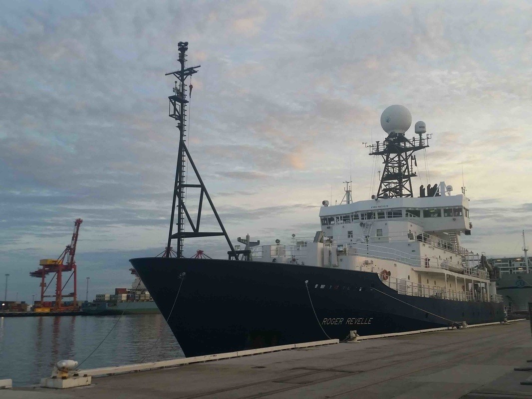
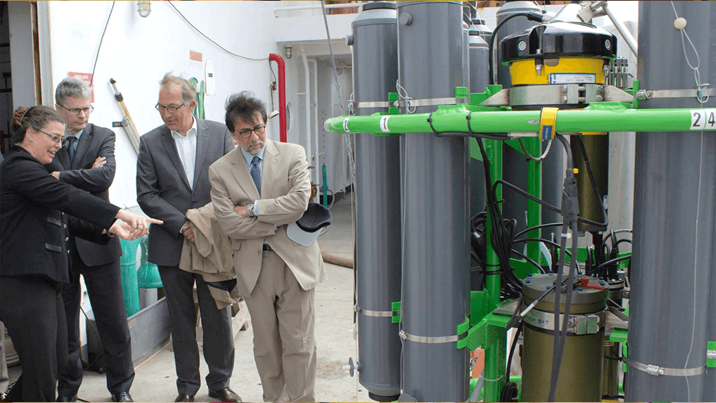
During the months of March and April, AOML joined an international team of oceanographers to actively sample the Indian Ocean in support of the Global Ocean Ship-Based Hydrographic Investigation Program (GO-SHIP), an initiative to measure and investigate the ocean basins from coast to coast and from top to bottom. Aboard the R/V Roger Revelle, the team transected the Indian Ocean from the Antarctic northward into the Bay of Bengal, collecting seawater samples at 113 stations as part of a multi-decadal effort to measure various ocean properties, including temperature, salinity, nutrients, carbon and other gases.

0 Continue Reading →

NOAA and Cuba Open Doors to Marine Science Cooperation

When Barack Obama becomes the first president to visit Cuba since Calvin Coolidge, his visit will highlight not only a new course in international relations, but showcase on-going scientific opportunities with the country only 90 miles off the Florida coast.

0 Continue Reading →

10th Anniversary of Hurricane Katrina

Early on the morning of August 29th, 2005, Hurricane Katrina made landfall on the Louisiana delta region and the Mississippi coast.  The storm surge brought enormous damage to the Gulf Coast and, when the levees around New Orleans failed, a great number of fatalities.  Coming amidst the very busy 2005 hurricane season, Katrina brought death and destruction not seen in a U.S. land-falling hurricane in decades.

0 Continue Reading →

Behind the 2015 Atlantic Hurricane Season: Wind Shear & Tropical Cyclones

Wind Shear
No Wind Shear

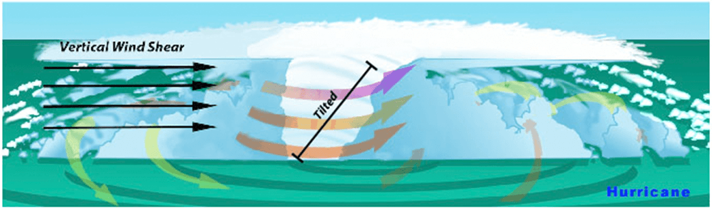
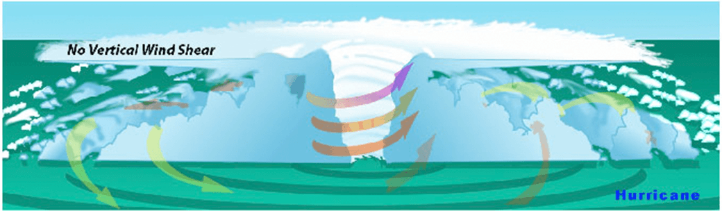
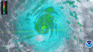
In the presence of vertical wind shear, a storm’s core structure will be tilted in relationship to the wind shear. This tilting will disrupt the flow of heat and moisture which inhibits the storm from developing and becoming stronger.

With the 2015 Atlantic hurricane season underway, researchers are pointing to the strong presence of El Niño as the major driver suppressing the development of tropical cyclones in the Atlantic basin. But what specific conditions are associated with El Niño that lead to a less than ideal environment for tropical cyclone development? Through research and observation, hurricane researchers know strong environmental wind shear is a major factor affecting potential hurricane development and growth. This hurricane season, AOML researchers are delving further into the relationship between wind shear and tropical cyclones.

What is wind shear?

Wind shear is the variation of the wind’s speed or direction over a short distance within the atmosphere. For tropical cyclones, wind shear is important primarily in the vertical direction, as these storms occupy a large vertical slice of the atmosphere from sea level to the top of the troposphere, which extends up to about 40,000 feet altitude in the tropics in summer.

How does wind shear affect tropical cyclone development?

Tropical weather systems are vulnerable to changes in the broader atmosphere surrounding them; often influenced by large features such as areas of high and low pressure, and fronts. If there’s too much wind, these weather systems have trouble organizing and developing into a tropical cyclone. As a tropical system forms, heavy thunderstorms build near the center. Given the right environment, these systems can eventually begin turning counter-clockwise (or cyclonically) in the northern hemisphere. With little to no wind shear, the turning within the tropical system is uniform and the storm becomes vertically aligned, helping to keep it intact and, likely, strengthening.

The most favorable condition for tropical cyclone development is the absence of wind shear. When wind shear is present, however, a storm’s core structure becomes vertically tilted in relationship to the wind shear, disrupting the flow of heat and moisture. Tropical cyclones are heat engines powered by the massive heat release associated with water vapor condensing into liquid water. Vertically-tilted systems are less efficient at drawing in warm and moist air from the surrounding ocean and will be less likely to develop and strengthen.

How does El Niño affect the presence or absence of wind shear?

El Niño is a climate phenomenon driven by above average ocean temperatures in the central and eastern tropical Pacific. While that warmth helps boost Pacific storm activity, the extra heat transferred to the atmosphere leads to a domino effect, altering climate around the globe.

Specifically, the instability over the warm equatorial Pacific during El Niño creates changes in the jet stream over the Northern Hemisphere, resulting in decreased wind shear in the Pacific and increased wind shear across much of the Caribbean and Atlantic. El Niño also increases the atmospheric stability, or resistance of the atmosphere to vertical motion, in the Atlantic basin, which suppresses hurricane activity.

Can a storm persist despite the existence of wind shear?

AOML researchers are focusing on particular characteristics of developed tropical cyclones that enable them to persist despite increased levels of wind shear. The theoretical work focuses mainly on how a tropical cyclone’s wind structure is disrupted by wind shear.

Using a simple mathematical model, researchers can estimate the degree to which the center of the storm becomes vertically tilted based on the cloudiness within the eyewall, as well as the structure of the wind outside the eyewall. By modeling the development of storm tilt, a better understanding of a tropical cyclone’s behavior is gained in the presence and absence of wind shear.

Results suggest that tropical cyclones are more likely to resist disruption by vertical wind shear when clouds cover a large portion of the eyewall and when winds decrease less rapidly from the eye. These model simulations show promise in understanding the fundamental physical processes driving intensity and structural changes of tropical cyclones due to environmental factors.

Model results suggest certain features such as cloudiness within the eyewall as well as the structure of the wind outside the eyewall may determine a storm’s level of resistance to wind shear.

A Doppler wind lidar instrument added to NOAA’s hurricane hunter aircraft this season will assist AOML researchers in collecting observational data to better understand the wind environment around tropical cyclones. The lidar instrument is used to collect, process, and transmit atmospheric data from within a hurricane, enabling NOAA to sample the winds inside the eyewall of storms. By leveraging observational expertise and new data combined with modeling, AOML researchers hope to learn more about the wind environment and the interaction between wind shear and tropical cyclones, allowing them to better predict a hurricane’s future activity and intensity.

Originally Published by Edward Pritchard, AOML

0 Continue Reading →

AOML Welcomes Aboard Summer 2015 Interns

AOML welcomes 22 young men and women, including new and returning high school, undergraduate, and graduate students, who are completing internships at the lab this summer. Over the course of their six to ten week internships, students will work with mentors in the fields of Ocean Chemistry & Ecosystems, Physical Oceanography, and Hurricane Research, as well as specialists in Computer Networks and Services, Administration, and Communications, to participate in field sampling efforts, perform data analysis, and create new content for internal and external websites.

AOML’s internship opportunities provide students with experiences that motivate and prepare them for careers aligned with NOAA and its industry and university partners. For many students, these internships are unique experiences that provide an opportunity to learn from some of the nation’s leading scientists. They participate in activities that support ongoing AOML research, and sometimes create new opportunities that become the foundation for their first scientific publication.

Each intern works alongside their AOML mentor to conduct research activities that match their educational interests and background. Their assigned work includes experimental data collection and processing, equipment design and testing, field research, and computer software and web content development. Some of the specific internship projects this summer include:

  • water quality field sampling efforts and use of molecular techniques to assess and characterize microbial contaminants;
  • examining particular storm characteristics that influence hurricane development in an effort to improve hurricane intensity forecasts; and
  • observing and modeling climate fluctuations in the central and northeastern Tropical Atlantic.

Many of these projects are at the cutting edge of science and technology, and all are important to future NOAA research efforts.

The group of talented students hails from local Miami-Dade high schools and higher learning institutions such as MAST Academy, G. Holmes Braddock Senior High School, Miami-Dade College, and the University of Miami, as well as other U.S. and International universities. The group also contains three undergraduates from the prestigious Hollings Scholarship Program. Administered by NOAA, the program provides support and multidisciplinary learning experiences for undergraduate students interested in pursuing research, public service, or teaching careers in the oceanic and atmospheric sciences.

0 Continue Reading →

AOML Oceanographers to Participate in New Summer Lecture Series

This summer, AOML will be diving into a new outreach initiative with the Central Caribbean Marine Institute, a coral reef research organization based in the Cayman Islands. From June through August, NOAA oceanographers from AOML will give a series of talks on various oceanographic topics to the institute’s staff and students participating in the National Science Foundation’s (NSF) Research Experiences for Undergraduates program at the institute’s Little Cayman Research Centre (LCRC).

Central Caribbean Marine Institute is a non-profit organization whose mission is to conduct and facilitate research, education, outreach and conservation programs that will sustain marine diversity. They support key research into addressing global issues such as climate change, marine protection, fisheries management and coral reef impacts. Every summer, the institute hosts undergraduate students at the LCRC as part of the NSF funded research program. Students work with mentors to design, implement, and present research projects within the institute’s research themes of coral reef stress, climate change, ocean acidification, and coral reef resilience and restoration.

This lecture series provides students with an opportunity to gain insight into current coral reef research programs in order to help them refine their summer projects. The series also offers networking opportunities for students and staff and fosters relationships with the AOML research community. Topics will range from ocean-reef interactions, microbiology, ecosystem-based management, and impacts to coral health. Funding for the lecture series is being provided by CCMI.

“I always get bored with minute-detail subjects like molecular studies, but Dr. Chris Kelble’s lecture on the science to inform ecosystem-based management was all about the bigger picture. It’s a topic that I would love to get into,” said Brian Griffiths, an REU student from the University of Delaware. “Dr. Kelble was the first scientist I’ve encountered so far that thinks like I do. He was a great role model to have met!”

In addition to providing lectures, NOAA oceanographers will be teaming up with CCMI scientists and the National Centers for Environmental Information to examine variations of temperature and light at the local scale over the coral reefs surrounding Little Cayman Island. Collecting and analyzing this important data will enhance NOAA’s coral reef ecological forecasting tools and help evaluate the adequacy of regional-scale observations in monitoring for environmental threats to the reefs. This data will also assist other research projects being carried out by various research groups on the Little Cayman reefs including projects focused on constructing a global climate record using coral core samples, connecting water conditions to algal growth on the reefs, and investigating why some reefs are more resilient than others over small distances.

Located on Little Cayman Island, the LCRC is situated next to some of the most biologically diverse reef systems on earth. These reefs are particularly important to coral reef scientists as they are largely unaffected by local human and development impacts. This isn’t the first time NOAA oceanographers will collaborate with the Little Cayman-based research center. NOAA’s Coral Reef Early Warning System (CREWS) established a monitoring station on the reef adjacent to the research center in 2009. CREWS stations are scattered across the Caribbean and contain a suite of oceanographic and atmospheric sensors that monitor environmental conditions in an effort to provide scientists with early warning of climate-related events such as coral bleaching.

See below for a complete schedule of the lecture series:

June 23 – 29

– “Synergistic Effects of Eutrophication and Elevated SST in the Early Life Stages of Two Caribbean Corals”

July 30 – August 3

– “Molecular Microbiology in the Marine Environment:  Biocomplexity, Microbial Source Tracking, and Metagenomic Observations”

– “Interactions Between Ocean Health and Human Health”

– “Coral Research at NOAA/AOML’s Ocean Chemistry and Ecosystems Division”

– “Supporting NOAA Coral Reef Research:  the Cooperative Institute for Marine and Atmospheric Studies”

August 3 – August 7

– “Spatial Gradients in Carbonate Chemistry and Their Influence on Ecosystem Processes”

– “Science to Inform Ecosystem-Based Management”

– “Sloshing and Mixing Between Reef and Ocean: Physical Processes Impacting Connectivity and Thermal and Biogeochemical Variability for Cayman Corals”

0 Continue Reading →

AOML Enlists Citizen Scientists for International Ocean Sampling Day 2015


Researchers with AOML’s Environmental Microbiology Lab joined a global effort to sample the smallest members of the ocean ecosystem on June 21 during International Ocean Sampling Day. Organized and led by the European Union’s MicroB3 organization and the Ocean Sampling Day Consortium, Ocean Sampling Day (OSD) is a simultaneous sampling campaign of the world’s oceans and coastal waters. These cumulative samples, related in time, space and environmental parameters, contribute to determine a baseline of global marine biodiversity and functions on the molecular level.

What are scientists looking for?

The organisms of scientific interest for the OSD campaign include microscopic Bacteria, Archaea, Fungi, Protists and viruses, collectively known as microbes. Microbes make up 98 percent of the biomass in Earth’s oceans and are responsible for most of the biological activity that takes place within it. Microbes are found everywhere, from the ocean surface to deep within rocks beneath the ocean floor. They are pervasive and can evolve rapidly in response to changes in the environment. In fact, many scientists consider microbes to be a “canary in the coal mine”, signaling local and global changes in the oceans. It is, therefore, important to acquire information from across the globe on this vast community of organisms, against which future changes can be observed and measured.

2014: The first global OSD effort

During the 2014 Ocean Sampling Day event, over 180 scientific teams participated from all continents ranging from subtropical waters in the Caribbean to extreme environments in the Antarctic Ocean. On this day, more than 600 people all around the world took water samples from the ocean in order to identify the microbes within. Scientists used the data collected to support projects focusing on environmental microbiology parameters that describe the relationship between marine microbes and human health and the health of our local marine ecosystems. This data will also provide insights to the ocean economy through the identification of novel, ocean-derived biotechnologies.

Researchers with AOML’s Environmental Microbiology Lab joined a global effort to sample the smallest members of the ocean ecosystem on June 21 during International Ocean Sampling Day. Organized and led by the European Union’s MicroB3 organization and the Ocean Sampling Day Consortium, Ocean Sampling Day (OSD) is a simultaneous sampling campaign of the world’s oceans and coastal waters. These cumulative samples, related in time, space and environmental parameters, contribute to determine a baseline of global marine biodiversity and functions on the molecular level.


What are scientists looking for?

The organisms of scientific interest for the OSD campaign include microscopic Bacteria, Archaea, Fungi, Protists and viruses, collectively known as microbes. Microbes make up 98 percent of the biomass in Earth’s oceans and are responsible for most of the biological activity that takes place within it. Microbes are found everywhere, from the ocean surface to deep within rocks beneath the ocean floor. They are pervasive and can evolve rapidly in response to changes in the environment. In fact, many scientists consider microbes to be a “canary in the coal mine”, signaling local and global changes in the oceans. It is, therefore, important to acquire information from across the globe on this vast community of organisms, against which future changes can be observed and measured.


2014: The first global OSD effort

During the 2014 Ocean Sampling Day event, over 180 scientific teams participated from all continents ranging from subtropical waters in the Caribbean to extreme environments in the Antarctic Ocean. On this day, more than 600 people all around the world took water samples from the ocean in order to identify the microbes within. Scientists used the data collected to support projects focusing on environmental microbiology parameters that describe the relationship between marine microbes and human health and the health of our local marine ecosystems. This data will also provide insights to the ocean economy through the identification of novel, ocean-derived biotechnologies.


Where are AOML scientists sampling?

This year, AOML will coordinate and sample ten OSD sites across the country. In addition to the 2014 sites in the Florida Keys, Ft. Lauderdale, Tampa Bay, La Jolla, California, and Horn Island, Mississippi, AOML will coordinate five new sites spread across the Florida peninsula from Pensacola to Miami. Sampling sites are expected to be monitored long-term as part of the international Genomic Observatories Network and the resulting database will be accessible to the public.


MyOSD: The citizen scientist component

 OSD organizers have amended the citizen science component for this year’s event, allowing individuals from all over the globe to collect samples in their backyard using handy sampling kits. This component, called MyOSD, gives individuals the chance to help scientists unravel the mysteries of the marine microbial world by collecting important environmental data such as latitude, longitude, temperature, salinity, pH and wind speed.

A citizen scientist from MAST Academy samples a site on Key Biscayne with a MyOSD kit. Image Credit: NOAA

AOML has coordinated and provided kits to a number of citizen science groups in Florida and California, including organized youth groups, citizen science organizations, educational centers, and outreach groups. Samples collected will represent a variety of different marine ecosystems including the open ocean, beaches, coral reefs, and estuaries.


We are excited to be working with a number of citizen scientists this year to expand our sampling effort and help contribute to our understanding of the ocean’s biodiversity said AOML. “

-Microbiologist Dr. Chris Sinigalliano

A baseline for the future

With the combined effort of researchers and citizen scientists, OSD 2015 continued the initiative to collect and share crucial information that can be used as a reference for generations of experiments to follow in the coming decades. Additionally, the data analysis procedures being developed for OSD are driving the field forward, but it is clear that much remains to be discovered about the microbial world. Scientists hope that such large-scale projects that provide an “ecological snapshot” become increasingly more common as they are essential for understanding the complexity of Earth’s systems.

Originally Published by Edward Pritchard, 2015

0 Continue Reading →

Veteran oceanographer, Dr. Molly Baringer, selected as AOML’s next deputy director

Dr. Molly Baringer, AOML deputy director

AOML is pleased to announce Dr. Molly Baringer as AOML’s next deputy director. Molly officially began her new position on May 18 after serving in an acting capacity since October, 2014.

Molly is a veteran sea-going oceanographer and has led numerous research projects during her 21-year tenure at AOML. Her research portfolio is strongly rooted in the Atlantic Ocean, linking ocean circulation patterns and changes to global and regional climate patterns. She skillfully manages research teams and projects, and forges partnerships with national and international research institutions, including the National Science Foundation, NASA, and the National Environmental Research Council in the UK, among others, to bring AOML science to bear.

Molly’s research expertise includes measuring the strength of the Western Boundary Current in the North Atlantic, monitoring the meridional overturning circulation in the North Atlantic as part of the RAPID/MOCH program, managing high-density XBT observations in the Atlantic, and leading repeat hydrography and coastal carbon dioxide surveys. Molly has served in leadership roles on more than 29 hydrographic programs since 1998, including the role of chief scientist on more than a dozen of these cruises.

Molly’s scientific leadership extends well beyond the ship’s helm. Molly has served on more than 21 national and international panels including as secretary of the Physical Oceanography Section of the American Meteorological Society and the International Argo Panel, regularly providing advice and direction on national science policy and program management, including stakeholder negotiations.


Molly received her doctoral degree in 1994 from the Massachusetts Institute of Technology and Woods Hole Oceanographic Institution in the field of physical oceanography. Molly is also a graduate of NOAA’s Leadership Competency Development Program and the National Weather Service’s Building Leaders for a Solid Tomorrow (BLAST) program. Molly also served as AOML’s acting deputy director in 2010, during the Deep Water Horizon oil spill, skillfully managing resources to support AOML’s scientific response.

Molly has published over 77 peer-reviewed publications in journals such as Science, the Journal of Climate, and the Journal of Geophysical Research, to name a few. Over the past ten years she has also served as a principal investigator or co-principal investigator on numerous externally funded research programs totalling more than $30 million. She is also the recipient of the Department of Commerce Bronze Medal award for her role on the Western Boundary Time Series Team.

As deputy director of AOML, Molly works very closely with AOML’s director, Dr. Robert Atlas, and supervises the administrative, facilities and security, computer network, and communications staff within the Office of the Director. Molly will also continue her scientific leadership roles for the Western Boundary Times Series and Argo projects.

0 Continue Reading →

NOAA Researchers Will Use 2015 Season to Improve Hurricane Track and Intensity Forecasts

This hurricane season, NOAA’s Office of Oceanic and Atmospheric Research will work with NOAA’s National Weather Service to upgrade weather forecast models and conduct research with unmanned air and water craft to improve forecasts of hurricane track and intensity.

A highlight this season is the upgrade of the operational Hurricane Weather Research and Forecast system (HWRF), an advanced hurricane prediction model. This year’s version now has increased the resolution from 3 to 2 kilometers, and will use tail Doppler radar data collected from the NOAA P-3 and G-IV hurricane hunter aircraft to improve the storm representation within the model.

With each upgrade to a higher resolution the model helps improve predictions of hurricane intensity because we’re able to more closely model features such as clouds that can significantly affect storm intensity,” said Frank Marks, Sc.D., director of NOAA’s Hurricane Research Division. “Our goal is to give communities the forecasts they need to be ready, responsive and resilient to severe weather.

Not only does the operational HWRF have better resolution but NOAA is also running HWRF globally in support of the Joint Typhoon Warning Center, the center responsible for issuing tropical cyclone warnings for the U.S. Department of Defense for the North West Pacific Ocean, South Pacific Ocean and Indian Ocean. There is also a new data assimilation system that takes advantage of the HWRF ensemble to do inner core assimilation of the aircraft data.

NOAA’s Hurricane Research Division and Unmanned Aircraft Program will be working with NOAA’s Environmental Monitoring Center to transition the G-IV Tail Doppler Radar and NOAA dropsonde data collected by the NASA Global Hawk into operational use. We will be demonstrating the potential of the NASA Global Hawk unmanned aircraft, the smaller unmanned aircraft called Coyote, ocean gliders, and Doppler wind Lidar as new observing technologies that could be used to improve forecasts of intensity and track.

NOAA is also adding a Doppler wind Lidar on the P-3 aircraft which is used to collect, process and transmit atmospheric data from within a hurricane. The Lidar will complement the P-3 tail Doppler radar, allowing NOAA to sample the winds inside the hurricane, even within the eye of the storm, which may be driving rapid changes in hurricane intensity.

Building upon earlier collaborative research with NASA, NOAA will direct 10 flights of the Global Hawk in late August through early September to gather data on hurricanes to improve forecasts of intensity and track. The Global Hawk will carry instruments to measure temperature, moisture, wind speed and direction to profile hurricanes from 60,000 feet down to the surface of the ocean. The new mission for the Global Hawk is called Sensing Hazards with Operational Unmanned Technology and was funded in part by the Disaster Relief Appropriations Act of 2013.

NASA's Global Hawk aircraft will carry multiple instruments to profile hurricanes during the 2015 field season. (Image Credit:NOAA)

NASA’s Global Hawk flew two 24 hour missions into Tropical Storm Erika to collect and transmit real-time data on the storm. Image Credit: NOAA

Flying the Global Hawk with weather observing sensors above a storm is like putting the storm under a microscope. We can gather high resolution data to see more clearly inside the storm and better capture changes in wind speed and intensity,” said Robbie Hood, director of NOAA’s Unmanned Aircraft System Program. “We are also testing how unmanned aircraft can be a reliable observation tool to augment weather observations from satellites, and in the event of an unplanned gap in satellite coverage, to provide severe weather forecast information.

Not only can the Global Hawk fly at altitudes nearly twice as high as manned aircraft, but it can also fly for 24 hours, much longer than manned aircraft, allowing it to gather data on the evolution of a hurricane over a whole day. Data collected will be used by the National Weather Service operational hurricane forecast system (HWRF) and will be evaluated to determine how they improve forecast guidance on hurricane intensity and track.

NOAA successfully deployed an unmanned aircraft, the Coyote, from a hurricane hunter into the eye of Hurricane Edouard last season, and will expand the use of this small unmanned aircraft this hurricane season. Planned flights timed to hurricanes will measure the regions of strongest winds at low altitudes in hurricanes and send that data in real-time to forecasters at NOAA’s National Hurricane Center.


Unmanned aircraft such as the Coyote will be used to measure the most violent parts of a storm. (Image Credit:NOAA)

Unmanned aircraft such as the Coyote will be used to measure the most violent parts of a storm. (Image Credit:NOAA)

Northern Gulf Institute scientists working with NOAA’s National Weather Service Lower Mississippi River Forecast Center will fly a small unmanned aircraft to study the Pearl River, looking at water levels, vegetation and impacts from storms. The research by the NOAA cooperative institute at Mississippi State University will be used to improve flooding forecasts and damage assessments after flooding in areas that are difficult to reach by manned aircraft, but often severely affected by hurricanes.

NOAA is also planning to deploy two underwater gliders north and south of Puerto Rico to collect data in the upper ocean before, during, and after a storm passes. These measurements will provide a better understanding of the ocean response to a hurricane’s passage, which in turn improves ocean models used in hurricane forecasts.

We must continue to push the boundaries of science to increase lead times for severe tropical storms, floods and other severe weather,” said Marks. “This season’s research is designed to find earlier clues to when a storm rapidly intensifies in order to help build a more weather ready nation.

Originally Published by Shannon Jones, AOML

0 Continue Reading →

Hurricane Danny & Tropical Storm Erika Provide Wealth of Research Opportunities for the 2015 Hurricane Field Program

AOML’s hurricane researchers conducted a number of field activities in August that provided data and critical insights into two Atlantic tropical cyclones, Danny and Erika. The two storms enabled researchers to test new instruments in support of the 2015 Hurricane Field Program and conduct research that will benefit future forecasts. Among the highlights were more than 15 successful manned and unmanned aircraft missions into Danny and Erika to collect and provide real-time data to the National Hurricane Center (NHC), as well as evaluate forecast models.

A geo-referenced radar image taken during Hurricane Danny with the P-3’s lower-fuselage radar on Friday, August 21, 2015. Image credit: NOAA

NOAA flew five P-3 aircraft missions and two G-IV jet missions into Hurricane Danny, the first major hurricane of the 2015 season. For Tropical Storm Erika, NOAA flew five P-3 missions and three G-IV missions as the storm impacted the Caribbean. The P-3 missions into Danny marked the first real-time transmission of geo-referenced imagery from the P-3’s lower-fuselage radar to NHC forecasters. This imagery provided valuable information about the structure of Danny as the storm churned in the Atlantic far from land.

The P-3 flights also measured the wind structure of Danny and Erika and the wind shear environment surrounding them. Using the Tail Doppler Radar aboard the P-3, researchers documented high levels of wind shear across the Caribbean, the product of a strong El Nino and a major factor contributing to the dissipation of both storms.

During missions into Danny and Erika, scientists gathered observations for the first time with a Doppler wind lidar instrument mounted on the side of the P-3 fuselage that measures wind velocity in regions without rain. The lidar data will be processed and evaluated for possible inclusion in the HWRF research model to improve wind speed estimates in model guidance.

NOAA’s P-3 aircraft flew multiple missions into Hurricane Danny & Tropical Storm Erika. Image credit: NOAA

NASA’s Global Hawk unmanned aircraft completed the first two flights of its 2015 NOAA campaign when it flew above Tropical Storm Erika on August 26th and 29th. The Global Hawk used onboard instruments to profile the inner workings of Erika and released dropsondes to collect temperature, moisture, wind speed, and wind direction data. The real-time data were transmitted for the first time and incorporated into operational forecast models.

Other instruments aboard the Global Hawk, such as the microwave sounder from NASA’s Jet Propulsion Laboratory, gathered vertical profiles of temperature and humidity and was able to provide a unique view of Erika’s interaction with the Saharan Air Layer, a mass of dry air that inhibited Erika’s growth.

The Global Hawk, managed by NASA’s Armstrong Flight Research Center in California, provided a unique vantage point of Erika at 60,000 feet altitude, flying about 15,000 feet higher than NOAA’s G-IV jet. Both of its flights were 24 hours in length, nearly three times as long as that of the manned aircraft. The Global Hawk is part of NOAA’s Sensing Hazards with Operational Unmanned Technology (SHOUT) project, which seeks to improve hurricane forecasts of track and intensity using data collected by the unmanned aircraft from high in the stratosphere down to the ocean’s surface.

Below the ocean’s surface, another type of unmanned vehicle was in place, collecting data on Erika’s interaction with the upper level of the ocean as the storm passed through the Caribbean. AOML’s two underwater gliders traversed the waters off Puerto Rico, gathering temperature measurements that are critical to understanding the ocean’s role in how storms form, evolve, and change in intensity. These data should also provide researchers with a better understanding of the ocean’s response to the passage of storms which, in turn, will improve ocean models used in hurricane forecasts.


Data collected by NOAA’s hurricane hunter aircraft and the Global Hawk were uploaded in real-time to the Global Telecommunications System for inclusion in environmental models, better enabling researchers to predict the future activity and intensity of Danny and Erika.

0 Continue Reading →