Researchers at NOAA AOML have released a new tropical Atlantic data set that includes several enhancements to improve data accuracy and data collection in the tropical Atlantic. The new data set is called enhanced PIRATA, or ePIRATA, and provides continuous records of upper-ocean temperature, salinity, and currents, together with meteorological data such as winds, humidity, and solar radiation. ePIRATA should prove valuable in better analyzing ocean and atmospheric processes in the tropical Atlantic.
PIRATA, the Prediction and Research Moored Array in the Tropical Atlantic, is a multinational observation network, established to improve knowledge and understanding of ocean-atmosphere variability in the tropical Atlantic. It is a joint project of Brazil, France and the United States of America, motivated by fundamental scientific issues and by societal needs for improved prediction of climate variability and its impact on the countries surrounding the tropical Atlantic basin. PIRATA provides measurements at 18 locations throughout the tropical Atlantic. Learn more about the array in this brief video.
The measurements from the PIRATA moorings are valuable for understanding and monitoring the tropical Atlantic Ocean and regional climate. The ePIRATA data set eliminates questionable data caused by the buildup of salt and dust on sensors. Additionally, the ePIRATA data set also incorporates other ocean observation data from the Argo and surface drifting buoys, to increase data coverage and fill in data gaps across the tropical Atlantic region. Subsurface temperature and salinity time series are now mapped at a higher and more uniform resolution, which produces more accurate results in climate models.
It is anticipated that ePIRATA will be useful for diagnosing the causes of tropical Atlantic variations of sea surface temperatures, and for quantifying and reducing biases in coupled climate models. The tropical Atlantic region is known for strong climate variations influencing the development of droughts, floods, severe tropical storms and hurricanes, with impacts felt by millions of people in the Americas and Africa.
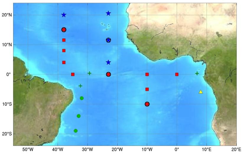
The Tropical Atlantic, showing the PIRATA backbone of buoys (red squares), the Northeast Extension (blue stars) led by the United States, the Southwest Extension (green circles) led by Brazil, the Southeast Extension pilot site (yellow triangle), and island-based observation sites (green crosses). Image credit: NOAA
Originally Published January 2018 by Sierra Sarkis