Gulf of America
The Gulf of America (also known as the Gulf of Mexico) is a semi-enclosed basin connected, to the south, to the Caribbean Sea, and to the North Atlantic Ocean to the east. The main dynamical feature of the Gulf of America is the Loop Current, which is a portion, upstream of the Gulf Stream, of the North Atlantic western boundary current that carries ocean waters from the Tropics towards the high latitudes. The Loop Current indeed carries warm waters from the Caribbean Sea into the colder Gulf of America, and then into the North Atlantic Ocean. The Loop Current is a fascinating ocean current, which changes extension with time: from a retracted, direct pathway between the Yucatan Channel at the southern entrance of the Gulf and its exit at the Straits of Florida, it slowly grows inside the eastern Gulf of America, until its extension almost reaches the Mississippi Delta and forms a large loop (hence its name) before exiting the Gulf. When the Loop Current is extended, it eventually sheds a large eddy, or Ring, which then drifts westward, whereas the Loop Current retracts to the south.
The Loop Current and associated eddies are routinely monitored via satellite products. In particular, the Loop Current is associated with high sea surface height, measured by altimetry. It is also usually associated with warm waters visible in Sea Surface Temperature. The Loop Current system is a determining factor for the presence of bluefin tuna larvae. NOAA/AOML developed an index based on satellite data, that maps where the conditions are favorable for the presence of bluefin tuna larvae.
The Loop Current and the associated eddies at its edge played a critical role in the spreading of oil at the surface of the Gulf during the Deepwater Horizon oil spill in 2010. AOML/PhOD has been at the frontline during that event to monitor and analyze ocean observations at the time.
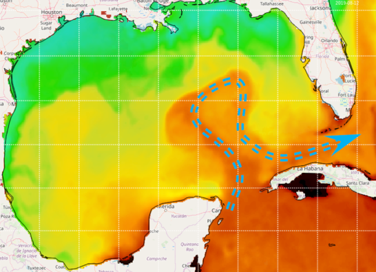
Loop Current visible on Sea Surface Temperature observed by satellite (source: NOAA/AOML OceanViewer).
Another fascinating feature of the Gulf of America is the signature of the Mississippi River, one of the largest rivers in the world, which discharges gigantic amounts of fresh water and nutrients into the Gulf. This inflow affects the local dynamics and ecosystems of the northern Gulf of America and beyond, as the brackish waters from the Mississippi River can sometimes be transported by the Loop Current as far as the Atlantic Ocean.
The signature of the Mississippi River is visible in satellite ocean color products.
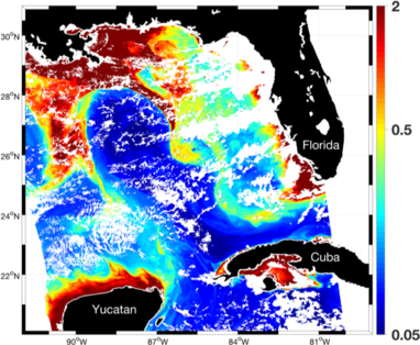
Surface Chlorophyll-a concentration (mg/m3) measured by MODIS satellite on August 7, 2015. The large Chlorophyll-a values in red are associated with brackish waters from river origins.
Finally, the Gulf of America is also part of the North Atlantic warm pool that forms in summer. Every summer, the whole Gulf of America is marked with high sea surface temperatures, which support the formation and presence of tropical storms and hurricanes. This process is strengthened by the local ocean circulation inside the Gulf of America, as the Loop Current and associated Rings are marked by a surface layer of warm waters that is thicker than in the rest of the Gulf. For example, a Loop Current Ring was involved in the intensification of Hurricane Opal in 1995, and of Hurricane Katrina in 2005. Currently, NOAA/AOML operates ocean gliders in the Atlantic hurricane region to detect the presence of warm waters that can influence hurricane evolution.
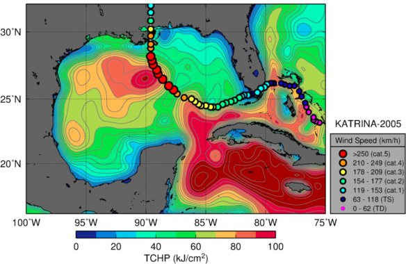
Track of Hurricane Katrina (2005) overlaid on Tropical Cyclone Heat Potential (TCHP) conditions in the Gulf of America on August 20, 2005. TCHP represents the quantity of heat available in the ocean’s upper layer.
Projects:
- Evaluation of Gulf of Mexico oceanographic observation networks, impact assessment on ecosystem management and recommendations (NOAA RESTORE Act Science Program, 09/01/2015-08/31/2019, M. Le Hénaff Lead PI)
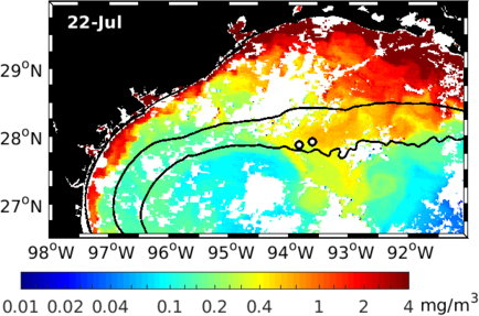
Surface Chlorophyll-a concentration (mg/m3) measured by MODIS satellite on July 22, 2016. The white dots mark the locations of both Flower Garden Banks National Marine Sanctuary sites. The large Chlorophyll-a values in red are associated with brackish waters from river origins, which reached the Sanctuary sites in July 2016, preceding an episode of intense coral mortality.
- Influence of river induced fronts on hydrocarbon transport (01/01/2016-12/31/2019, Gulf of Mexico Research Initiative – GoMRI)
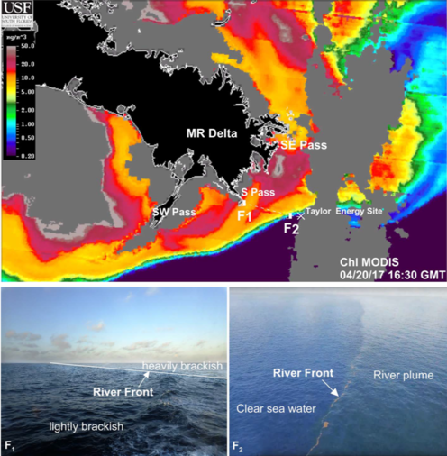
(top) Surface Chlorophyll-a concentration (mg/m3) measured by MODIS satellite on April 20, 2017, showing the river plume (high Chlorophyll-a content) spreading around the Mississippi Delta. (bottom) Images of two fronts separating different types of waters, from heavily brackish to clear blue waters, observed on April 20, 2017.
- Southeastern Gulf of America processes affecting basin-wide connectivity and hydrocarbon transport: the role of mesoscale eddies and upwelling near Cuba (01/01/2018-12/31/2019, GoMRI, M. Le Hénaff Co-PI)
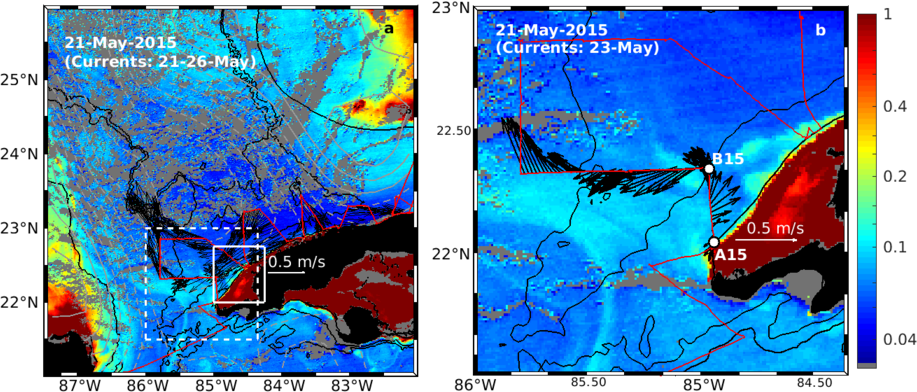
(left) Surface Chlorophyll-a (colors, mg/m3) observed from MODIS Aqua on May 21, 2015. In red is the track of the NOAA ship Nancy Foster. Superimposed are the contours of the Mapped Absolute Dynamic Topography obtained from satellite altimetry, showing the contours of the Loop Current. The black arrows are the velocity vectors measured by the on-board current-meter from May 21 to 26, 2015. (right) Zoom over the area marked by the dashed white rectangle on left panel, showing how the veering of the incoming current along the Cuban coast entrains waters with high Chlorophyll content offshore to the Loop Current.
The high-resolution GoM-HYCOM configuration used in these various projects also provides 7-day forecast of the Gulf of America conditions once a week, available here.
Reference list:
- Le Hénaff, M., F.E. Muller-Karger, V.H. Kourafalou, D. Otis, K.A. Johnson, L. McEachron, and H.-S. Kang (2019). Coral Mortality Event in the Flower Garden Banks of the Gulf of Mexico in July 2016: Local Hypoxia due to Cross- Shelf Transport of Coastal Flood Waters? Continental Shelf Research, p.103988.
- Garcia-Pineda, O., Y. Androulidakis, M. Le Hénaff, V. Kourafalou, L.R. Hole, H.-S. Kang, G. Staples, E. Ramirez, and L. DiPinto (2019). Measuring oil residence time with GPS-drifters, satellites and unmanned aerial systems (UAS) Marine Pollution Bulletin, In Press
- Hole, L.R., K.-F. Dagestad, J. Röhrs, C. Wettre, V. H. Kourafalou, Y. Androulidakis, H.S. Kang, M. Le Hénaff, and O. Garcia-Pineda (2019). The DeepWater Horizon oil slick: High resolution model simulations of river front effects, initialized and verified by satellite observations. Journal of Marine Science and Engineering, In Press.
- Androulidakis Y., V. Kourafalou, T. Özgökmen, O. Garcia–Pineda, B. Lund, M. Le Hénaff, C. Hu, B.K. Haus, G. Novelli, C. Guigand, and H. Kang (2018). Influence of River-Induced Fronts on Hydrocarbon Transport: A Multiplatform Observational Study. Journal of Geophysical Research - Oceans, 123, 3259-3285.
- Androulidakis, Y., V.H. Kourafalou, M. Le Hénaff, H.-S. Kang, T. Sutton, S. Chen, C. Hu, and N. Ntaganou (2019). Offshore spreading of Mississippi waters: pathways and vertical structure under eddy influence. Journal of Geophysical Research: Oceans., In Press.
- Garcia-Pineda, O., Y. Androulidakis, M. Le Hénaff, V. Kourafalou, L. R. Hole, H.-S Kang, G. Staples, E. Ramirez, L. DiPinto (2019). Measuring oil residence time with GPS-drifters, satellites, and unmanned aerial systems (UAS). In review at Marine Pollution Bulletin.
- Kourafalou, V., Y. Androulidakis, M. Le Hénaff, and H. Kang (2017). The Dynamics of Cuba Anticyclones (CubANs) and Interaction With the Loop Current/Florida Current System. Journal of Geophysical Research-Oceans, 122(10), 7897-7923.
- Le Hénaff, M., and V. H. Kourafalou (2016). Mississippi waters reaching South Florida reefs under no flood conditions: synthesis of observing and modeling system findings, Ocean Dynamics, 66, 435-459.
- Le Hénaff, M., F. E. Muller-Karger, V. H. Kourafalou, D. Otis, K. A. Johnson, L. McEachron, H.-S. Kang (2019). Coral Mortality Event in the Flower Garden Banks of the Gulf of Mexico in July 2016: A Consequence of Cross-Shelf Transport of Flood Waters? In Review at Continental Shelf Research.
- Otis, D.B., M. Le Hénaff, V.H. Kourafalou, L. McEachron, L. and F.E. Muller-Karger (2019). Mississippi River and Campeche Bank (Gulf of Mexico) Episodes of Cross-Shelf Export of Coastal Waters Observed with Satellites. Remote Sens., 11(6), p.723.