Skip to Content

Category Archives: Physical Oceanography

Technology and Modeling Innovations Usher in the 2016 Hurricane Season

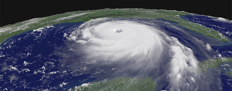
Scientists at NOAA’s Atlantic Oceanographic and Meteorological Laboratory (AOML) are at the vanguard of hurricane research. Each hurricane season we fly into storms, pore over observations and models, and consider new technological developments to enhance NOAA’s observing capacity and improve track and intensity forecasts. The 2016 hurricane season will provide an opportunity for our scientists to test some of the most advanced and innovative technologies and refined forecasting tools to help better predict a storm’s future activity.

0 Continue Reading →

New Study Describes Link Between South Atlantic Ocean and Global Rainfall Variability

In a recent paper published in the Journal of Climate, scientists with NOAA and the University of Miami have identified how variability in ocean circulation in the South Atlantic Ocean may influence global rainfall and climate patterns. The study by researchers at NOAA’s Atlantic Oceanographic and Meteorological Laboratory (AOML) and the Cooperative Institute for Marine and Atmospheric Studies (CIMAS) suggests that the South Atlantic is a potential predictor of global rainfall variability with a lead-time of approximately 20 years. This link between the South Atlantic Ocean and weather and climate could provide significant long-term insight for water management on a global scale.

0 Continue Reading →

AOML Oceanographers Collect Coast to Coast Measurements on the GO-SHIP Indian Ocean Cruise

During the months of March and April, AOML joined an international team of oceanographers to actively sample the Indian Ocean in support of the Global Ocean Ship-Based Hydrographic Investigation Program (GO-SHIP), an initiative to measure and investigate the ocean basins from coast to coast and from top to bottom. Aboard the R/V Roger Revelle, the team transected the Indian Ocean from the Antarctic northward into the Bay of Bengal, collecting seawater samples at 113 stations as part of a multi-decadal effort to measure various ocean properties, including temperature, salinity, nutrients, carbon and other gases.

0 Continue Reading →

New Antenna System Design Improves Reliability and Significantly Reduces Cost

Scientists and engineers from NOAA have successfully designed, built, and tested a new antenna system that dramatically increases data transmission reliability while drastically reducing operating costs. The new Iridium-based transmission system, developed by NOAA’s Atlantic Oceanographic & Meteorological Laboratory (AOML) & the Cooperative Institute for Marine & Atmospheric Studies (CIMAS), has no restrictions on data format or size, allowing data from various ocean and land-based observation platforms to be transmitted more securely and at a fraction of the cost of the older Inmarsat-C platform.

0 Continue Reading →

AOML-led Carbon Dioxide Sampling Effort Helps Quantify the Ocean’s Role in Global Carbon Budget

Researchers with the Global Carbon Budget released their annual update for the global carbon budget in December 2015, revealing carbon dioxide (CO2) emissions from fossil fuels increased slightly in 2014 (+0.6%), but are projected to decline slightly (by est. -0.6%) in 2015. The global oceans serve as a natural buffer, offsetting increased emissions by absorbing an estimated 27% of human-produced CO2 from the atmosphere in 2014. Data collected, in part, from long-term surface ocean CO2 monitoring efforts, funded by NOAA’s Climate Program Office and the Ocean Acidification Program, indicate that the oceans removed about 10.7 billion tons of CO2 from the atmosphere in 2015.

0 Continue Reading →

Long-term AOML Research Project Reaches Important Milestone

On October 15, 2015, the scientists, technicians, and engineers involved in the AOML Western Boundary Time Series (WBTS) project marked a milestone with the completion of the 100th successful dropsonde cruise in the Florida Current since the project’s inception in 2000.

0 Continue Reading →

Behind the 2015 Atlantic Hurricane Season: Wind Shear & Tropical Cyclones

Wind Shear
No Wind Shear

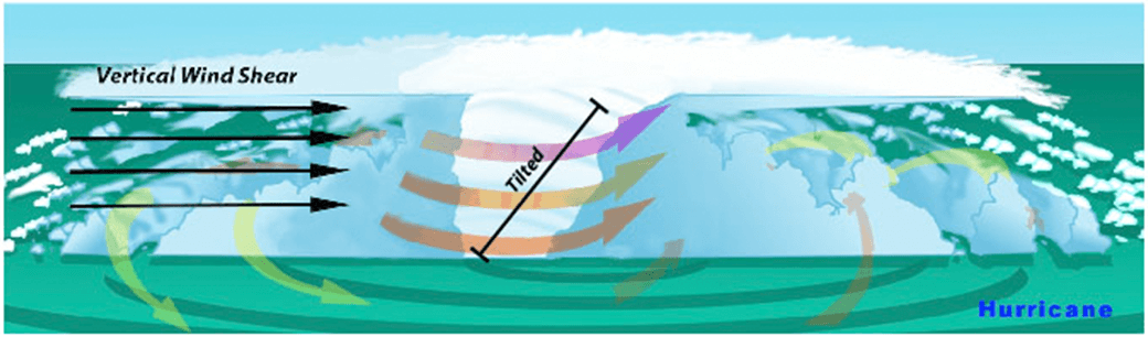
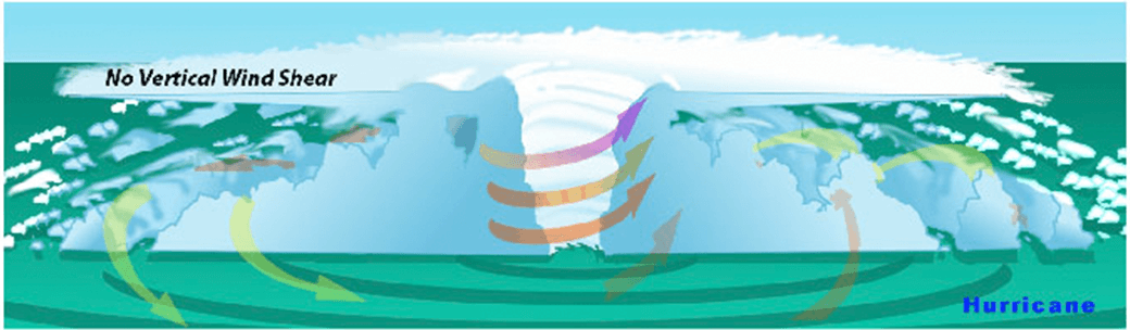
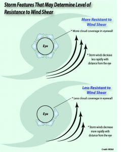
In the presence of vertical wind shear, a storm’s core structure will be tilted in relationship to the wind shear. This tilting will disrupt the flow of heat and moisture which inhibits the storm from developing and becoming stronger.

With the 2015 Atlantic hurricane season underway, researchers are pointing to the strong presence of El Niño as the major driver suppressing the development of tropical cyclones in the Atlantic basin. But what specific conditions are associated with El Niño that lead to a less than ideal environment for tropical cyclone development? Through research and observation, hurricane researchers know strong environmental wind shear is a major factor affecting potential hurricane development and growth. This hurricane season, AOML researchers are delving further into the relationship between wind shear and tropical cyclones.

What is wind shear?

Wind shear is the variation of the wind’s speed or direction over a short distance within the atmosphere. For tropical cyclones, wind shear is important primarily in the vertical direction, as these storms occupy a large vertical slice of the atmosphere from sea level to the top of the troposphere, which extends up to about 40,000 feet altitude in the tropics in summer.

How does wind shear affect tropical cyclone development?

Tropical weather systems are vulnerable to changes in the broader atmosphere surrounding them; often influenced by large features such as areas of high and low pressure, and fronts. If there’s too much wind, these weather systems have trouble organizing and developing into a tropical cyclone. As a tropical system forms, heavy thunderstorms build near the center. Given the right environment, these systems can eventually begin turning counter-clockwise (or cyclonically) in the northern hemisphere. With little to no wind shear, the turning within the tropical system is uniform and the storm becomes vertically aligned, helping to keep it intact and, likely, strengthening.

The most favorable condition for tropical cyclone development is the absence of wind shear. When wind shear is present, however, a storm’s core structure becomes vertically tilted in relationship to the wind shear, disrupting the flow of heat and moisture. Tropical cyclones are heat engines powered by the massive heat release associated with water vapor condensing into liquid water. Vertically-tilted systems are less efficient at drawing in warm and moist air from the surrounding ocean and will be less likely to develop and strengthen.

How does El Niño affect the presence or absence of wind shear?

El Niño is a climate phenomenon driven by above average ocean temperatures in the central and eastern tropical Pacific. While that warmth helps boost Pacific storm activity, the extra heat transferred to the atmosphere leads to a domino effect, altering climate around the globe.

Specifically, the instability over the warm equatorial Pacific during El Niño creates changes in the jet stream over the Northern Hemisphere, resulting in decreased wind shear in the Pacific and increased wind shear across much of the Caribbean and Atlantic. El Niño also increases the atmospheric stability, or resistance of the atmosphere to vertical motion, in the Atlantic basin, which suppresses hurricane activity.

Can a storm persist despite the existence of wind shear?

AOML researchers are focusing on particular characteristics of developed tropical cyclones that enable them to persist despite increased levels of wind shear. The theoretical work focuses mainly on how a tropical cyclone’s wind structure is disrupted by wind shear.

Using a simple mathematical model, researchers can estimate the degree to which the center of the storm becomes vertically tilted based on the cloudiness within the eyewall, as well as the structure of the wind outside the eyewall. By modeling the development of storm tilt, a better understanding of a tropical cyclone’s behavior is gained in the presence and absence of wind shear.

Results suggest that tropical cyclones are more likely to resist disruption by vertical wind shear when clouds cover a large portion of the eyewall and when winds decrease less rapidly from the eye. These model simulations show promise in understanding the fundamental physical processes driving intensity and structural changes of tropical cyclones due to environmental factors.

Model results suggest certain features such as cloudiness within the eyewall as well as the structure of the wind outside the eyewall may determine a storm’s level of resistance to wind shear.

A Doppler wind lidar instrument added to NOAA’s hurricane hunter aircraft this season will assist AOML researchers in collecting observational data to better understand the wind environment around tropical cyclones. The lidar instrument is used to collect, process, and transmit atmospheric data from within a hurricane, enabling NOAA to sample the winds inside the eyewall of storms. By leveraging observational expertise and new data combined with modeling, AOML researchers hope to learn more about the wind environment and the interaction between wind shear and tropical cyclones, allowing them to better predict a hurricane’s future activity and intensity.

Originally Published by Edward Pritchard, AOML

0 Continue Reading →

AOML Joins Ocean Acidification Program Research Cruise Along U.S. East Coast

A team of researchers, including scientists from AOML and the University of Miami, set sail June 19th on a research cruise aboard the NOAA ship Gordon Gunter to provide increased understanding of ocean acidification and its drivers along the U.S. East coast. The cruise, which is part of a larger effort supported by NOAA’s Ocean Acidification Program, investigated near-shore and deep waters, and provided researchers with more detailed information about changing ocean chemistry in different environments.

Ocean acidification is a fundamental change in ocean chemistry involving a progressive decline in pH over decades caused primarily by the absorption of increasing carbon dioxide emissions. Additionally, freshwater and nutrient run off from the coasts can alter seawater chemistry. The rise in dissolved CO2 and concurrent drop in pH (lower pH indicates higher acidity), changes ocean chemistry in a way that robs marine organisms, such as mollusks and corals, of the carbonate ions they need to build shells and skeletons. At the same time, the increasing acidity can erode the structures they’ve already built, and appears capable of disrupting their bodies in other ways that make it hard for them to thrive.

The Gunter traveled north from Newport, RI to survey the waters of the Nova Scotia Shelf and then steamed south, surveying waters close to shore to provide detailed information about water chemistry within the Gulf of Maine, Long Island Sound, the Mid-Atlantic and Southern Bight regions. The ship also investigated central Florida waters before reaching Miami on July 24. Similar Ocean Acidification Program cruises have taken place on the U.S. West Coast and the Gulf of Mexico. Understanding why and how fast ocean chemistry is changing along our coasts will allow scientists to better predict future changes, explore ways to adapt to those shifts, and provide insight into where marine organisms may be at greatest risk along U.S. coasts.

AOML researchers measured inorganic carbon dioxide, partial pressure of carbon dioxide, and collect nutrient samples to be analyzed later at AOML. By collecting and analyzing samples in near-shore and deeper waters, scientists will better understand what drives the process of ocean acidification in different regions of the East Coast. The East Coast has a broad shallow shelf, which could be a significant source of potentially corrosive, freshwater discharge from rivers into the coastal ocean. Sampling along the coast will allow scientists to understand how fresher waters, coastal influences, and phytoplankton may alter our ocean chemistry. This environmental information about ocean acidification is essential to predicting its effects on important marine resources, so that communities can mitigate and adapt to these changes.

0 Continue Reading →

Veteran oceanographer, Dr. Molly Baringer, selected as AOML’s next deputy director

Dr. Molly Baringer, AOML deputy director

AOML is pleased to announce Dr. Molly Baringer as AOML’s next deputy director. Molly officially began her new position on May 18 after serving in an acting capacity since October, 2014.

Molly is a veteran sea-going oceanographer and has led numerous research projects during her 21-year tenure at AOML. Her research portfolio is strongly rooted in the Atlantic Ocean, linking ocean circulation patterns and changes to global and regional climate patterns. She skillfully manages research teams and projects, and forges partnerships with national and international research institutions, including the National Science Foundation, NASA, and the National Environmental Research Council in the UK, among others, to bring AOML science to bear.

Molly’s research expertise includes measuring the strength of the Western Boundary Current in the North Atlantic, monitoring the meridional overturning circulation in the North Atlantic as part of the RAPID/MOCH program, managing high-density XBT observations in the Atlantic, and leading repeat hydrography and coastal carbon dioxide surveys. Molly has served in leadership roles on more than 29 hydrographic programs since 1998, including the role of chief scientist on more than a dozen of these cruises.

Molly’s scientific leadership extends well beyond the ship’s helm. Molly has served on more than 21 national and international panels including as secretary of the Physical Oceanography Section of the American Meteorological Society and the International Argo Panel, regularly providing advice and direction on national science policy and program management, including stakeholder negotiations.


Molly received her doctoral degree in 1994 from the Massachusetts Institute of Technology and Woods Hole Oceanographic Institution in the field of physical oceanography. Molly is also a graduate of NOAA’s Leadership Competency Development Program and the National Weather Service’s Building Leaders for a Solid Tomorrow (BLAST) program. Molly also served as AOML’s acting deputy director in 2010, during the Deep Water Horizon oil spill, skillfully managing resources to support AOML’s scientific response.

Molly has published over 77 peer-reviewed publications in journals such as Science, the Journal of Climate, and the Journal of Geophysical Research, to name a few. Over the past ten years she has also served as a principal investigator or co-principal investigator on numerous externally funded research programs totalling more than $30 million. She is also the recipient of the Department of Commerce Bronze Medal award for her role on the Western Boundary Time Series Team.

As deputy director of AOML, Molly works very closely with AOML’s director, Dr. Robert Atlas, and supervises the administrative, facilities and security, computer network, and communications staff within the Office of the Director. Molly will also continue her scientific leadership roles for the Western Boundary Times Series and Argo projects.

0 Continue Reading →

Indian Ocean Plays Key Role in Global Warming Hiatus

The earth is warming, but temperatures in the atmosphere and at the sea surface that steadily rose in the last half-century have leveled off and slowed in the past decade, causing the appearance of an imbalance in Earth’s heat budget. Scientists are looking into the deep ocean to determine where this additional heat energy could be stored, and recently traced a pathway that leads to the Indian Ocean.

In a study published May 18 in Nature Geoscience, oceanographers from the University of Miami’s Rosenstiel School, Cooperative Institute for Marine and Atmospheric Studies (UM/CIMAS), NOAA and their colleagues identified a key mechanism that explains the apparent contradictions associated with the recent global warming hiatus. Building upon previous studies that suggest enhanced heat uptake in the tropical Pacific Ocean as the major source of the imbalance, the new study tracked this excess heat from the Pacific to the Indian Ocean via Indonesian pathways.

Since the 1950s, global average surface air temperatures have increased steadily, with the warming attributed to greenhouse gases originating from human activities. Since the start of the 21st century however, global surface warming has almost stalled. This contradicts with the amount of net radiation entering Earth at the top of the atmosphere, which continues to suggest an increasingly warming planet. The slowdown of surface warming was the focus of a series of studies that sought to identify and track the causes of this process.

Researchers initially pegged the tropical Pacific as the major source of heat uptake, theorizing that the basin was storing a large portion of the global heat imbalance over the last decade, thereby causing the atmosphere to warm less. Natural climate variability processes such as El Niño/Southern Oscillation (ENSO), a cycle of warm and cold sea surface temperature in the tropical Pacific Ocean, drive wind patterns and ocean currents across the region. Since the turn of the century, the cold phase of ENSO, known as La Niña, has persisted, increasing the uptake of warm surface waters in the subtropics. This process and others have enhanced the uptake of heat from the atmosphere to the top 2,000 ~ 3,000 feet of the ocean.

While uptake in the Pacific as a result of La Niña-like conditions may have answered the initial question regarding the heat missing from the atmosphere, findings from the recent study indicate that Pacific heat has been slowly decreasing and that the excess heat has been transported elsewhere.

“When I first saw from the data that Pacific heat was going down, I was very curious and puzzled,” says the study’s lead author Dr. Sang-Ki Lee, a climate researcher with UM/CIMAS and NOAA’s Atlantic Oceanographic and Meteorological Laboratory.

Results from the study suggest that the excess heat is being stored in the Indian Ocean, which has seen an unprecedented rise in heat over the past decade. Researchers studied observations going back to 1950 and noticed that the Indian Ocean heat uptake stayed relatively low until 2003 or so. From that point forward, observations indicated that heat began to build in the Indian Ocean and there was no evidence to support that the source was from the atmosphere. By running simulations from a global ocean-sea ice model to track the pathway of heat, researchers found that the heat originally stored in the Pacific was transported by a strong ocean current, known as the Indonesian Throughflow, and ended up in the Indian Ocean. The heat flux into the Indian Ocean via the Indonesian pathway means that the Indian Ocean is increasingly important in modulating global climate variability and is now home to 70 percent of all heat taken up by global oceans during the past decade.

The study helps resolve an important debate regarding the warming hiatus. Scientists theorize the Pacific played a role in the warming hiatus, yet all observations indicated that total heat in the Pacific basin had not increased as expected. This study reveals that the Pacific was an intermediary in the heat storage process, but not the final destination, explaining the lack of change in Pacific heat.

Lee has several thoughts about future effects of this warm deep ocean water. In its current location, Lee said it’s possible that the warm water in the Indian Ocean could affect the Indian Monsoon, one of the most important climate patterns in the world that affects more than 1 billion people. What it means for future El Niño cycles is not immediately clear. However, Lee noted that the warm water in the western Pacific, which provides the energy needed to produce intense El Niño events, has been partially discharged into the Indian Ocean, suggesting weaker El Niño events in the near future.  Lee also indicates that the heat content is likely to continue moving with global ocean currents and may find its way into the Atlantic basin in the coming decades.

“If this warm blob of water in upper Indian Ocean is transported all the way to North Atlantic, that could affect the melting of Arctic sea ice,” Lee said. “That can also increase hurricane activity and influence the effects of drought in the U.S, but future studies are required to validate these hypotheses.”


Originally Published in May 2015 by Edward Pritchard

0 Continue Reading →