For the latest forecasts and critical weather information, visit www.weather.gov/.
Hurricane DynamicsHurricanes are nearly circular, warm-core vortices, characteristically 1000 km in radius. Strong winds and precipitation are concentrated near, but not at, their centers. Coincident with strongest winds, convective updrafts, fed by inward spiraling surface winds, release latent heat drawn from the ocean to power the storm. The clear eye, 15-30 km in radius, contains the axis of vortex rotation and is surrounded by this ring of strong winds. The eye is characterized by the warmest temperatures in the vortex, low humidity, low pressure, in extreme cases > 10% below that in the undisturbed tropical atmosphere, and calm winds at the very center. The hurricane's eye presents one of the truly magnificent vistas offered to human sight, and the hurricane's workings delight the mind as an intricate and subtle problem in hydrodynamics. A typical radar image A cross section In the center of the hurricane is the cloud-free eye. The clouds that enclose the eye form the eyewall. These clouds draw air from the eye at low levels, causing descent, drying, and warming inside the eye. As the air warms, it becomes less dense so surface pressure must fall. The clouds also draw air inward from outside the eye, thus concentrating the counter-clockwise rotation and increasing the swirling winds. In a hurricane, the strongest winds are near the surface and just outside the eyewall. An unanticipated use of the new GPS sondes was direct observation of low-level wind jets at the inner edge of the eyewall.
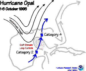
A typical hurricane intensifies slowly, remaining in Category 1 or reaching 2 or even 3 before it runs ashore or drifts north out of the tropics. The strongest hurricanes, such as Andrew in 1992, intensify rapidly and go from Category 1 or 2 to Category 4 or 5 in just a day or two. The process that initiates rapid intensification may begin with atmospheric waves that form on the hurricane vortex at altitudes of greater than 12 kilometers (where the new jet will fly). These waves result from interaction with nearby low-pressure systems. The waves, through a complicated chain of cause and effect, intensify the cumulus clouds that are involved in the energy conversion mechanisms of a hurricane. Shear of the environmental wind appears to be the mechanism by
which atmospheric teleconnections modulate Atlantic hurricane
activity and is generally thought to have a significant role in
day-to-day intensity changes of individual storms. Airborne Doppler
and reflectivity radar data collected during AOML research flights
into Hurricane Olivia
show that an environmental shear > 10 m s-1 imposes
a wavenumber-one structure on the eyewall convection. Individual
cells form ~45 to the right of the down-shear direction, reach
maturity with reflectivities > 45 dBZ on the left side of the
shear vector, and have largely rained out by the time they detach
from the eyewall as they advect back to the right side of the
shear. AOML research has produced accurate, timely maps of surface winds in hurricanes. These maps, which are based upon aircraft observations, are invaluable for preparation of forecasts before landfall and for damage assessment after landfall. The maps are now prepared routinely whenever a hurricane threatens land. A particularly important application of these products is the rapid identification of the most severely devastated areas; this enables disaster response teams to reach them quickly. The same techniques are now being applied for reconstruction of historical storms. |
Links of Interest
AOML Tools & Resources
Employee Tools
Stay Connected
|