The Hurricane Forecast Improvement Project era
In particular, Hurricane Katrina's devastation spurred greater funding for RI studies and the inauguration of the Hurricane Forecast Improvement Project (HFIP) which HRD has helped to manage. This meant a new era emphasizing efforts to ingest inner-core data from hurricanes into the new-generation of hurricane models that empahsize intensity forecasting.
 One such project is the Tail-Doppler Radar experiment, carried out from 2009 to the present. This involves processing data from the P-3's Tail Doppler radar onboard the aircraft, then transmitting them in real-time via satellite to ground sations. This data is ingested into operational forecast models in an effort to improve the intensity forecasts. One such project is the Tail-Doppler Radar experiment, carried out from 2009 to the present. This involves processing data from the P-3's Tail Doppler radar onboard the aircraft, then transmitting them in real-time via satellite to ground sations. This data is ingested into operational forecast models in an effort to improve the intensity forecasts.
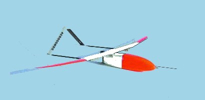 The 2005 hurricane season also saw an Aerosonde unmanned airborne vehicle (UAV) fly into Tropical Storm Ophelia. This was the result of several years effort attempting to place a UAV into the critical (but dangerous) boundary layer in a tropical cyclone. In 2007, another Aerosonde was flown into hurricane-force winds for the first time in Tropical Storm Noel off of the Carolinas. The 2005 hurricane season also saw an Aerosonde unmanned airborne vehicle (UAV) fly into Tropical Storm Ophelia. This was the result of several years effort attempting to place a UAV into the critical (but dangerous) boundary layer in a tropical cyclone. In 2007, another Aerosonde was flown into hurricane-force winds for the first time in Tropical Storm Noel off of the Carolinas.
Unfortunately, troubles with air corrider access limited further work with the shore-launched Aerosondes. However, HRD began cooperating with the development of the P-3 launched COYOTE UAV. This resulted in successful deployement with COYOTEs in Hurricane Edouard in 2014 and in Hurricane Maria in 2017.
HRD will continue in the 21st Century as NOAA's focus for hurricane research, with extensive co-operation with NHC, AOC, USAF, USN, other government agencies, the academic community, and with the private sector. Improvements in computer forecasts are expected to come with further work, as is improved knowledge of hurricane climatology in a changing world.
References...
|
