|
Why are we doing this?
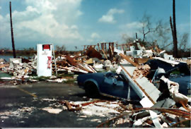 The U.S. is more vulnerable to hurricanes now than at any time in
recent decades. Over the last 30 years coastal population growth
in the U.S. has increased 4-5% y-1. With only a 1-2% y-1 rate
of improvement in official track forecasts, the mean 24-h track
error over the last 10 years is 91 nm (170 km). However, 5% of
the 24-h track errors over the last 10 years are >200 nm (370
km). To minimize the possibility that a coastal area may be struck
without time to prepare, much larger areas are warned than will
actually experience damaging winds. While specific track models
have indicated up to 15-30% improvement over the past 2-3 years,
the average length of coastline warned, 400 nm (730 km), roughly
a 4/1 ratio to the track error, has not decreased over the past
decade. In fact, it has increased over the 30-year mean of 300
nm (556 km) in response to the emergency manger's desire for longer
lead-times (PDT-5,
1998 PDF or HTML).
The U.S. is more vulnerable to hurricanes now than at any time in
recent decades. Over the last 30 years coastal population growth
in the U.S. has increased 4-5% y-1. With only a 1-2% y-1 rate
of improvement in official track forecasts, the mean 24-h track
error over the last 10 years is 91 nm (170 km). However, 5% of
the 24-h track errors over the last 10 years are >200 nm (370
km). To minimize the possibility that a coastal area may be struck
without time to prepare, much larger areas are warned than will
actually experience damaging winds. While specific track models
have indicated up to 15-30% improvement over the past 2-3 years,
the average length of coastline warned, 400 nm (730 km), roughly
a 4/1 ratio to the track error, has not decreased over the past
decade. In fact, it has increased over the 30-year mean of 300
nm (556 km) in response to the emergency manger's desire for longer
lead-times (PDT-5,
1998 PDF or HTML).
For over 40 years NOAA's hurricane research field program collected data required to support analytical and theoretical hurricane studies. These studies are designed to improve the understanding of the structure and behavior of hurricanes. Over the 25 years that the NOAA WP-3D research aircraft have been active, HRD has collected observations in over 80 tropical cyclones. These data sets have enabled the development of new theories, analysis tools and dramatic forecast improvements, e.g.,
While the data sets collected over the past 20 years have improved track forecasts and our description of mature storm structure, the main purpose for the experiments proposed for 2002 is to improve methods for hurricane prediction, in particular forecasts of storm intensity. |
Links of Interest
AOML Tools & Resources
Employee Tools
Stay Connected
|

| ||