Atlantic Oceanographic & Meteorological Laboratory Global Carbon Cycle
« GCC Home
R/V Brown Data:

» Introduction
» CruiseTracks
» Realtime Display
» Cruise Inventory
» Annual Files
» Contact
» Internal QC Plots » Ron Brown Homepage
» Ron Brown Schedule Page

Ongoing R/V Brown Data » 1998 Data

For all this year's data click on the Annual Files link on the left

A map showing the cruise track of the 24 North cruise.  Leg 1 goes from Miami, FL to Las Palmas, Canary Islands and Leg 2 goes from Las Palmas, Canary Islands to Miami, FL, along the 24 North latitude line.

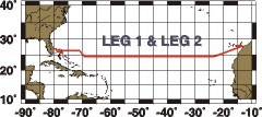
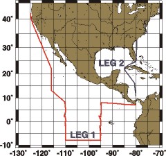
24 NORTH: Leg 1-2
1/8-2/24/1998
» Leg 1 CSV Data File
» Leg 1 Readme File
» Leg 2 CSV Data File
» Leg 2 Readme File
DIC:
» Leg 1 Readme File
» Leg 2 Readme File

A map showing the track of the Gasex 1998 cruise.  Leg 1 goes from Miami, FL to Lisbon, Portugal.  Leg 2 leaves from Lisbon, Portugal and proceeds to a warm core eddy field centered near 46 N, 21 W where the ship remained for 26 days before proceeding to Punta Del Gado, Azores.  Leg 3 goes from Punta Del Gado, Azores to Miami, FL. GASEX: Leg 1-3
5/7-7/7/1998
» Leg 1 CSV Data File
» Leg 1 Readme File
» Leg 2 CSV Data File
» Leg 2 Readme File
» Leg 3 CSV Data File
» Leg 3 Readme File
DIC:
» Leg 1 CSV UW Data File
» Leg 1 Readme File
» Leg 2 CSV UW Data File
» Leg 2 Readme File
» Leg 3 CSV UW Data File
» Leg 3 CSV Bottle Data File
» Leg 3 Readme File
A map showing the transit of the Ronald H. Brown from the Atlantic to the Pacific.  Leg 1 goes from Miami, FL to the Panama Canal.  Leg 2 goes from the Panama Canal to Newport, OR. TRANSIT: Leg 1-2
7/11-7/28/1998
» Leg 1 CSV Data File
» Leg 1 Readme File
» Leg 2 CSV Data File
» Leg 2 Readme File
DIC:
» CSV UW Data File
» Readme File
A map showing the track of the VENTS 1998 cruise.  Leg 1 goes from Newport, OR to an area bounded by 44.5 N, 45.5 N, 129.5 W and 130.5 W before going to Victoria, B.C.  Leg 3 goes from Newport, OR to an area near 46 N, 130 W where the ship remained for 23 days before going to Victoria, B.C.  Leg 4 follows a triangular course from Victoria, B.C. to 46 N, 130 W, to 50 N, 145 W and then back to Seattle, WA. VENTS: Leg 1,3,4
7/30-10/3/1998
» Leg 1 CSV Data File
» Leg 1 Readme File
» Leg 3 CSV Data File
» Leg 3 Readme File
» Leg 4 CSV Data File
» Leg 4 Readme File   
DIC:
» Leg 1 CSV UW Data File
» Leg 1 Readme File
» Leg 3 CSV UW Data File
» Leg 3 Readme File
» Leg 4 CSV UW Data File
» Leg 4 Readme File
A map showing the track of the TOGA/TAO 1998 cruise.  Leg 1 goes from Seattle, WA to 8 N, 110 W where it follows the 110 W line south to 8 S. It then goes east along the 8 S line to 95 W and turns north, following the 95 W line to 8 N.  From there it proceeds to the Panama Canal.  Leg 2 is a transit leg that goes from the Panama Canal to Charleston, S.C. TAO: Leg 1-2
10/9-11/22/1998
» Leg 1 CSV Data File
» Leg 1 Readme File
» Leg 2 CSV Data File
» Leg 2 Readme File
DIC:
» Leg 1 CSV UW Data File
» Leg 1 CSV Bottle Data File
» Leg 1 Readme File

Department Logos
US Department of Commerce Logo Office of Oceanic and Atmospheric Research Logo Atlantic Oceanographic and Meteorological Laboratory Logo National Oceanic and Atmospheric Administration Logo US Department of Commerce National Oceanic and Atmospheric Administration Office of Oceanic and Atmospheric Research Atlantic Oceanographic and Meteorological Laboratory