Skip to Content

Blog Archives

HWRF Model Leads the Pack in Performance for 2017 Atlantic Hurricane Season

Over the past 20 years, improvements in hurricane computer modeling, observational instrumentation, and forecaster training have greatly increased forecast accuracy. The many complex interactions that occur within the atmosphere remain to be fully understood, especially at the small scales associated with tropical cyclones. However, these milestones mark critical advances in numerical weather prediction that are paving the way to the next generation of NOAA models. While hurricanes cannot be controlled, vulnerability to these complex storms can be reduced through preparedness. Early warning and improved accuracy of forecasts can help save lives and reduce property damages caused by hurricanes.

0 Continue Reading →

New and Improved Tools Aim to Enhance Hurricane Forecast Capabilities

AOML is currently in the midst of a multi-year effort called the Intensity Forecasting Experiment (IFEX). IFEX aims to improve the understanding and prediction of intensity change by collecting observations from all stages of a tropical cyclone life cycle—genesis to decay—to enhance current observational models. By building on years of observational expertise and cutting-edge approaches to data integration and model development, hurricane scientists at AOML lead advancements in observations and modeling that have improved intensity forecasts by 20% in recent years.

0 Continue Reading →

Capturing the Genesis of a Hurricane

NOAA Hurricane Hunters are flying back-to-back missions to study the newly developed Tropical Storm Hermine in the Gulf of Mexico, capturing its evolution from a cluster of thunderstorms into a tropical storm. Getting data during such transitions can help improve hurricane models which currently don’t predict transitions well. Our understanding of the physical processes of early storm development remains limited, largely because there are few observations. 

0 Continue Reading →

From the Eye of the Hurricane to High-Resolution Models – How NOAA Improves Hurricane Forecasts

As a hurricane approaches landfall, citizens are hoping that they are adequately prepared for the potential damage from strong winds and rising oceans. NOAA’s job is to forecast the storm location and strength, or intensity, to help communities make the best informed decisions. For many scientists, predicting intensity is a challenge at the forefront of hurricane research, and in recent years advancements in observations and modeling have improved NOAA’s forecasts of intensity by 20%. We are now at the point where scientists can observe and predict with very fine detail what is happening in the inner core of the storm.

0 Continue Reading →

10th Anniversary of Hurricane Katrina

Early on the morning of August 29th, 2005, Hurricane Katrina made landfall on the Louisiana delta region and the Mississippi coast.  The storm surge brought enormous damage to the Gulf Coast and, when the levees around New Orleans failed, a great number of fatalities.  Coming amidst the very busy 2005 hurricane season, Katrina brought death and destruction not seen in a U.S. land-falling hurricane in decades.

0 Continue Reading →

Behind the 2015 Atlantic Hurricane Season: Wind Shear & Tropical Cyclones

Wind Shear
No Wind Shear

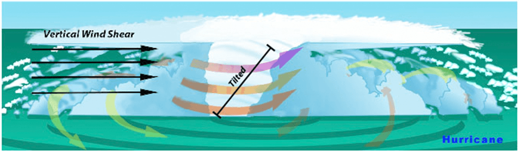
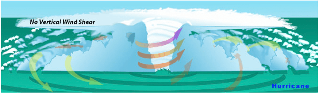
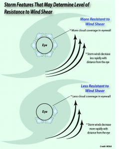
In the presence of vertical wind shear, a storm’s core structure will be tilted in relationship to the wind shear. This tilting will disrupt the flow of heat and moisture which inhibits the storm from developing and becoming stronger.

With the 2015 Atlantic hurricane season underway, researchers are pointing to the strong presence of El Niño as the major driver suppressing the development of tropical cyclones in the Atlantic basin. But what specific conditions are associated with El Niño that lead to a less than ideal environment for tropical cyclone development? Through research and observation, hurricane researchers know strong environmental wind shear is a major factor affecting potential hurricane development and growth. This hurricane season, AOML researchers are delving further into the relationship between wind shear and tropical cyclones.

What is wind shear?

Wind shear is the variation of the wind’s speed or direction over a short distance within the atmosphere. For tropical cyclones, wind shear is important primarily in the vertical direction, as these storms occupy a large vertical slice of the atmosphere from sea level to the top of the troposphere, which extends up to about 40,000 feet altitude in the tropics in summer.

How does wind shear affect tropical cyclone development?

Tropical weather systems are vulnerable to changes in the broader atmosphere surrounding them; often influenced by large features such as areas of high and low pressure, and fronts. If there’s too much wind, these weather systems have trouble organizing and developing into a tropical cyclone. As a tropical system forms, heavy thunderstorms build near the center. Given the right environment, these systems can eventually begin turning counter-clockwise (or cyclonically) in the northern hemisphere. With little to no wind shear, the turning within the tropical system is uniform and the storm becomes vertically aligned, helping to keep it intact and, likely, strengthening.

The most favorable condition for tropical cyclone development is the absence of wind shear. When wind shear is present, however, a storm’s core structure becomes vertically tilted in relationship to the wind shear, disrupting the flow of heat and moisture. Tropical cyclones are heat engines powered by the massive heat release associated with water vapor condensing into liquid water. Vertically-tilted systems are less efficient at drawing in warm and moist air from the surrounding ocean and will be less likely to develop and strengthen.

How does El Niño affect the presence or absence of wind shear?

El Niño is a climate phenomenon driven by above average ocean temperatures in the central and eastern tropical Pacific. While that warmth helps boost Pacific storm activity, the extra heat transferred to the atmosphere leads to a domino effect, altering climate around the globe.

Specifically, the instability over the warm equatorial Pacific during El Niño creates changes in the jet stream over the Northern Hemisphere, resulting in decreased wind shear in the Pacific and increased wind shear across much of the Caribbean and Atlantic. El Niño also increases the atmospheric stability, or resistance of the atmosphere to vertical motion, in the Atlantic basin, which suppresses hurricane activity.

Can a storm persist despite the existence of wind shear?

AOML researchers are focusing on particular characteristics of developed tropical cyclones that enable them to persist despite increased levels of wind shear. The theoretical work focuses mainly on how a tropical cyclone’s wind structure is disrupted by wind shear.

Using a simple mathematical model, researchers can estimate the degree to which the center of the storm becomes vertically tilted based on the cloudiness within the eyewall, as well as the structure of the wind outside the eyewall. By modeling the development of storm tilt, a better understanding of a tropical cyclone’s behavior is gained in the presence and absence of wind shear.

Results suggest that tropical cyclones are more likely to resist disruption by vertical wind shear when clouds cover a large portion of the eyewall and when winds decrease less rapidly from the eye. These model simulations show promise in understanding the fundamental physical processes driving intensity and structural changes of tropical cyclones due to environmental factors.

Model results suggest certain features such as cloudiness within the eyewall as well as the structure of the wind outside the eyewall may determine a storm’s level of resistance to wind shear.

A Doppler wind lidar instrument added to NOAA’s hurricane hunter aircraft this season will assist AOML researchers in collecting observational data to better understand the wind environment around tropical cyclones. The lidar instrument is used to collect, process, and transmit atmospheric data from within a hurricane, enabling NOAA to sample the winds inside the eyewall of storms. By leveraging observational expertise and new data combined with modeling, AOML researchers hope to learn more about the wind environment and the interaction between wind shear and tropical cyclones, allowing them to better predict a hurricane’s future activity and intensity.

Originally Published by Edward Pritchard, AOML

0 Continue Reading →

Hurricane Danny & Tropical Storm Erika Provide Wealth of Research Opportunities for the 2015 Hurricane Field Program

AOML’s hurricane researchers conducted a number of field activities in August that provided data and critical insights into two Atlantic tropical cyclones, Danny and Erika. The two storms enabled researchers to test new instruments in support of the 2015 Hurricane Field Program and conduct research that will benefit future forecasts. Among the highlights were more than 15 successful manned and unmanned aircraft missions into Danny and Erika to collect and provide real-time data to the National Hurricane Center (NHC), as well as evaluate forecast models.

A geo-referenced radar image taken during Hurricane Danny with the P-3’s lower-fuselage radar on Friday, August 21, 2015. Image credit: NOAA

NOAA flew five P-3 aircraft missions and two G-IV jet missions into Hurricane Danny, the first major hurricane of the 2015 season. For Tropical Storm Erika, NOAA flew five P-3 missions and three G-IV missions as the storm impacted the Caribbean. The P-3 missions into Danny marked the first real-time transmission of geo-referenced imagery from the P-3’s lower-fuselage radar to NHC forecasters. This imagery provided valuable information about the structure of Danny as the storm churned in the Atlantic far from land.

The P-3 flights also measured the wind structure of Danny and Erika and the wind shear environment surrounding them. Using the Tail Doppler Radar aboard the P-3, researchers documented high levels of wind shear across the Caribbean, the product of a strong El Nino and a major factor contributing to the dissipation of both storms.

During missions into Danny and Erika, scientists gathered observations for the first time with a Doppler wind lidar instrument mounted on the side of the P-3 fuselage that measures wind velocity in regions without rain. The lidar data will be processed and evaluated for possible inclusion in the HWRF research model to improve wind speed estimates in model guidance.

NOAA’s P-3 aircraft flew multiple missions into Hurricane Danny & Tropical Storm Erika. Image credit: NOAA

NASA’s Global Hawk unmanned aircraft completed the first two flights of its 2015 NOAA campaign when it flew above Tropical Storm Erika on August 26th and 29th. The Global Hawk used onboard instruments to profile the inner workings of Erika and released dropsondes to collect temperature, moisture, wind speed, and wind direction data. The real-time data were transmitted for the first time and incorporated into operational forecast models.

Other instruments aboard the Global Hawk, such as the microwave sounder from NASA’s Jet Propulsion Laboratory, gathered vertical profiles of temperature and humidity and was able to provide a unique view of Erika’s interaction with the Saharan Air Layer, a mass of dry air that inhibited Erika’s growth.

The Global Hawk, managed by NASA’s Armstrong Flight Research Center in California, provided a unique vantage point of Erika at 60,000 feet altitude, flying about 15,000 feet higher than NOAA’s G-IV jet. Both of its flights were 24 hours in length, nearly three times as long as that of the manned aircraft. The Global Hawk is part of NOAA’s Sensing Hazards with Operational Unmanned Technology (SHOUT) project, which seeks to improve hurricane forecasts of track and intensity using data collected by the unmanned aircraft from high in the stratosphere down to the ocean’s surface.

Below the ocean’s surface, another type of unmanned vehicle was in place, collecting data on Erika’s interaction with the upper level of the ocean as the storm passed through the Caribbean. AOML’s two underwater gliders traversed the waters off Puerto Rico, gathering temperature measurements that are critical to understanding the ocean’s role in how storms form, evolve, and change in intensity. These data should also provide researchers with a better understanding of the ocean’s response to the passage of storms which, in turn, will improve ocean models used in hurricane forecasts.


Data collected by NOAA’s hurricane hunter aircraft and the Global Hawk were uploaded in real-time to the Global Telecommunications System for inclusion in environmental models, better enabling researchers to predict the future activity and intensity of Danny and Erika.

0 Continue Reading →

Hurricane Researchers Achieve Important Milestones Despite Quiet 2013 Season

The 2013 Atlantic hurricane season, which officially ended on November 30th, will be noted in the record books as having been a relatively quiet year with the fewest hurricanes since 1982. In fact, it will be ranked as the sixth least-active Atlantic hurricane season since 1950.

Despite this, the 2013 season was quite an active year for scientists with AOML’s Hurricane Research Division (HRD). Flying aboard NOAA’s hurricane hunter aircraft, they conducted missions into Tropical Storms Gabrielle and Karen, as well as Hurricane Ingrid, to gather data for research and assimilation into numerical models.

These data were collected as part of HRD’s annual Hurricane Field Program, a large component of which is the Intensity Forecasting Experiment (IFEX). A goal of IFEX is to better understand the physical processes and other factors that enable tropical cyclones to change intensity, as well as improve tropical cyclone intensity forecasts.

As part of their efforts to gather data for research, HRD scientists released 136 airborne expendable bathythermographs and 367 dropwindsondes from NOAA’s P3 and Gulfstream-IV (GIV) aircraft. These instruments enabled them to obtain information about important features in the atmosphere and ocean. The G-IV jet gathered data during nine flights and the two P3 aircraft conducted 17 missions, for a total of 150 flight hours spent sampling these three tropical systems. Many of the flights were coordinated with NASA’s Hurricane Severe Storm Sentinel missions, which featured two high-altitude, unmanned, Global Hawk aircraft.

One of the highlights of the season was that, for the first time, the P3’s tail Doppler radar data were transmitted directly to NOAA Central Operations and successfully assimilated into the operational HWRF model. This was a significant accomplishment for NOAA that enabled the P3’s Doppler radar data to be included in the latest high-resolution models as part of the effort to continually improve intensity and track forecasts. The tail Doppler radar data provided vital information about the direction and strength of the winds found in Gabrielle, Ingrid, and Karen.

On the modeling and data assimilation fronts, a new basin-wide version of the Hurricane Weather and Research Forecast (HWRF) model developed at HRD was run in real-time during the season, allowing for multiple storms to be forecast concurrently for the first time.  Additionally, HRD provided near-real-time runs of a research version of HWRF initialized with the Hurricane Ensemble Data Assimilation System (HEDAS), a testbed for improving the assimilation of data into the operational HWRF model.

For the first time, high-resolution cloud-motion vectors, as well as other satellite retrievals, were ingested with HEDAS. The model forecasts showed that the assimilation of these data with a sophisticated data assimilation system could provide better forecasts of track and intensity than the current operational system.  HRD’s HWind group successfully made 33 surface-wind analyses for six storms that formed in the Atlantic basin this year.

HRD scientists are thankful for the successes and major milestones achieved during the 2013 Atlantic season, all without having a single hurricane make landfall in the U.S. and with only minimal loss of life and property to the public due to tropical systems.

0 Continue Reading →