Skip to Content

Blog Archives

Hurricane Danny & Tropical Storm Erika Provide Wealth of Research Opportunities for the 2015 Hurricane Field Program

AOML’s hurricane researchers conducted a number of field activities in August that provided data and critical insights into two Atlantic tropical cyclones, Danny and Erika. The two storms enabled researchers to test new instruments in support of the 2015 Hurricane Field Program and conduct research that will benefit future forecasts. Among the highlights were more than 15 successful manned and unmanned aircraft missions into Danny and Erika to collect and provide real-time data to the National Hurricane Center (NHC), as well as evaluate forecast models.
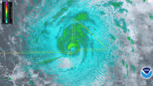
A geo-referenced radar image taken during Hurricane Danny with the P-3’s lower-fuselage radar on Friday, August 21, 2015. Image credit: NOAA

NOAA flew five P-3 aircraft missions and two G-IV jet missions into Hurricane Danny, the first major hurricane of the 2015 season. For Tropical Storm Erika, NOAA flew five P-3 missions and three G-IV missions as the storm impacted the Caribbean. The P-3 missions into Danny marked the first real-time transmission of geo-referenced imagery from the P-3’s lower-fuselage radar to NHC forecasters. This imagery provided valuable information about the structure of Danny as the storm churned in the Atlantic far from land.

The P-3 flights also measured the wind structure of Danny and Erika and the wind shear environment surrounding them. Using the Tail Doppler Radar aboard the P-3, researchers documented high levels of wind shear across the Caribbean, the product of a strong El Nino and a major factor contributing to the dissipation of both storms.

During missions into Danny and Erika, scientists gathered observations for the first time with a Doppler wind lidar instrument mounted on the side of the P-3 fuselage that measures wind velocity in regions without rain. The lidar data will be processed and evaluated for possible inclusion in the HWRF research model to improve wind speed estimates in model guidance.

NOAA’s P-3 aircraft flew multiple missions into Hurricane Danny & Tropical Storm Erika. Image credit: NOAA

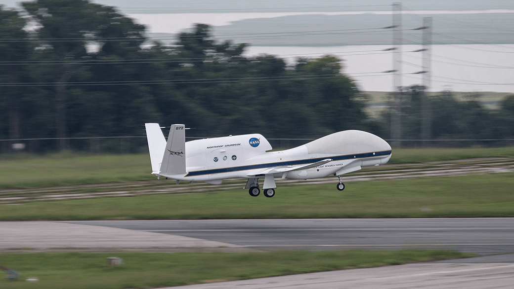
NASA’s Global Hawk unmanned aircraft completed the first two flights of its 2015 NOAA campaign when it flew above Tropical Storm Erika on August 26th and 29th. The Global Hawk used onboard instruments to profile the inner workings of Erika and released dropsondes to collect temperature, moisture, wind speed, and wind direction data. The real-time data were transmitted for the first time and incorporated into operational forecast models.

Other instruments aboard the Global Hawk, such as the microwave sounder from NASA’s Jet Propulsion Laboratory, gathered vertical profiles of temperature and humidity and was able to provide a unique view of Erika’s interaction with the Saharan Air Layer, a mass of dry air that inhibited Erika’s growth.

The Global Hawk, managed by NASA’s Armstrong Flight Research Center in California, provided a unique vantage point of Erika at 60,000 feet altitude, flying about 15,000 feet higher than NOAA’s G-IV jet. Both of its flights were 24 hours in length, nearly three times as long as that of the manned aircraft. The Global Hawk is part of NOAA’s Sensing Hazards with Operational Unmanned Technology (SHOUT) project, which seeks to improve hurricane forecasts of track and intensity using data collected by the unmanned aircraft from high in the stratosphere down to the ocean’s surface.

Below the ocean’s surface, another type of unmanned vehicle was in place, collecting data on Erika’s interaction with the upper level of the ocean as the storm passed through the Caribbean. AOML’s two underwater gliders traversed the waters off Puerto Rico, gathering temperature measurements that are critical to understanding the ocean’s role in how storms form, evolve, and change in intensity. These data should also provide researchers with a better understanding of the ocean’s response to the passage of storms which, in turn, will improve ocean models used in hurricane forecasts.


Data collected by NOAA’s hurricane hunter aircraft and the Global Hawk were uploaded in real-time to the Global Telecommunications System for inclusion in environmental models, better enabling researchers to predict the future activity and intensity of Danny and Erika.
0 Continue Reading →

Research Reveals New Theory on Hurricane Formation and Intensification

How do hurricanes form, survive, and intensify? Hurricane scientists have long believed upper ocean temperatures are the key factor. AOML’s Dr. Joe Cione reveals a new theory, after observing 62 Atlantic hurricanes of a span of 32 years, suggesting this common theory may not be all that accurate. If his theory holds, it could have the potential to significantly improve hurricane intensity forecasts for the nation.

Dr. Cione found that in addition to ocean temperature, the near-surface air temperature and moisture around the hurricane are also essential energy requirements for sustaining a hurricane. These two variables often play an even more important role than ocean temperature.

This study assessed sea surface conditions in tropical systems, by monitoring the difference between dewpoint temperature and the sea surface temperature within the hurricane environment. When the dewpoint temperature was higher than the hurricane’s inner core’s sea surface temperature, the storms internal energy would decrease and weaken the hurricane.

Contrary to long held assumptions, results from this study show hurricanes can, and occasionally do, maintain intensity even when sea surface temperatures are at or below a threshold of 26°C.  In six percent of the cases Dr. Cione studied, ocean surface temperatures of 26°C or higher were not required for a hurricane to survive.

For hurricanes south of 29°N, near-surface atmospheric moisture was found to be the most important factor in maintaining a hurricane. In deep tropic storms between 10°N – 20°N, atmospheric environment in and around a storm was found to be the primary factor responsible for determining how much surface energy was drawn up out of the ocean and into the hurricane environment.

Dr. Cione’s research has potential to greatly impact intensity hurricane forecast models, which traditionally focus on ocean surface temperature. With this study showing the importance of moisture and atmospheric temperature for hurricane growth, scientists can now investigate how these factors impact hurricane intensity prediction.

Originally Published in February 2015 by Shannon Jones

0 Continue Reading →

NOAA Launches Coyote UAS from P-3 Hurricane Hunter into Hurricane Edouard

NOAA successfully deployed unmanned aircraft from a NOAA P-3 Hurricane Hunter directly into a hurricane for the first time. NOAA deployed four Coyote Unmanned Aircraft Systems (UAS) in Hurricane Edouard during flights conducted September 15-17, 2014 out of Bermuda. Scientists on board the P-3 aircraft received meteorological data from the Coyote UAS in both the eye and surrounding eyewall of Hurricane Edouard.

“Data from these new and promising technologies have yet to be analyzed but are expected to provide unique and potentially groundbreaking insights into a critical region of the storm environment that is typically difficult to observe in sufficient detail,” said Joe Cione, a NOAA Hurricane Researcher and Principal Investigator for the Coyote project.

Post-Hurricane Sandy federal funding, the Disaster Relief Appropriations Act of 2013, provided NOAA with the opportunity to test this new technology in hopes of better understanding and evaluating how storms evolve and intensify. The goal of the Coyote is to collect temperature, pressure and wind observations below 3,000 feet, where manned aircraft cannot fly safely.

NOAA’s Aircraft Operations Center (AOC) maintains two P-3 Orion turboprop aircraft and Gulfstream-IV jet for hurricane observations. These aircraft also flew in Hurricane Edouard as a part of a larger experiment to collect data for hurricane model evaluation. These hurricane research efforts are designed to provide insight and understanding that translates into improved hurricane model forecasts.  The improvement of this Environmental Intelligence gives forecasters tools to help prepare communities for possible hurricane impacts.

The Government of Bermuda hosted these missions and effectively served as international partners in NOAA’s effort to improve hurricane forecasts for all countries affected by these storms. NOAA looks forward to continued research into the application of air-deployed unmanned aircraft to support and improve hurricane research and forecasts.

  • Drew Osbrink and Eric Redweik of Sensintel and NOAA’s Dr. Joe Cione monitor data from the Coyote after it was launched into Hurricane Edouard. (Credit: NOAA)


  • RDML Anita Lopez shakes hands with Bermuda Premier Michael Dunkley.

    (Credit: NOAA)
     

  • Coyote UAS aboard NOAA WP-3D Orion. (Credit: NOAA)

Originally Published September 2014 by Shannon Jones

0 Continue Reading →