Skip to Content

Blog Archives

New and Improved Tools Aim to Enhance Hurricane Forecast Capabilities

AOML is currently in the midst of a multi-year effort called the Intensity Forecasting Experiment (IFEX). IFEX aims to improve the understanding and prediction of intensity change by collecting observations from all stages of a tropical cyclone life cycle—genesis to decay—to enhance current observational models. By building on years of observational expertise and cutting-edge approaches to data integration and model development, hurricane scientists at AOML lead advancements in observations and modeling that have improved intensity forecasts by 20% in recent years.

0 Continue Reading →

Technology and Modeling Innovations Usher in the 2016 Hurricane Season

Scientists at NOAA’s Atlantic Oceanographic and Meteorological Laboratory (AOML) are at the vanguard of hurricane research. Each hurricane season we fly into storms, pore over observations and models, and consider new technological developments to enhance NOAA’s observing capacity and improve track and intensity forecasts. The 2016 hurricane season will provide an opportunity for our scientists to test some of the most advanced and innovative technologies and refined forecasting tools to help better predict a storm’s future activity.

0 Continue Reading →

NOAA Advances Hurricane Research Technology with Improved Unmanned Aerial Vehicles

A team from NOAA and Raytheon successfully demonstrated recent advancements of the Coyote Unmanned Aircraft System (UAS) while completing a mid-flight launch from the NOAA P-3 Hurricane Hunter aircraft on January 7th. The successful flight verified new technology designed to improve Coyote’s ability to collect vital weather data to improve hurricane forecasts.

0 Continue Reading →

NOAA Researchers Will Use 2015 Season to Improve Hurricane Track and Intensity Forecasts

This hurricane season, NOAA’s Office of Oceanic and Atmospheric Research will work with NOAA’s National Weather Service to upgrade weather forecast models and conduct research with unmanned air and water craft to improve forecasts of hurricane track and intensity.

A highlight this season is the upgrade of the operational Hurricane Weather Research and Forecast system (HWRF), an advanced hurricane prediction model. This year’s version now has increased the resolution from 3 to 2 kilometers, and will use tail Doppler radar data collected from the NOAA P-3 and G-IV hurricane hunter aircraft to improve the storm representation within the model.

With each upgrade to a higher resolution the model helps improve predictions of hurricane intensity because we’re able to more closely model features such as clouds that can significantly affect storm intensity,” said Frank Marks, Sc.D., director of NOAA’s Hurricane Research Division. “Our goal is to give communities the forecasts they need to be ready, responsive and resilient to severe weather.

Not only does the operational HWRF have better resolution but NOAA is also running HWRF globally in support of the Joint Typhoon Warning Center, the center responsible for issuing tropical cyclone warnings for the U.S. Department of Defense for the North West Pacific Ocean, South Pacific Ocean and Indian Ocean. There is also a new data assimilation system that takes advantage of the HWRF ensemble to do inner core assimilation of the aircraft data.

NOAA’s Hurricane Research Division and Unmanned Aircraft Program will be working with NOAA’s Environmental Monitoring Center to transition the G-IV Tail Doppler Radar and NOAA dropsonde data collected by the NASA Global Hawk into operational use. We will be demonstrating the potential of the NASA Global Hawk unmanned aircraft, the smaller unmanned aircraft called Coyote, ocean gliders, and Doppler wind Lidar as new observing technologies that could be used to improve forecasts of intensity and track.

NOAA is also adding a Doppler wind Lidar on the P-3 aircraft which is used to collect, process and transmit atmospheric data from within a hurricane. The Lidar will complement the P-3 tail Doppler radar, allowing NOAA to sample the winds inside the hurricane, even within the eye of the storm, which may be driving rapid changes in hurricane intensity.

Building upon earlier collaborative research with NASA, NOAA will direct 10 flights of the Global Hawk in late August through early September to gather data on hurricanes to improve forecasts of intensity and track. The Global Hawk will carry instruments to measure temperature, moisture, wind speed and direction to profile hurricanes from 60,000 feet down to the surface of the ocean. The new mission for the Global Hawk is called Sensing Hazards with Operational Unmanned Technology and was funded in part by the Disaster Relief Appropriations Act of 2013.

NASA's Global Hawk aircraft will carry multiple instruments to profile hurricanes during the 2015 field season. (Image Credit:NOAA)

NASA’s Global Hawk flew two 24 hour missions into Tropical Storm Erika to collect and transmit real-time data on the storm. Image Credit: NOAA

Flying the Global Hawk with weather observing sensors above a storm is like putting the storm under a microscope. We can gather high resolution data to see more clearly inside the storm and better capture changes in wind speed and intensity,” said Robbie Hood, director of NOAA’s Unmanned Aircraft System Program. “We are also testing how unmanned aircraft can be a reliable observation tool to augment weather observations from satellites, and in the event of an unplanned gap in satellite coverage, to provide severe weather forecast information.

Not only can the Global Hawk fly at altitudes nearly twice as high as manned aircraft, but it can also fly for 24 hours, much longer than manned aircraft, allowing it to gather data on the evolution of a hurricane over a whole day. Data collected will be used by the National Weather Service operational hurricane forecast system (HWRF) and will be evaluated to determine how they improve forecast guidance on hurricane intensity and track.

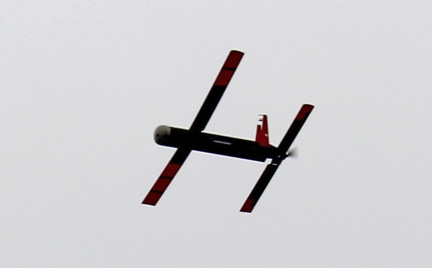
NOAA successfully deployed an unmanned aircraft, the Coyote, from a hurricane hunter into the eye of Hurricane Edouard last season, and will expand the use of this small unmanned aircraft this hurricane season. Planned flights timed to hurricanes will measure the regions of strongest winds at low altitudes in hurricanes and send that data in real-time to forecasters at NOAA’s National Hurricane Center.


Unmanned aircraft such as the Coyote will be used to measure the most violent parts of a storm. (Image Credit:NOAA)

Unmanned aircraft such as the Coyote will be used to measure the most violent parts of a storm. (Image Credit:NOAA)

Northern Gulf Institute scientists working with NOAA’s National Weather Service Lower Mississippi River Forecast Center will fly a small unmanned aircraft to study the Pearl River, looking at water levels, vegetation and impacts from storms. The research by the NOAA cooperative institute at Mississippi State University will be used to improve flooding forecasts and damage assessments after flooding in areas that are difficult to reach by manned aircraft, but often severely affected by hurricanes.

NOAA is also planning to deploy two underwater gliders north and south of Puerto Rico to collect data in the upper ocean before, during, and after a storm passes. These measurements will provide a better understanding of the ocean response to a hurricane’s passage, which in turn improves ocean models used in hurricane forecasts.

We must continue to push the boundaries of science to increase lead times for severe tropical storms, floods and other severe weather,” said Marks. “This season’s research is designed to find earlier clues to when a storm rapidly intensifies in order to help build a more weather ready nation.

Originally Published by Shannon Jones, AOML

0 Continue Reading →

Hurricane Scientists Bring a New Wave of Technology to Improve Forecasts

Scientists at NOAA’s Atlantic Oceanographic and Meteorological Laboratory are at the forefront of hurricane research to improve track and intensity forecasts. Every hurricane season they fly into storms, pour over observations and models, and consider new technological developments for how to enhance NOAA’s observing capabilities. The 2014 hurricane season will provide an opportunity to test some of the most advanced and innovative technologies, including unmanned hurricane hunter aircraft and sea gliders, which will help scientists better observe and, eventually, better predict a storm’s future activity.

The game plan: where we are and where we need to be

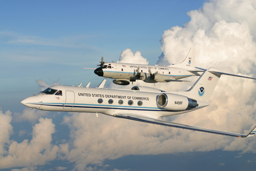
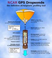
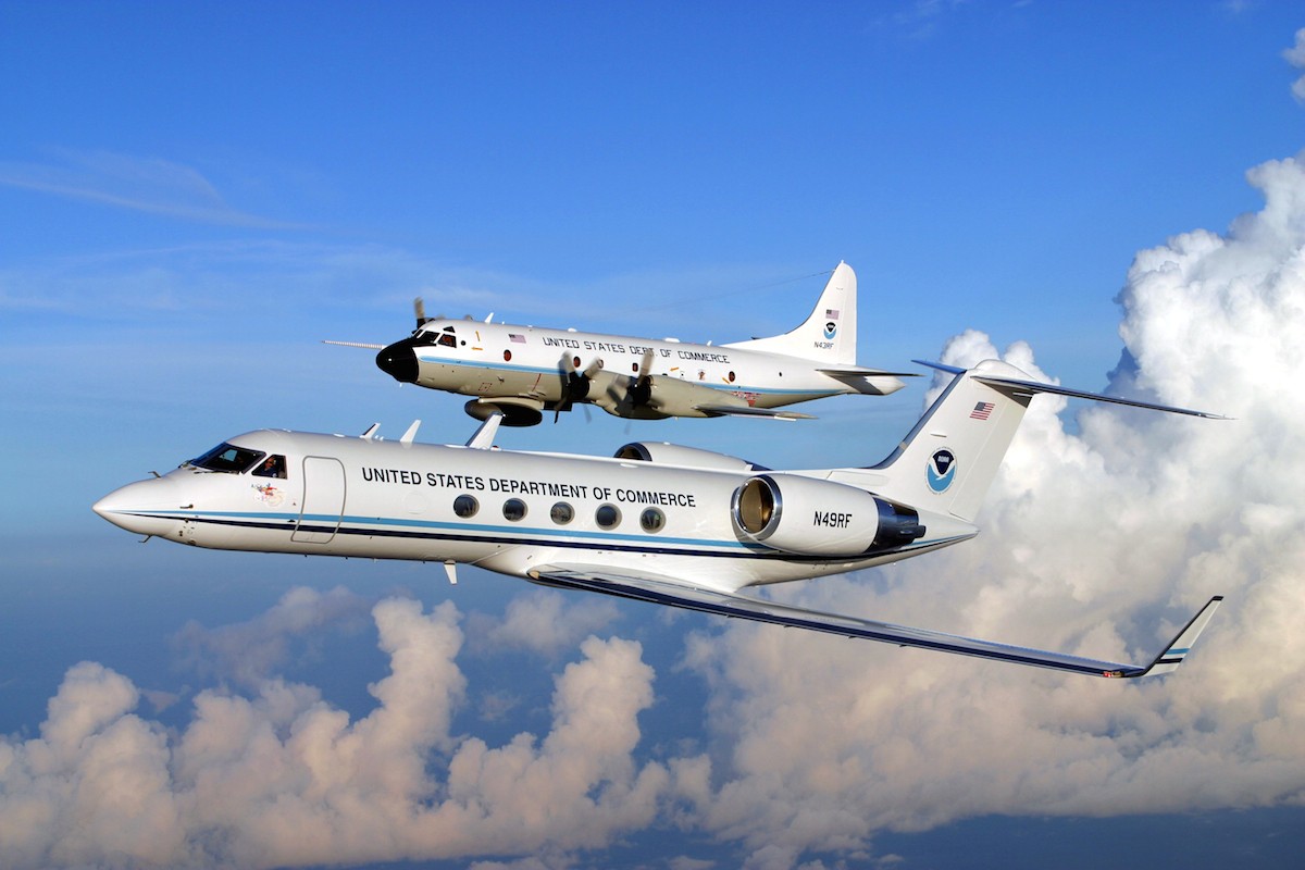
NOAA’s Aircraft Operations Center (AOC) maintains two P-3 Orions and a Gulfstream IV jet for hurricane observations. To collect data, NOAA’s hurricane researchers fly aboard these aircraft into and around the periphery of storms. A primary tool they use for measuring the hurricane environment is the dropsonde, a lightly weighted cylindrical tube equipped with a parachute and global positioning system technology. Dropsondes transmit their position every half second as they drift through a storm. These mini-weather stations are deployed from the belly of the aircraft and fall towards the ocean, sending data such as pressure, temperature, wind speed, wind direction, and moisture to scientists aboard the hurricane hunter aircraft.


NOAA's P-3 Orion an dG-IV hurricane hunter aircraft

NOAA’s P-3 Orion and G-IV jet. Photo credit: NOAA


While dropsondes are an excellent tool for measuring a storm’s atmospheric environment, their spatial coverage is limited. Dropsondes essentially obtain vertical profiles of a storm at discrete points. Other instruments on the aircraft measure storm properties at altitudes as great as 60,000 feet. However, NOAA’s hurricane hunter aircraft are unable to fly below 5,000 feet due to the extreme turbulence occurring between the ocean and atmosphere. This leaves a gap in the opportunity to collect potentially important data from the lower part of the storm, which may be essential to increasing the understanding of intensity change.

Congressional funding supports new unmanned aircraft

Post-Hurricane Sandy federal funding, the Disaster Relief Appropriations Act of 2013, provided NOAA with the opportunity to test new technology in hopes of better understanding and evaluating storm physics that drive intensity change. An unmanned weather drone, called the Coyote, will do just that.  The Navy originally designed the Coyote for maritime surveillance. NOAA plans to transition this unique platform into a “smart sonde” that can be used for hurricane science. During the 2014 hurricane season, the Small Unmanned Aircraft Vehicle Experiment will test the capability of the Coyote in storms, observing how well it handles severe winds and the harsh hurricane environment.


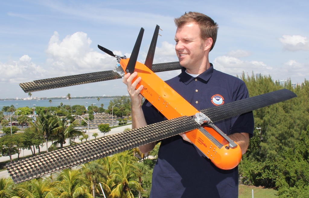
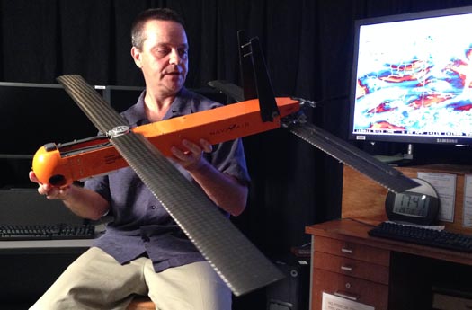
Dr. Joe Cione holds the Coyote UAS

Dr. Joe Cione of AOML’s Hurricane Research Division displays the Coyote UAV


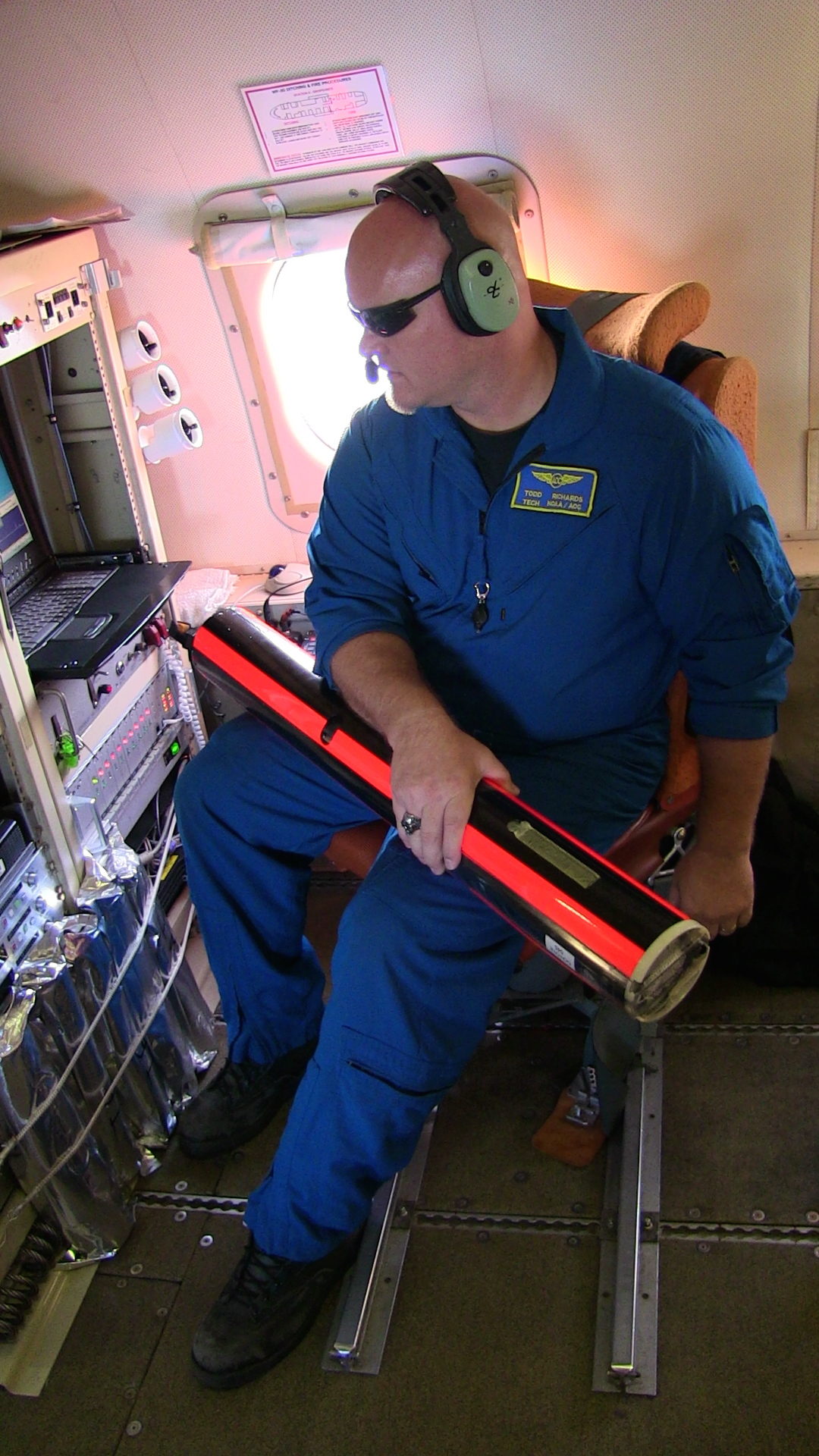
Scientists will deploy the seven pound unmanned aircraft from the P-3 Orion in the same way as the dropsondes. However, instead of drifting downward towards the ocean surface, the Coyote will open its six-foot wingspan and fly through the storm.  It can be controlled from miles away but will typically be piloted by scientists onboard the P-3s. Its relative lightweight design requires the Coyote to fly with the wind currents, but it will be directed up, down, and sideways to navigate specific flight patterns to measure the inner core and lowest altitudes of the storm.


Hurricanes are fueled by warm ocean water, and vital information needed to better understand and predict intensity change may rest close to the sea surface where manned aircraft cannot fly and the dropsondes only pass through for a few seconds. With its ability to fly for two hours in this region, the Coyote provides the opportunity for much more complete data collection, in comparison to the traditional dropsonde.

Adding a new twist to existing technology

The traditional dropsonde itself will also receive an upgrade for the 2014 season with the addition of a sensor to measure sea surface temperature at splashdown. This additional last data point will provide a critical piece of information at the air-sea interface, the environment where energy transfer occurs and is most challenging to observe in a hurricane environment.

(image credit: NCAR)
 dropsonde

Diving into the ocean to improve hurricane forecasts

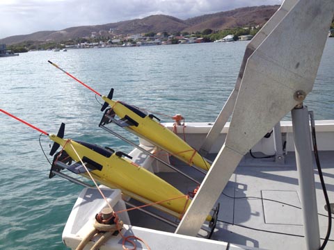
The 2014 season will also feature two sea gliders, remotely operated profiling instruments that dive below the ocean surface and then resurface to transmit observations of temperature and salinity. NOAA is testing two ocean gliders in critical hurricane regions of the Caribbean north and south of Puerto Rico. The gliders were deployed in July and will be recovered at the end of hurricane season.  The gliders will profile the upper ocean about 10 times daily, diving to a depth of 1,000 feet and collecting data as they ascend. When a sea glider breaks the surface, its data will be transmitted to AOML and made available in near-real time via the web.


Sea Gliders ready for deployment off of Puerto RicoTwo gliders ready for deployment from the R/V Sultana,

off the coast of Puerto Rico (credit: NOAA/AOML)


In addition to these new technologies, the Disaster Relief Appropriations Act of 2013 also provided funding to assess the impact of data from these and other instruments in hurricane forecast models. AOML will make use of its Observing System Simulation Experiment expertise to evaluate how such ocean observations can best improve hurricane forecasts of track and intensity change.


The Hurricane Research Division is one of AOML’s three scientific research divisions. Scientists with HRD, and its precursors, have been flying into hurricanes for almost 60 years and regularly collaborate with other federal, university, and international  partners to leverage that expertise to advance hurricane science and forecasting globally. Follow the latest HRD activities during this research season on Twitter or by visiting the division website.

Originally Published August 2014 by Shannon Jones


0 Continue Reading →

All Systems Are Go for NOAA to Release an Unmanned Aircraft Within a Hurricane


Dr. Joe Cione of AOML's Hurricane Research Division displays the Coyote UAV
Dr. Joe Cione of AOML’s Hurricane Research Division
displays the Coyote UAV (Credit NOAA/AOML)

NOAA hurricane hunters are prepared to enter a new chapter in the use of unmanned aircraft systems: deploying an unmaned aircraft from an airplane inside a hurricane. Starting on September 14, 2014, NOAA’s hurricane hunting manned aircraft fleet will fly into position to observe any developing tropical systems in the Atlantic using this new tool. The Coyote unmanned aircraft will be the first unmanned aircraft deployed directly inside a hurricane from NOAA hurricane hunter aircraft. The goal of the Coyote is to collect temperature, pressure and wind observations below 3,000 feet, where manned aircraft can not fly safely.

The Coyote UAS is ready to launch out of the P3.
The Coyote UAS is
ready to launch.
(Credit: NOAA/AOML)  

Post-Hurricane Sandy federal funding, the Disaster Relief Appropriations Act of 2013, provided NOAA with the opportunity to test this new technology in hopes of better understanding and evaluating how storms evolve and intensify.

This new unmanned aircraft will do just that.  The Navy originally designed the Coyote for maritime surveillance. NOAA is using it now for hurricane science.

During the 2014 hurricane season, the Small Unmanned Aircraft Vehicle Experiment will test the capability of the Coyote in storms, observing how well it handles severe winds and the harsh hurricane environment.

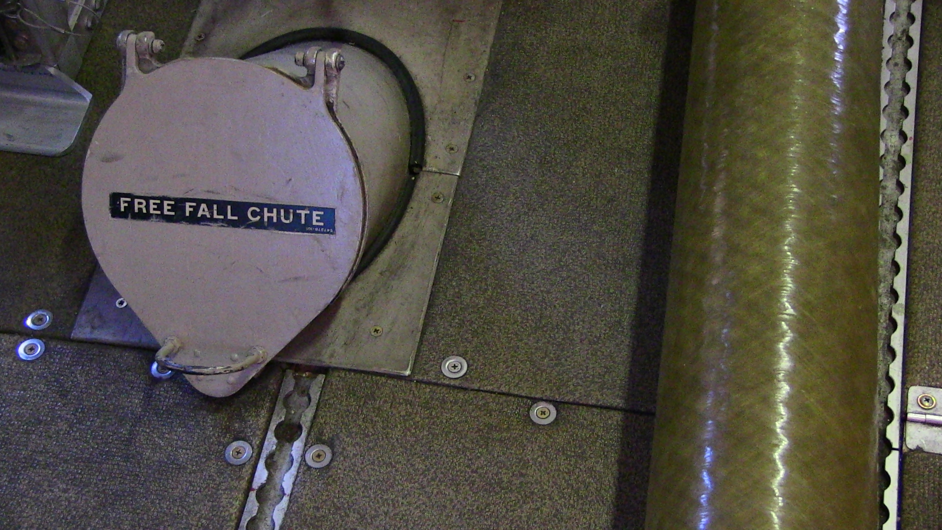
Scientists aboard NOAA’s P-3 Orion aircraft will deploy the seven-pound unmanned aircraft from a free fall chute in the belly of the plane. The Coyote is designed to then

Chute on P3 used to launch the Coyote.
(Credit: NOAA/AOML)  
 

open its six-foot wingspan and fly through the storm. It can be controlled from miles away but will be piloted by scientists onboard the P-3s. Its relative lightweight design requires the Coyote to fly with the wind currents, but it will be directed up, down, and sideways to navigate specific flight patterns to measure the storm’s inner core and storm activity at the lowest altitudes.

Hurricanes are fueled by warm ocean water, and vital information needed to better understand and predict intensity change may rest close to the sea surface where manned aircraft cannot fly. With its ability to fly for up to two hours in this region, the Coyote will provide much more complete data than traditional air-deployed weather instruments, called dropsondes.

NOAA conducted a test-launch of the coyote from the NOAA P-3 aircraft in early September. That successful flight demonstrated the capability of the unmanned aircraft to exit the aircraft, spread its wings, execute flight maneuvers at the commend of a pilot on the P-3, and collect and transmit meteorological observations back to the P-3.

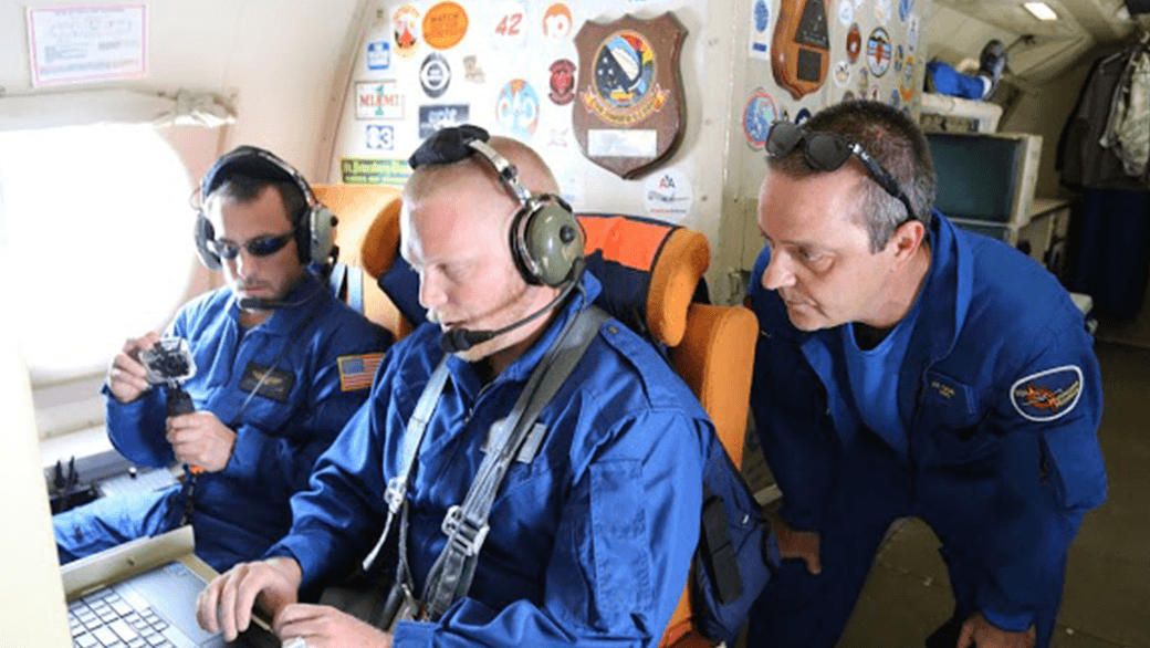
The crew monitors the in-flight Coyote UAS from the piloting station on the P3.
The crew monitors the in-flight Coyote UAS from the
piloting station on the P3. (Credit: NOAA/AOML)

In addition to providing support for testing  new technologies, the Disaster Relief Appropriations Act of 2013 also provided funding to assess of the value of incorporating data from these and other instruments to hurricane forecast models. NOAA’s Atlantic Oceanographic and Meteorological Lab  will evaluate how such ocean observations can best improve hurricane forecasts of track and intensity change.

Originally Published in September 2014 by Shannon Jones

0 Continue Reading →

NOAA Launches Coyote UAS from P-3 Hurricane Hunter into Hurricane Edouard

NOAA successfully deployed unmanned aircraft from a NOAA P-3 Hurricane Hunter directly into a hurricane for the first time. NOAA deployed four Coyote Unmanned Aircraft Systems (UAS) in Hurricane Edouard during flights conducted September 15-17, 2014 out of Bermuda. Scientists on board the P-3 aircraft received meteorological data from the Coyote UAS in both the eye and surrounding eyewall of Hurricane Edouard.

“Data from these new and promising technologies have yet to be analyzed but are expected to provide unique and potentially groundbreaking insights into a critical region of the storm environment that is typically difficult to observe in sufficient detail,” said Joe Cione, a NOAA Hurricane Researcher and Principal Investigator for the Coyote project.

Post-Hurricane Sandy federal funding, the Disaster Relief Appropriations Act of 2013, provided NOAA with the opportunity to test this new technology in hopes of better understanding and evaluating how storms evolve and intensify. The goal of the Coyote is to collect temperature, pressure and wind observations below 3,000 feet, where manned aircraft cannot fly safely.

NOAA’s Aircraft Operations Center (AOC) maintains two P-3 Orion turboprop aircraft and Gulfstream-IV jet for hurricane observations. These aircraft also flew in Hurricane Edouard as a part of a larger experiment to collect data for hurricane model evaluation. These hurricane research efforts are designed to provide insight and understanding that translates into improved hurricane model forecasts.  The improvement of this Environmental Intelligence gives forecasters tools to help prepare communities for possible hurricane impacts.

The Government of Bermuda hosted these missions and effectively served as international partners in NOAA’s effort to improve hurricane forecasts for all countries affected by these storms. NOAA looks forward to continued research into the application of air-deployed unmanned aircraft to support and improve hurricane research and forecasts.
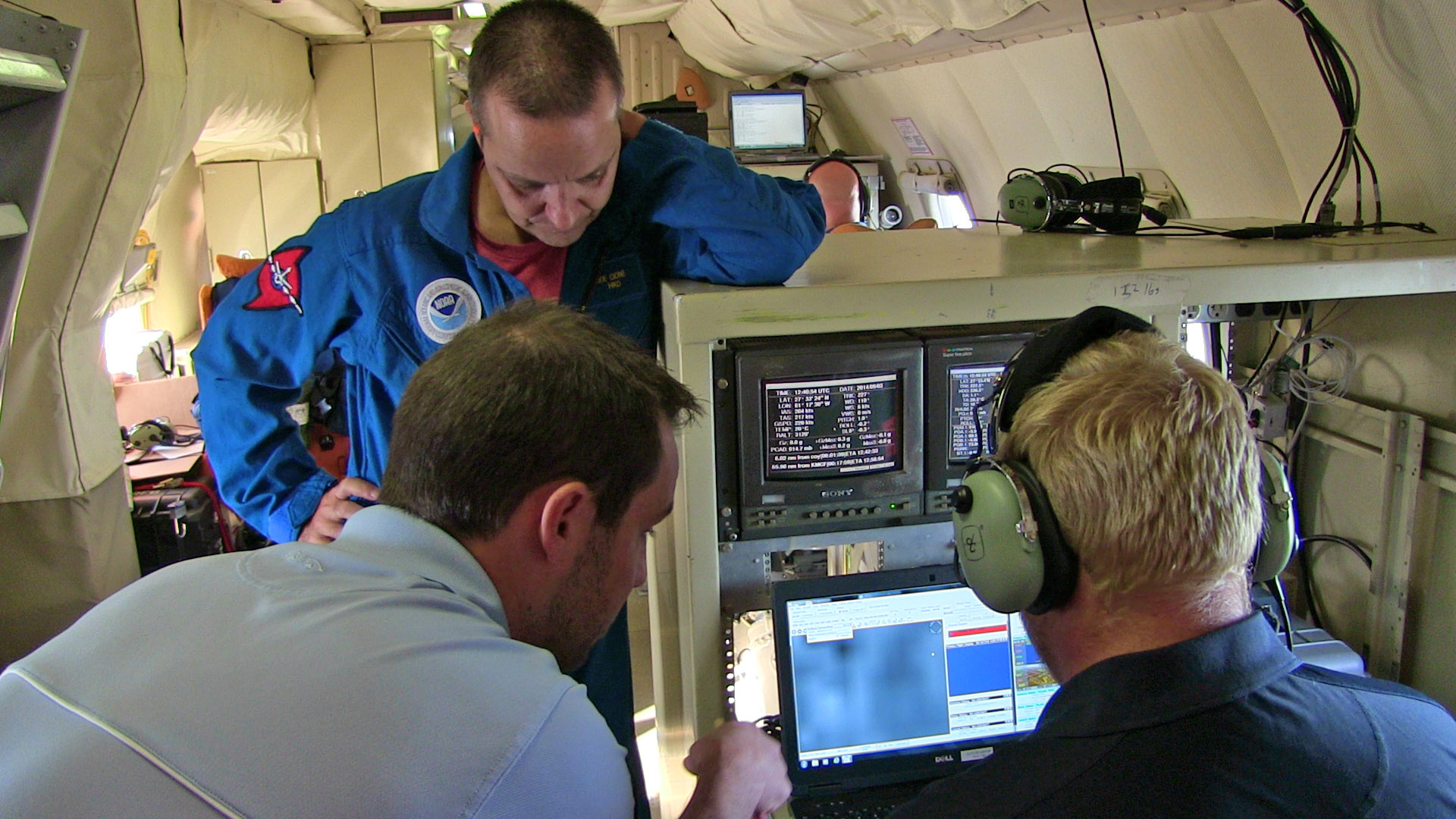
  • Drew Osbrink and Eric Redweik of Sensintel and NOAA’s Dr. Joe Cione monitor data from the Coyote after it was launched into Hurricane Edouard. (Credit: NOAA)


  • RDML Anita Lopez shakes hands with Bermuda Premier Michael Dunkley.

    (Credit: NOAA)
     

  • Coyote UAS aboard NOAA WP-3D Orion. (Credit: NOAA)

Originally Published September 2014 by Shannon Jones

0 Continue Reading →