Skip to Content

Category Archives: Oceans Influence on Climate & Weather

AOML Joins Ocean Acidification Program Research Cruise Along U.S. East Coast

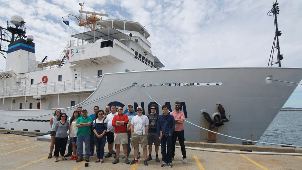
A team of researchers, including scientists from AOML and the University of Miami, set sail June 19th on a research cruise aboard the NOAA ship Gordon Gunter to provide increased understanding of ocean acidification and its drivers along the U.S. East coast. The cruise, which is part of a larger effort supported by NOAA’s Ocean Acidification Program, investigated near-shore and deep waters, and provided researchers with more detailed information about changing ocean chemistry in different environments.

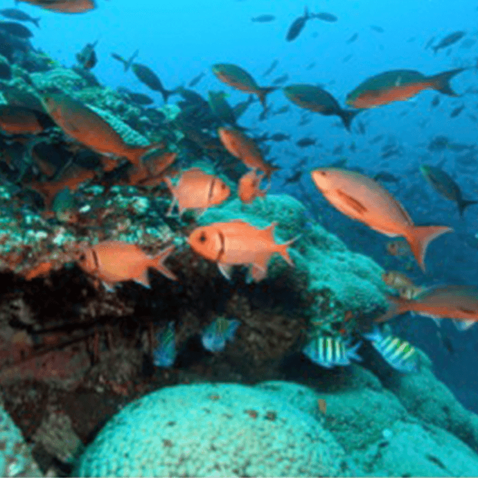
Ocean acidification is a fundamental change in ocean chemistry involving a progressive decline in pH over decades caused primarily by the absorption of increasing carbon dioxide emissions. Additionally, freshwater and nutrient run off from the coasts can alter seawater chemistry. The rise in dissolved CO2 and concurrent drop in pH (lower pH indicates higher acidity), changes ocean chemistry in a way that robs marine organisms, such as mollusks and corals, of the carbonate ions they need to build shells and skeletons. At the same time, the increasing acidity can erode the structures they’ve already built, and appears capable of disrupting their bodies in other ways that make it hard for them to thrive.

The Gunter traveled north from Newport, RI to survey the waters of the Nova Scotia Shelf and then steamed south, surveying waters close to shore to provide detailed information about water chemistry within the Gulf of Maine, Long Island Sound, the Mid-Atlantic and Southern Bight regions. The ship also investigated central Florida waters before reaching Miami on July 24. Similar Ocean Acidification Program cruises have taken place on the U.S. West Coast and the Gulf of Mexico. Understanding why and how fast ocean chemistry is changing along our coasts will allow scientists to better predict future changes, explore ways to adapt to those shifts, and provide insight into where marine organisms may be at greatest risk along U.S. coasts.

AOML researchers measured inorganic carbon dioxide, partial pressure of carbon dioxide, and collect nutrient samples to be analyzed later at AOML. By collecting and analyzing samples in near-shore and deeper waters, scientists will better understand what drives the process of ocean acidification in different regions of the East Coast. The East Coast has a broad shallow shelf, which could be a significant source of potentially corrosive, freshwater discharge from rivers into the coastal ocean. Sampling along the coast will allow scientists to understand how fresher waters, coastal influences, and phytoplankton may alter our ocean chemistry. This environmental information about ocean acidification is essential to predicting its effects on important marine resources, so that communities can mitigate and adapt to these changes.

0 Continue Reading →

Indian Ocean Plays Key Role in Global Warming Hiatus

The earth is warming, but temperatures in the atmosphere and at the sea surface that steadily rose in the last half-century have leveled off and slowed in the past decade, causing the appearance of an imbalance in Earth’s heat budget. Scientists are looking into the deep ocean to determine where this additional heat energy could be stored, and recently traced a pathway that leads to the Indian Ocean.

In a study published May 18 in Nature Geoscience, oceanographers from the University of Miami’s Rosenstiel School, Cooperative Institute for Marine and Atmospheric Studies (UM/CIMAS), NOAA and their colleagues identified a key mechanism that explains the apparent contradictions associated with the recent global warming hiatus. Building upon previous studies that suggest enhanced heat uptake in the tropical Pacific Ocean as the major source of the imbalance, the new study tracked this excess heat from the Pacific to the Indian Ocean via Indonesian pathways.

Since the 1950s, global average surface air temperatures have increased steadily, with the warming attributed to greenhouse gases originating from human activities. Since the start of the 21st century however, global surface warming has almost stalled. This contradicts with the amount of net radiation entering Earth at the top of the atmosphere, which continues to suggest an increasingly warming planet. The slowdown of surface warming was the focus of a series of studies that sought to identify and track the causes of this process.

Researchers initially pegged the tropical Pacific as the major source of heat uptake, theorizing that the basin was storing a large portion of the global heat imbalance over the last decade, thereby causing the atmosphere to warm less. Natural climate variability processes such as El Niño/Southern Oscillation (ENSO), a cycle of warm and cold sea surface temperature in the tropical Pacific Ocean, drive wind patterns and ocean currents across the region. Since the turn of the century, the cold phase of ENSO, known as La Niña, has persisted, increasing the uptake of warm surface waters in the subtropics. This process and others have enhanced the uptake of heat from the atmosphere to the top 2,000 ~ 3,000 feet of the ocean.

While uptake in the Pacific as a result of La Niña-like conditions may have answered the initial question regarding the heat missing from the atmosphere, findings from the recent study indicate that Pacific heat has been slowly decreasing and that the excess heat has been transported elsewhere.

“When I first saw from the data that Pacific heat was going down, I was very curious and puzzled,” says the study’s lead author Dr. Sang-Ki Lee, a climate researcher with UM/CIMAS and NOAA’s Atlantic Oceanographic and Meteorological Laboratory.

Results from the study suggest that the excess heat is being stored in the Indian Ocean, which has seen an unprecedented rise in heat over the past decade. Researchers studied observations going back to 1950 and noticed that the Indian Ocean heat uptake stayed relatively low until 2003 or so. From that point forward, observations indicated that heat began to build in the Indian Ocean and there was no evidence to support that the source was from the atmosphere. By running simulations from a global ocean-sea ice model to track the pathway of heat, researchers found that the heat originally stored in the Pacific was transported by a strong ocean current, known as the Indonesian Throughflow, and ended up in the Indian Ocean. The heat flux into the Indian Ocean via the Indonesian pathway means that the Indian Ocean is increasingly important in modulating global climate variability and is now home to 70 percent of all heat taken up by global oceans during the past decade.

The study helps resolve an important debate regarding the warming hiatus. Scientists theorize the Pacific played a role in the warming hiatus, yet all observations indicated that total heat in the Pacific basin had not increased as expected. This study reveals that the Pacific was an intermediary in the heat storage process, but not the final destination, explaining the lack of change in Pacific heat.

Lee has several thoughts about future effects of this warm deep ocean water. In its current location, Lee said it’s possible that the warm water in the Indian Ocean could affect the Indian Monsoon, one of the most important climate patterns in the world that affects more than 1 billion people. What it means for future El Niño cycles is not immediately clear. However, Lee noted that the warm water in the western Pacific, which provides the energy needed to produce intense El Niño events, has been partially discharged into the Indian Ocean, suggesting weaker El Niño events in the near future.  Lee also indicates that the heat content is likely to continue moving with global ocean currents and may find its way into the Atlantic basin in the coming decades.

“If this warm blob of water in upper Indian Ocean is transported all the way to North Atlantic, that could affect the melting of Arctic sea ice,” Lee said. “That can also increase hurricane activity and influence the effects of drought in the U.S, but future studies are required to validate these hypotheses.”


Originally Published in May 2015 by Edward Pritchard

0 Continue Reading →

Scientists Find Southern Ocean Removing CO2 from the Atmosphere More Efficiently

A research vessel ploughs through the waves, braving the strong westerly winds of the Roaring Forties in the Southern Ocean in order to measure levels of dissolved carbon dioxide in the surface of the ocean. (Nicolas Metzl, LOCEAN/IPSL Laboratory).

0 Continue Reading →

Study Provides Local-scale Projections of Coral Bleaching Over the Next 100 Years

In a new study published April 1 in Global Change Biology, NOAA oceanographers and colleagues have developed a new method to produce high-resolution projections of the range and onset of severe annual coral bleaching for reefs in the Gulf of Mexico and Caribbean. The scientists built on a previous study that used global climate models from the Fifth Assessment Report of the Intergovernmental Panel on Climate Change that produced projections at a very coarse resolution of about 70 miles or 100 kilometers. By using a regional oceanic model and an approach called statistical downscaling, the scientists calculated when increasingly warmer waters would cause severe bleaching on an annual basis. The resulting local-scale projections of bleaching conditions, at a resolution of about 6 miles or 10 kilometers, will help managers include climate change as a consideration in planning and conservation decisions.

Coral bleaching is a major threat to coral ecosystems and primarily occurs when ocean temperatures are warmer than has been normal in the past. Temperature stress disrupts the relationship between corals and the algae that live within their tissues; a relationship that usually benefits both parties. The algae are expelled as they cannot photosynthesize under the extreme conditions. The white limestone coral skeleton becomes visible through tissue that is now transparent since the expelled algae give corals their vibrant colors. Extensive coral bleaching events, called ‘mass bleaching’, have increased in frequency and severity over the past two decades and have contributed to overall reef loss globally.

The loss of coral reefs results in significant ecological, social and economic loss. Coral reefs provide rich habitat for valuable fisheries that people depend on for food. They also serve as protective buffers to coastlines by absorbing wave energy from storms, and they boost local economies by attracting tourists who fish, dive and explore these underwater treasures.

A main conclusion of the study is that almost all coral reef locations in the Gulf of Mexico and Caribbean are projected to experience bleaching conditions every yearby mid-century. This result applies to the past coarse-resolution projections as well as the new high-resolution projections. However, the high-resolution projections show there is great within-country variation in the projected timing of extreme conditions. There are locations within many countries where some reefs are projected to experience annual bleaching conditions 15 or more years later than other locations. This applies to reefs in Florida, the Bahamas, Cuba, Puerto Rico, the Dominican Republic, Turks and Caicos, and Mexico. Reefs projected to experience bleaching conditions later are conservation priorities. These locations are a type of refuge, and are among the locations most likely to persist as the climate changes.

“At these locations, referred to in the study as ‘relative refugia’, lower rates of temperature increase and fewer extreme events mean reefs have more time to acclimate and adapt to climate change,” says study lead Dr. Ruben van Hooidonk, a coral and climate researcher with the Cooperative Institute for Marine and Atmospheric Studies at the University of Miami’s Rosenstiel School and NOAA’s Atlantic Oceanographic and Meteorological Laboratory.

Coastal and environmental managers, as well as conservation staff, throughout southern Florida, the Gulf of Mexico and Caribbean can now use the projections to identify local conservation priorities. Managers may decide to preferentially protect these locations within marine protected area networks or may target a range of other actions to these relative refugia to reduce stress caused by human activities.

Bob Glazer of Florida’s Fish and Wildlife Conservation Commission said he welcomed the new research. “Coral bleaching poses a grave threat to coral reefs and these high-resolution projections provide vitally needed spatial information about the degree of threat and inform opportunities to make better management decisions.”

The study authors also compare the two approaches they used to produce the high-resolution projections. Using the regional ocean model represents dynamical downscaling, which is state-of-art but is expensive in time, money and effort. The regional ocean model was developed by the Geophysical Fluid Dynamics Laboratory at NOAA and has been set up for use in the Gulf of Mexico and Caribbean by oceanographers at AOML.

In contrast, the statistical downscaling method the authors developed uses observed relationships between historical temperatures and current conditions to modify the outputs from the global climate models. This method has the advantage of being far less resource-intensive than dynamical downscaling. The study authors found that the results from the two very different approaches were very similar. This gives the team confidence that statistical downscaling should be applied for all of the world’s coral reefs, which the team plans to undertake over the coming year.

NOAA’s Reef Manager’s Guide, which provides information on the causes and consequences of coral bleaching, outlines some of the management strategies and tools that can help reef managers address the coral bleaching threat. Find out more here.This study was funded by NOAA’s Coral Reef Conservation Program and supported by NOAA AOML. The Open Access paper can be downloaded by clicking the thumbnail to the left.

Originally published April 1st, 2015 by Edward Pritchard

0 Continue Reading →

Gulf of Mexico Marine Food Web Changes Over the Decades

New NOAA study finds natural climate cycles and

human activities are drivers of change

Scientists in the Gulf of Mexico now have a better understanding of how naturally-occurring climate cycles–as well as human activities–can trigger widespread ecosystem changes that ripple through the Gulf food web and the communities dependent on it, thanks to a new study published Saturday in the journal Global Change Biology.

A team of NOAA oceanographers spent three years reviewing over 100 indicators derived from environmental, fishery, and economic data, including sea surface temperature, currents, atmospheric patterns, fishing effort, harvest, and revenues. Through extensive analysis, they found a major ecosystem reorganization that appeared to be timed with a naturally-occurring climate shift that occurred around 1995.

The climate phenomenon is known as the Atlantic Multidecadal Oscillation (AMO), a climate signal in the North Atlantic Ocean that switches between cool and warm phases, each lasting for 20-40 years at a time. The AMO, which was in a cool phase between 1965 until 1995 and has been in a warm phase since, influences global ocean and weather conditions in the northern hemisphere such as hurricane activity in the Atlantic ocean and the severity and frequency of droughts.

However, the AMO is not as extensively studied as other climate phenomena, such as El Nino, and this study is the first to investigate what scientists hope will be many future studies examining how the AMO influences ecosystem-scale change in the Gulf. Scientists hope this work will spur interest in further studying this phenomenon and its implications for the marine environment in this region.

“These major ecosystem shifts have probably gone unrecognized to date because they are not apparent when considering single species or individual components of the ecosystem,” said lead investigator Dr. Mandy Karnauskas of NOAA’s Southeast Fisheries Science Center. “Only when we put a lot of things together — including currents, hypoxia, fish abundances, fishing effort, and more — does a strong climate signal emerge.”

Additionally, scientists observed shifts in many species around the late 1970s coincident with the advent of the U.S. Magnuson-Stevens Fishery Conservation and Management Act– a policy designed to set rules for international fishing in U.S. waters, make the expansion of certain fisheries more favorable for economic development, and ensure the long-term sustainability of the nation’s fish stocks.

Other human influences that are not as pronounced–or easily distinguishable–include coastal development, agricultural runoff, oil spills, and fishing. Natural phenomena like coastal storms and hurricanes play a role as well.

The scientists expect their study to be useful to resource managers throughout the Gulf region. While managers cannot control Earth’s natural climate cycles, they may need to consider how to alter management strategies in light of them, in order to effectively meet their mandates.

Karnauskas’ team included other scientists from NOAA Fisheries as well as NOAA’s Atlantic Oceanographic and Meteorological Laboratory, the University of Miami, and the University of Texas.

Click on the thumbnail to the left to download the full study.

Originally Published in March 2015 by Shannon Jones

0 Continue Reading →

The Galápagos Islands: A Glimpse into the Future of Our Oceans

A study of Galápagos’ coral reefs provides evidence that reefs exposed to lower pH and higher nutrient levels may be the most affected and least resilient to changes in climate and ocean chemistry.

The Galápagos Islands are a unique habitat that allows scientists to study many ecological conditions, including exposure to naturally high levels of oceanic carbon dioxide. The coasts of the Galápagos are bathed in upwelled water from the deep ocean. This upwelled water has high carbon dioxide concentrations. Greater levels of carbon dioxide result in lower pH levels in seawater, making it more acidic.  Waters with high carbon dioxide can have negative affects on some organisms, like corals, that build their skeletons underwater. These naturally high levels of carbon dioxide surrounding the Galápagos are a present day example of the conditions expected throughout the rest of the tropics by the 2050’s.

Warm water temperatures are another factor affecting the Galápagos. The 1982-1983 El Niño Southern Oscillation warming event increased water temperatures in the Galápagos 3-4 degrees C above the usual maximum sea temperatures.  This warming physically stressed Galápagos corals, causing them to expel the algae living in their tissues and become completely white or bleached. This and other similar coral bleaching events coupled with the naturally occurring high levels of carbon dioxide, made it difficult for coral reefs to rebuild their calcium carbonate skeletons.  None of the Galápagos’ southern reefs show signs of revival and the only reef recovering is off the far northern island, Darwin.

As a coral ecologist and lead researcher for NOAA’s National Coral Reef Monitoring Program, Derek Manzello gathered an abundance of data on the seawater surrounding the southern Galápagos Islands, but he had limited information on the seawater in the northern islands. Thanks to the Khaled bin Sultan Living Ocean’s Foundation, Manzello and his team were able to venture to Darwin and conduct field studies comparing corals and seawater chemistry between the southern and northern islands. They discovered that at the present day acidification levels, corals can recover from severely stressful events, but their recovery is dependent on water quality conditions.

In the Galápagos study, waters have lower pH and higher nutrients in the southern Islands.  The team measured changes in coral density to compare growth rates of corals in the southern and northern waters. Corals, like trees, have an annual banding pattern, which is used to determine annual growth rates. Manzello’s team took core samples from corals, and examined their density bands with a micro-CT scanner, producing three-dimensional X-ray images.  Using these images, scientists observed healthier annual growth rates and density patterns for corals in the northern waters.  Corals in the southern waters, which were exposed to elevated nutrients and high CO2 levels due to upwelling, showed less skeletal growth.

“The Galápagos reefs provide one piece of the science of predicting how coral reefs will fare with continued warming and ocean acidification.” Says Manzello “There are other areas with high levels of carbon dioxide that do not experience as high of nutrient values as the Galápagos. This allows us to understand how acidification may impact the future of coral reefs through the worlds oceans.”

With support from NOAA’s Coral Reef Conservation and Ocean Acidification Programs, NOAA oceanographers can continuously evaluate, monitor, and study the effects of ocean acidification. Learn more about AOML’s collaborative ocean acidification efforts in the Island of Maug and the Florida Keys.

  • Only one surviving reef off the coast of Darwin Island in the northern Galápagos Islands.
    Photo Credit: Joshua Feingold

  • Coral Reefs off the coast of Floreana Island in the Galápagos Islands photographed in 1976, before the 1982-1983 El Niño Southern Oscillation warming event. Photo Credit: Peter Flynn

  • Coral reefs off the coast of Floreana Island in the Galapagos Islands photographed in 2012, after stressful environmental conditions destroyed the reef. Photo Credit: Derek Manzello

Originally Published in January 2015 by Shannon Jones

0 Continue Reading →

Research Fit for a King Tide

King Tide: tide at 8:30am marks a before with low watermark on a bridge in Coconut GroveKing Tide: tide at 10:30am shows high watermark on a bridge in Coconut Grove
King Tide: tide at 10:30am shows high watermark on a bridge in Coconut GroveKing Tide: tide at 8:30am marks a before with low watermark on a bridge in Coconut Grove

AOML scientists part of team sampling water quality of extreme high tide floodwaters on Miami Beach

The colloquial term ‘king tides’, referring to the highest astronomical tides of the year, is now part of most Miami Beach residents and city managers’ vocabulary. Exacerbated by rising seas, these seasonal tides can add up to 12 inches of water to the average high tide, threatening the urbanized landscape of Miami Beach. During these events, AOML’s Microbiology Team is on the scene to investigate these tidal waters as they rise and recede. The microbiologists are part of a research consortium for sea level rise and climate change, led by Florida International University’s Southeast Environmental Research Center. The research effort focuses on collecting samples and monitoring water quality at locations along the Biscayne Bay watershed where the City of Miami Beach has installed pumps to actively push these super-tidal floodwaters back into the bay.

Because Miami Beach now regularly floods during super-tidal events or severe storms, it is important to understand how such coastal inundation events may cause land-based sources of pollution to enter the marine environment and how this pollution may impact both the ecosystem and human health.

“We don’t really know what comes from brackish water tidal floods in a built environment like Miami Beach, where water can spill over roads, yards, parking lots, and commercial sites” said AOML’s Dr. Chris Sinigalliano. “We have not yet measured how such tidal floodwater is similar or different to regular stormwater in the kinds of contaminants it accumulates and the potential risks associated with it.”

Researchers participating in this sampling effort continuously monitor and collect water samples over a 5-hour period near city pumps and storm drains where floodwaters re-enter Biscyane Bay. Onshore sampling sites include Maurice Gibb Memorial Park, 14th Street, and 27th Street at Indian Creek Drive. Samples are also collected by boat along canals and waterways that feed into the bay. During sampling, physical water properties such as temperature, salinity, pH, turbidity, and dissolved oxygen content are also measured.

The extent of flooding in the city during the king tides varies from year to year, especially around the area of Gibbs Memorial Park, due to Miami Beach’s pumping efforts.  As the tidal waters recede, the discharges from the area of 14th Street generate noticeable plumes of turbid water in the bay, which scientists sample every hour.

The samples collected are brought back to the lab, where scientists prepare for hours of filtration and examination. FIU will test for a wide array of nutrients and biogeochemical markers while AOML tests for a variety of bacterial contamination markers to characterize the microbial water quality of the samples.

AOML also helps develop and validate molecular genetic techniques for analyzing the sources of various bacterial contaminants, a process known as ‘Molecular Microbial Source Tracking’. This analysis will help scientists, managers, and stakeholders understand what types of microbial pollutants exist in the tidal floodwaters and the possible environmental impacts of pumping this water back into the bay. Overall, AOML’s contributions to the king tide sampling effort include field sampling, analytical detection, measurement of microbial contaminants, including specific fecal-indicating bacteria, and identification of their potential sources using the Molecular Microbial Source Tracking method.

AOML scientists will also measure live enterococci (the fecal bacteria used for regulatory water quality monitoring of marine bathing waters) and quantify the abundance of specific source tracking bacteria. These source-tracking methods can determine the animal source the fecal bacteria originated from, including human, dog, birds, cows, and pigs.

Knowing the potential source of contamination provides actionable ‘Environmental Intelligence’ that can inform managers as they address contamination problems. Sewage and septic contamination is a human marker, terrestrial runoff can be linked to a canine marker, and agricultural waste contamination is linked to pig, cattle, and/or horse markers. Bird markers can also be detected and can indicate how much fecal contamination may be coming from seabirds and waterfowl.

FIU’s Southeast Environmental Research Center is leading the floodwater-sampling project and has provided the primary funding. This relatively small-scale pilot study leverages FIU’s partnerships with NOAA-AOML, the University of Miami, and Nova Southeastern University.

The analytical results from all participating laboratories will take several months to compile. A summary of the results will be made publicly available on FIU and AOML’s websites in order to inform stakeholders and interested parties.

The collective water quality information gathered from the king tide floodwaters on Miami Beach will be integrated across the multi-institutional research team. Results could further the understanding of the environmental impacts from tidal flooding of urban coastal landscapes and improve understanding of current and future impacts of sea level rise.

Originally Published October 2014 by Shannon Jones

0 Continue Reading →

Volcanic Island of Maug Provides Natural Lab for Ocean Acidification

diver swimming at maug reefs 

CIMAS researcher Ian Enochs “diving in champagne” at the Maug reefs Photo credit: Open Boat Films/NOAA


Ian Enochs, a scientist with NOAA’s Cooperative Institute for Marine and Atmospheric Studies at the University of Miami, traveled in May to the Island of Maug in the Pacific Ocean as part of a NOAA expedition aboard NOAA Ship Hi’ialakai to study coral reef ecosystems. The expedition was led by NOAA’s Pacific Island Fisheries Science Center Coral Reef Ecosystem Division and the Pacific Marine Environmental Lab’s Earth-Ocean Interaction group. Enochs focused his research on underwater vents that seep carbon dioxide into the Pacific.

Why journey to the Island of Maug to study ocean acidification?

Maug is a unique natural laboratory that allows us to study how ocean acidificationaffects coral reef ecosystems. We know of no other area like this in U.S. waters. Increasing carbon dioxide in seawater is a global issue because it makes it harder for animals like corals to build skeletons.

What is the Island of Maug like?

Maug is an uninhabited volcanic island in the Commonwealth of the Northern Mariana Islands about 450 miles north of Guam. The volcano breaks through the ocean surface in three areas to form islands and the relatively shallow water surrounding these islands is full of coral reefs. The underwater vents that seep carbon dioxide are found on the side of the caldera or crater formed by the volcano. Usually when I scuba dive, the moment I enter the water, air bubbles surround me and fade away quickly. On Maug, the bubbles never ceased and it felt like I was swimming in a glass of champagne.

collecting underwater gas samples
A funel is used to collect carbon
dioxide gas bubbles from the
seeps near the coral reefs.
Photo credit: Open Boat Films/NOAA 

What are your goals for studying the carbon dioxide vents?

We’re mapping carbonate chemistry over time and space to examine the extent of carbon dioxide at the site. We’re looking at how that chemistry changes over this area as you get farther from the vents and what corresponding changes there are in the coral community. We hope to learn more about which coral species are especially sensitive to elevated carbon dioxide and which may be resilient. Finally, we will look at how elevated carbon dioxide levels in seawater may influence the response of various organisms over time, including their growth rate.

What does your sampling show so far?

The carbon dioxide appears to be strongly influencing the growth of corals and algae in a small area around the vents. While there is weedy algae near the vent due to high levels of carbon dioxide, this gives way to healthier coral reefs as you get farther away from the site.

How do you measure these effects over time?

This first trip has allowed us to begin measuring the effects of carbon dioxide and to place instruments in the area that will continuously measure temperature, light, the partial pressure of carbon dioxide, seawater pH, and water currents. When we return in August, we’ll have three months of data on how this special environment has been changing day to day. Additionally, we are able to measure coral growth over time by taking core samples and by using a special dye to measure new growth.


diver drilling for coral core samples

CIMAS researcher Ian Enochs uses a drill to take coral core samples to measure changes in growth. Photo credit: Open Boat Films/NOAA
 

How can this research help our understanding of this and other areas of the ocean?

Research at the Maug site will help us determine the effects of elevated carbon dioxide on an entire natural ecosystem. Using this information, we’ll have a better understanding of how the rest of the ocean’s coral reefs may react to global increases in carbon dioxide and acidification. If the predictions of the Intergovernmental Panel on Climate Change remain the same, by the end of the century, the impact of ocean acidification on coral reefs around the world will be comparable to what we see on the reefs near Maug’s carbon dioxide seeps today.

Note: Ian Enochs’ research is part of a much larger research mission involving NOAA Fisheries, NOAA’s Coral Program, NOAA Research’s Pacific Marine Environmental Lab, the National Institute of Standards and Technology and other partners, including Scripps Institution of Oceanography, the University of Guam, and Open Boat Films. NOAA worked closely with CNMI coral management and monitoring experts at the Division of Coastal Resource Management and the Department of Environmental Quality. More information on the research mission is posted online.


0 Continue Reading →