Successfully Completed: 2019 Hurricane Season Deployments (Missions 22 through 28)
| Glider ID | Status | Region | Deployment | # of profiles | Last Comm. (UTC) |
|---|---|---|---|---|---|
| SG663 | Recovered | Caribbean Sea | 07/16/2019 |  |  |
| SG664 | Recovered | Caribbean Sea | 07/16/2019 |  |  |
| SG665 | Recovered | North Atlantic | 07/18/2019 |  |  |
| SG666 | Recovered | North Atlantic | 07/18/2019 |  |  |
| SG667 | Recovered | Caribbean Sea | 08/15/2019 |  |  |
| SG668 | Recovered | Caribbean Sea | 08/19/2019 |  |  |
| SG670 | Recovered | Florida Straits | 10/07/2019 |  |  |
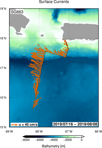
Glider-derived Ocean Currents
This web page provides access to surface and depth averaged ocean currents determined with underwater gliders.
Maps of Glider-derived Ocean Currents SG663
| SG663 | SG664 | SG665 | SG666 | SG667 | SG668 | SG670 |
 |  |
Surface currents are estimated by the underwater glider as the drift of the vehicle during the time when it is standing at the surface between dives, using GPS time and Location.
Underwater gliders use an accurate hydrodynamic model to determine the path of the vehicle in still water based on its speed and direction. Using this model, depth-averaged currents are determined by comparing the predicted surfacing location of the vehicle with the actual surfacing position according to the GPS. Depth average currents estimates have an accuracy of 0.01 cm/s and are assumed to act over the whole profile uniformly.