HWRF-B Development
Bridging the Gap Between Regional and Global Modeling
JUMP TO DATA
OR SCROLL TO LEARN MORE
Background
What is HWRF-B? Why do we need it?
HWRF-B is a basin-scale (across the Atlantic ocean basin) model of the Hurricane Weather Research and Forecasting (HWRF) project. The HWRF-B model gives us insight on how storms evolve inside and interact with other large-scale features, or even other storms. It has helped us gain valuable knowledge about excessive rainfall events (Harvey 2017) and multi-storm interactions (Matthew and Nicole 2016) that threatened our community. The HWRF-B’s progress throughout time can be attributed to its expansive intake of real-time observations, assimilation processes, and high-resolution algorithms to model the atmosphere.
Multi-Storm Interactions & Moving Nests
During hurricane season, there are typically multiple storms occurring simultaneously in a basin. In fact, up to four storms have occurred concurrently in the Atlantic basin (1998, 2008, 2018). Because of the impact this has on a forecast, HWRF-B plays a vital role by incorporating movable multi-layer nests and providing a new area of research in the near future.
Supporting the Weather Research & Forecasting Act of 2017
Under sections 101, 104, and 105 of the Weather Research and Forecasting Act of 2017, AOML as well as other academic collaborators are commissioned to the improvement of model forecasting and development for “the protection of life and property and the enhancement of the national economy,” and to “restore and maintain U.S. leadership in numerical weather prediction (processing weather data with computer models) and forecasting.” The ongoing HWRF-B and HAFS developments seek to satisfy and excel in these areas.
For more information on the Weather Research and Forecasting Act of 2017, click here.
Who We Are
Our Objectives
Our primary focus is to research, understand, and model the atmosphere to improve forecasting for tropical cyclones. We are integrating static-outer and movable-nest (inner) domains to facilitate large-scale factors and smaller mesoscale factors within storms. Using movable nests and static outer domains improves both track and intensity skill by incorporating mechanics in the atmosphere at various scales. We want to extend a special thank you to our additional collaborators including: Jun Zhang (UM/CIMAS), Da-Lin Zhang (University of Maryland), Qingfu Liu, Samuel Trahan, Zhan Zhang, and Vijay Tallapragada (NCEP/EMC).
What We Do
Our Objectives
Our aim is to develop a forecast system which can follow multiple storms simultaneously. This is done by implementing a multiple-moving nest system that allows forecasters to track large-scale systems and their evolution at the basin scale. It also shows key factors like hurricane related mesoscale convective features and multi-scale interactions.
To accomplish these objectives, we use advanced modeling software and a wide range of observation data. We use observations from radar, balloon soundings, aircraft, ships, and satellites. Read more about our current operations on the Hurricane Research Division’s Blog.
Realistic Atmospheric Modeling
With improved resolution, the HWRF-B model has the ability to represent and resolve small scale features inside hurricanes such as eyewall mesovortices and heavy bands of precipitation. Finer resolution modeling will allow for more localized forecasts to warn communities of specific conditions and impacts.
Accurate Rainfall Forecasting
The HWRF-B model displayed a notable amount of rainfall accuracy skill when tested in situations like Hurricane Harvey (2017) when excessive rainfall was possible. High-resolution representations of microphysics and convection within storms help to give HWRF-B a precise picture of how and why a storm produces precipitation.
Intensity Skill Improvement
Relative to the operational HWRF, the experimental HWRF-B performed around 16% better regarding intensity at a 5-day lead time in the Atlantic basin. With such a marked increase in skill, forecasters have a better handle on storm intensities and subsequent impacts to communities. Additionally, the improved forecast intensity skill can anticipate rapid changes in intensity.
Our Data
Below is a link to our data page, which offers a wealth of storm-centered and global model data. We provide global and storm centered “nest” plots, which include the HWRF-B model. A combination of the model guidance is essential to have a holistic view of active storms and weather patterns. Each model delivers a suite of data around six-hour increments, which covers winds at different levels of the atmosphere and various types of precipitation. Our data page also contains archives back to 2016 for model runs of different storms in the Northeast Pacific and Atlantic basins.
Transition to Operations
2018’s Best Model
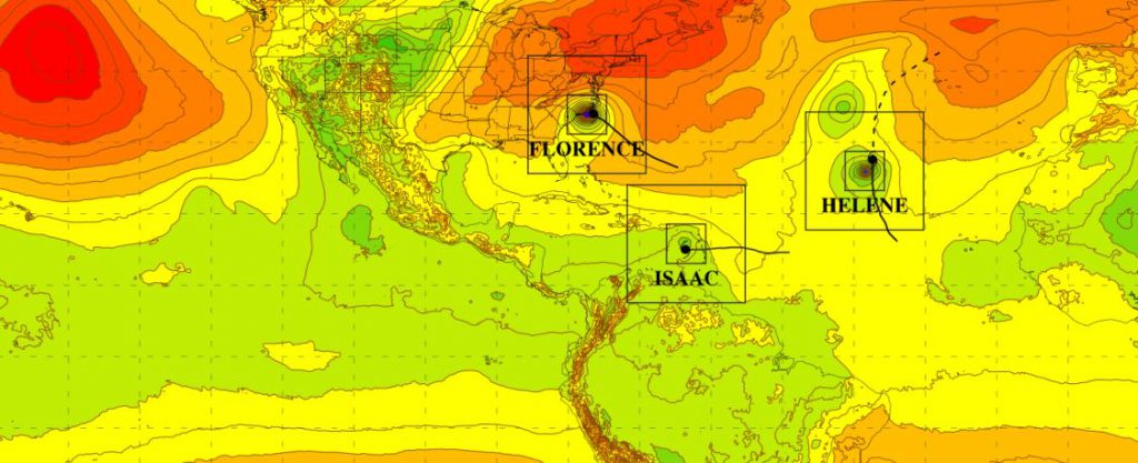
NOAA research has further developed this model to be a ‘basin-scale model’ that allows up to three storms to be embedded within the model at the same time. This allows each storm to be modeled using state of the art spatial scales while allowing the hurricanes to interact with each other. In 2018, this basin-scale model was the best NOAA research model and the only model to accurately predict the weakening of Hurricane Isaac as it interacted with Hurricanes Florence and Helene. For 2019, this model will be transitioned to run in a fully operational environment for testing and validation.
Featured Publication
Performance of Basin-Scale HWRF Tropical Cyclone Track Forecasts
Abstract: The Hurricane Weather Research and Forecasting model (HWRF) is a dynamical model that has shown annual improvements to its tropical cyclone (TC) track forecasts as a result of various modifications. This study focuses on an experimental version of HWRF, called the “basin-scale” HWRF (HWRF-B), configured with: (1) a large, static outer domain to cover multiple TC basins; and (2) multiple sets of high-resolution movable nests to produce forecasts for several TCs simultaneously. Although HWRF-B and the operational HWRF produced comparable average track errors for the 2011-2014 Atlantic hurricane seasons, strengths of HWRF-B are identified and linked to its configuration differences. HWRF-B track forecasts were generally more accurate compared to the operational HWRF when at least one additional TC was simultaneously active in the Atlantic or East Pacific basins and, in particular, when additional TCs were greater than 3500 km away. In addition, at long lead times, HWRF-B average track errors were lower than for the operational HWRF for TCs initialized north of 25°N or west of 60°W, highlighting the sensitivity of TC track forecasts to the location of the operational HWRF outermost domain. A case study, performed on Hurricane Michael, corroborated these HWRF-B strengths. HWRF-B shows potential to serve as an effective bridge between regional modeling systems and next generational global efforts.

June 19, 2019
More HWRF-B Publications
Click to Expand
Alaka Jr, G. J., Zhang, X., Gopalakrishnan, S. G., Goldenberg, S. B., & Marks, F. D. (2017). Performance of basin-scale HWRF tropical cyclone track forecasts. Weather and Forecasting, 32(3), 1253-1271.Gopalakrishnan, S. G., Srinivas, C. V., & Bhatia, K. T. (2016). The Hurricane Boundary Layer. In Advanced Numerical Modeling and Data Assimilation Techniques for Tropical Cyclone Prediction (pp. 589-626). Springer, Dordrecht.
Zhang, X., S.G. Gopalakrishnan, S. Trahan, T.S. Quirino, Q. Liu, Z. Zhang, G. Alaka, and V. Tallapragada, 2016: Representing Multiple Scales in the Hurricane Weather Research and Forecasting Modeling System: Design of Multiple Sets of Movable Multilevel Nesting and the Basin-Scale HWRF Forecast Application. Wea. Forecasting, 31, 2019–2034,
Goldenberg, S.B., S.G. Gopalakrishnan, V. Tallapragada, T. Quirino, F. Marks, S. Trahan, X. Zhang, and R. Atlas, 2015: The 2012 Triply Nested, High-Resolution Operational Version of the Hurricane Weather Research and Forecasting Model (HWRF): Track and Intensity Forecast Verifications. Wea. Forecasting, 30, 710–729,
Quirino, T. S., Delgado, J., & Zhang, X. (2014, August). Improving the Scalability of a Hurricane Forecast System in Mixed-Parallel Environments. In 2014 IEEE Intl Conf on High Performance Computing and Communications, 2014 IEEE 6th Intl Symp on Cyberspace Safety and Security, 2014 IEEE 11th Intl Conf on Embedded Software and Syst (HPCC, CSS, ICESS) (pp. 276-281). IEEE.
Looking for Literature? Search our Publication Database.

