Products from
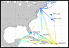
The products presented in this page were developed in a collaboration between the National Oceanic and Atmospheric Administration (AOML/NOAA), Royal Caribbean International, the University of Miami's Rosenstiel School of Marine and Atmospheric Science (UM-RSMAS) and the Southeast Atlantic Coastal Ocean Observing System (SEACOOS). The sea surface temperature (SST) and sea surface salinity (SSS) data used here came from a thermosalinograph that was part of the advanced atmospheric and oceanographic laboratory on board of Explorer of the Seas.
In December 2007 the maned operation in the Explorer of the Seas ceased. Real-time TSG data transmissions resumed in September, 2009 after the installation of a fully autonomous environmental observation system.