SAM, Southwest Atlantic MOC project
Variations in the Meridional Overturning Circulation (MOC) have been linked to changes in critical climate variables such as precipitation, surface air temperature, sea level and extreme weather (e.g. drought, heat waves, hurricane intensification) across the globe. The Southwest Atlantic MOC project (SAM), which began in 2009, seeks to capture the daily variability of key components of the MOC in a hitherto under-sampled region - the South Atlantic Ocean. Numerical climate models indicate that important water mass transformations are undergone by the MOC flows in the South Atlantic, and that these variations likely control the stability of the MOC flow itself, however little data has previously been available for the study of these flows in this region. The initial array deployed as part of the SAM project involved a zonal line of three pressure-equipped inverted echo sounders (PIES) and one current-and-pressure-equipped inverted echo sounder (CPIES) deployed near the western boundary at 34.5 S. In 2011 the CPIES was replaced with a PIES. Data from these instruments are used to monitor the Brazil Current and the Deep Western Boundary Current as they carry components of the MOC along the western boundary of the basin. Coupled with annual or semiannual hydrographic observations collected on an Argentine or Brazilian research vessel, these data are providing better understanding of the processes involved in MOC variability in the South Atlantic. The SAM array is funded by the NOAA Ocean Observing and Monitoring Division and the NOAA Atlantic Oceanographic and Meteorological Laboratory (AOML). It is maintained through a collaboration between AOML-PhOD and scientists in Argentina and Brazil. Additional collaborations with French and South African programs has led to a line of moorings across the entire basin called the South Atlantic MOC Basin-wide Array (SAMBA). SAMBA allows us to provide the continuous time series observations of trans-basin MOC flows at this latitude.
For more information about this project, the data collected, and the scientific publications that have resulted, please see the links under "SAM" in the top menu bar.
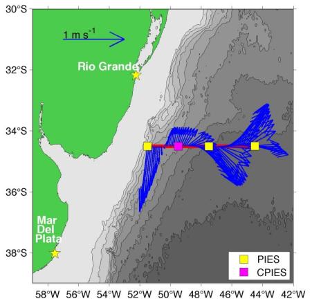
Figure: Map indicating the locations of the four PIES/CPIES instruments deployed as part of the SAM project. Also shown (blue arrows) are the near-surface velocities observed by the shipboard-ADCP onboard the Brazilian Navy research vessel Cruzeiro do Sul during the March 2009 deployment cruise.