What are upper ocean thermal data?
In the most general sense, upper ocean thermal data are measurements made in the top 1 to 2 kilometers of the ocean. Two important upper ocean measurements are temperature and salinity. These variables are measured at the ocean surface using floating buoys, sensors mounted on ship hulls, or satellite infrared imagery. Below the surface, measurements are made using expendable probes (XBT's or XCTD's), moored buoys or sub-surface floats (either vertically profiling or drifting at a specific depth or density.
A fairly typical example of a temperature profile in the Atlantic Ocean is shown in Figure 1. This Figure shows the temperature of the water as a function of depth below the sea-surface. This particular profile was taken in December 1997 aboard a volunteer Merchant Ship called the M/V Morelos at about 26°N, 74°W in the Altantic Ocean as part of AOMLs high density XBT project. The temperature profile is typical in that near the surface of the ocean the temperature is warmer (here greater than 25°C or about 78°F) and the temperature gradually decreases with increasing depth away from the sea-surface (here the temperature decreases to less than 10°C or less than 50°F by 700m).
What are upper ocean thermal data?
CloseWhy are upper ocean thermal data important?
Importance of Upper Ocean Thermal (UOT) Data
The need for UOT data has been extensively documented in the program plans of the large-scale climate and oceanographic programs. For example, UOT observations are given as the third highest priority, after SST and surface winds, in the plan for post-TOGA observations (NRC, 1994). Directed at "supporting short-term climate predictions" the post-TOGA UOT data are "central to the successful initialization of coupled atmosphere-ocean models". To date, UOT data have been shown to make a considerable improvement on predictive skill of NOAA's Coupled Model Project (CMP) model (Ji, 1994, personal communication).
In WOCE, "there is a need for measurements of the change in heat content in the upper ocean, primarily as a way to improve the reliability of estimates of the heat flux" (WMO, 1986). In ACCP, UOT data collection and analysis are supported to study the role of subsurface oceanic processes on decadal SST variability (Molinari et al., 1994). In these and other programs, UOT data are also required to increase understanding of oceanic dynamics and for numerical model verification. TOGA, WOCE, and ACCP recognize the need for continued oceanographic observations and have as an important objective the establishment of the long-term measurement networks that will constitute GOOS.
The objectives and methodology of the UOTC are directly relevant to the goals of several of the OGP components. ACCP requirements in the program announcement include: "modeling of the maintenance and variability of the relatively warm upper layer in the Grand Banks region and the sea surface temperature field of the tropical Atlantic" and "use of conceptual and numerical models to synthesize near surface data". Definition of climate signals and network evaluation studies will address both these requirements. Climate observations will "support design studies and observing system simulation experiments aimed at assessing the impact of ocean data on climate prediction". The network evaluation studies are directly applicable to this objective. Finally, "GOALS will support research in the areas of monitoring, data management, empirical studies, modeling and prediction", all objectives of the UOTC.
Why are upper ocean thermal data important?
CloseWhat is an XBT?
The Expendable Bathythermograph (XBT)
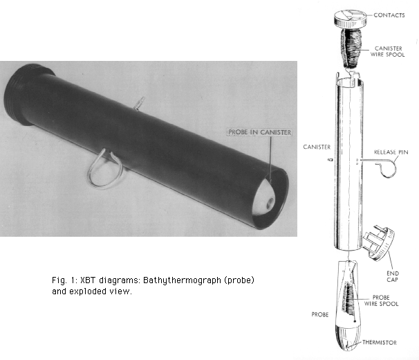 The Expendable Bathythermograph (XBT) has been used by oceanographers for many years to obtain information
on the temperature structure of the ocean to depths of up to 1500 meters. The XBT, shown in Figure 1, is a probe
which is dropped from a ship and measures the temperature as it falls through the water. Two very small wires
transmit the temperature data to the ship where it is recorded for later analysis. The probe is designed to fall
at a known rate, so that the depth of the probe can be inferred from the time since it was launched. By plotting
temperature as a function of depth, the scientists can get a picture of the temperature profile of the water.
The Expendable Bathythermograph (XBT) has been used by oceanographers for many years to obtain information
on the temperature structure of the ocean to depths of up to 1500 meters. The XBT, shown in Figure 1, is a probe
which is dropped from a ship and measures the temperature as it falls through the water. Two very small wires
transmit the temperature data to the ship where it is recorded for later analysis. The probe is designed to fall
at a known rate, so that the depth of the probe can be inferred from the time since it was launched. By plotting
temperature as a function of depth, the scientists can get a picture of the temperature profile of the water.
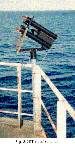 On many projects it is necessary to deploy XBTs on a 24 hour schedule as the ship steams along its course. Since
a trained operator is needed to operate the system, it was necessary to send two people so that operations could
be conducted around the clock. To reduce the workload, AOML has designed and is now testing an automated XBT
launcher that will allow this work to be conducted by only one person. Eventually, it is hoped, the ship's crew
will be able to operate the system and no operators will have to accompany the system.
On many projects it is necessary to deploy XBTs on a 24 hour schedule as the ship steams along its course. Since
a trained operator is needed to operate the system, it was necessary to send two people so that operations could
be conducted around the clock. To reduce the workload, AOML has designed and is now testing an automated XBT
launcher that will allow this work to be conducted by only one person. Eventually, it is hoped, the ship's crew
will be able to operate the system and no operators will have to accompany the system.
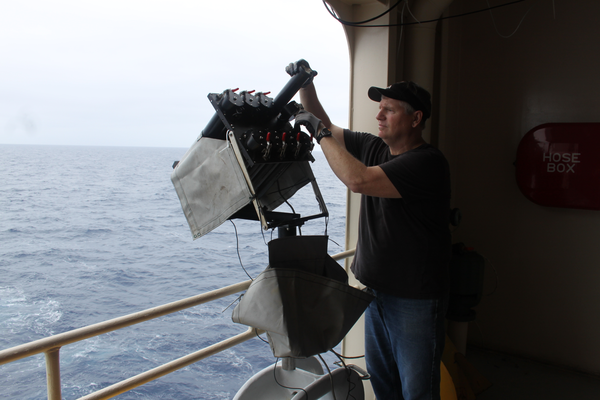
A photograph of the XBT Autolauncher is shown in Figure 2. Up to eight probes can be preloaded and then deployed at predetermined launch times or positions.
What is an XBT?
CloseHow are upper ocean thermal data collected?
UOT Data Collection
NOAA, other national groups and the international community have established several mechanisms for the collection of UOT data which are described below. An important consideration when designing these mechanisms for data acquisition is the sampling srategy necessary for particular scientific or operational needs.
To date, the primary source of UOT data has been the XBT Volunteer Observing Ship (VOS) program using Shipboard Environmental data Acquisition Systems (SEAS) for data collection and transmission. SEAS was developed by NOAA to provide accurate meteorological and oceanographic data in real time from ships at sea through the use of satellite data transmission techniques. The system transmits data through either the GOES or INMARSAT satellites to NOAA. Currently, SEAS has the capability to transmit surface weather, XBT, CTD and ADCP data.
Recently, two other observing systems have been deployed to provide UOT data. First, in the tropical Pacific, an array of moored buoys, the TOGA-TAO array, measures surface atmospheric and subsurface oceanographic variables for TOGA (Fig. 3). Although initially designed to observe surface wind fields, the TAO array provides continuous observations of UOT structure.
Second, Davis et al. (1992) describe a subsurface float that was originally developed to provide trajectories at preselected depths of the water column. The float is timed to return to the surface at desired intervals to transmit its position data through a satellite link to a land station. This ALACE float has since been modified to provide both temperature and salinity profiles obtained during its return to the surface.
In all three observing systems, the data are transmitted via satellite from the collection point to a land station where they typically undergo some quality control. The data are then retransmitted and captured by users such as CMP for various purposes. Data not transmitted in real-time are collected by data centers such as NODC, collated and then forwarded, at different intervals, to quality control centers for review. After editing, the data are returned to the data centers for storage and dissemination to other users.
How are upper ocean thermal data collected?
CloseHow are upper ocean thermal data collected?
XBT Quality Control
The following two papers describe the proceedures used at AOML to quality control XBT data:
How are upper ocean thermal data quality controlled?
CloseHow are upper ocean thermal data distributed to users?
NOAA/AOML UOTC Data Pipeline
The Global Temperature Salinity Profile Project (GTSPP) of the Intergovernmental Oceanographic Commission - a World Meteorological Organization, has developed a protocol for the transmission, quality control and distribution of real-time upper ocean temperature (UOT) data collected from volunteer observing ships (VOS).
The Shipboard Environmental data Aquisition System (SEAS) is used to transmit XBT, thermosalinograph and weather observations through the GOES or INMARSAT satellite to the NOAA gateway. The data are then distributed on a daily basis to NCEP for use in short term forecasting, and via the Global Telecommunications System (GTS) to the Marine Environmental Data Service (MEDS) of Canada for quality control.
Three times a week MEDS transmits the data to the National Oceanographic Data Center (NODC) of the USA.
How are upper ocean thermal data distributed to users?
Close