Frequently Asked Questions
What is an XBT?
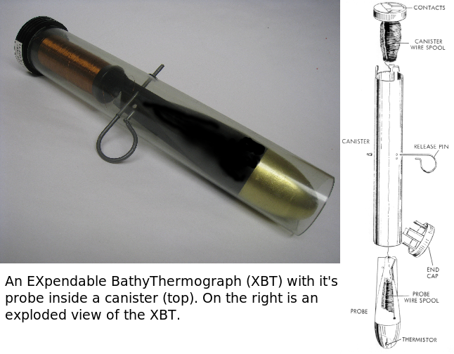
An eXpendable BathyThermograph (XBT) is a probe that is dropped from a ship and measures the temperature as it falls through the water. A resistance in the head of the probe and a very thin twin-wire, connecting the probe to the equipment on the ship, compose the electronic circuit for measuring the water temperature. The probe is designed to fall at a known rate, so that the depth of the temperature profile can be inferred from the time since it enters the water.
In a joint effort between research and government institutions and the private industry, XBTs are usually launched from cargo, research, or cruise ships. Deployments can be made using manual or automatic launchers (auto-launchers).
XBTs are mostly deployed along fixed transects which have been recommended by the international scientific and operational community.
 |
 |
 |
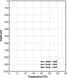 |
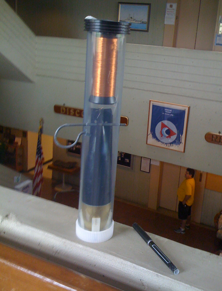
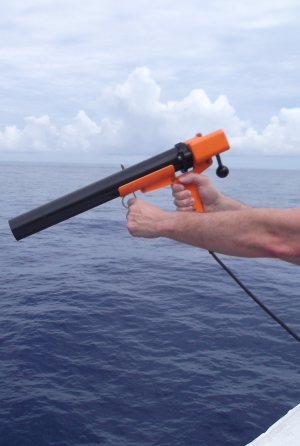
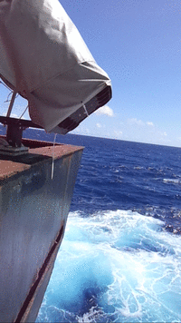
From left to right: (1) XBT probe; (2) XBT handlaucher; (3) Example of XBT deployment using an auto-launcher (AL) mounted on the stern of a Merchant Vessel. This model of AL is controlled from the cabin and can be loaded with up to 8 XBTs; (4) Example of real-time acquisition of a XBT temperature profile. The abrupt decrease in the temperature experienced by the XBT around 50 m is due to a feature called thermocline.
Further information on different XBTs models can be found in the Lokheed Martin Sippican , and TSK web pages.
topHow does an XBT measure depth?
XBTs do not measure depth directly (e.g. via pressure). Instead, fall-rate equations are used to derive the depth of the XBT as a function of time after the XBT is deployed into the ocean:
where z(t) is the depth of the XBT in meters, and a, b are constants determined using theoretical and empirical methods. For more information about the XBT fall rate equation and coefficients, please check the XBT bibliography. top
What is the XBT Network?
XBTs are mostly deployed along fixed routes that are referred as "transects". There are 49 XBT transects recommended by the scientific community in High Density (also referred as High Resolution) and Frequently Repeated modes. High Density transects are occupied at least 4 times per year and XBTs are deployed at approximately 25 km intervals along the ship track. Frequently repeated transects are occupied approximately 18 times per year with XBT deployments at 100 km intervals. Low Density mode (4 XBTs are deployed every 150-400 km along the ship track) has been largely discontinued in favor of Argo profiling floats. Several XBT transects have been occupied for more than 20 years.
The XBT network is very complex to maintain and a strong collaboration between many organizations and countries is needed. The logistics and problems linked to implementation of the XBT network are unique but with some common aspects with other observational platforms. The unique contribution provided by XBTs cannot be in general accomplished by any other single observational platform. However, there is a strong synergy between XBT observations and observations from other platforms, such as altimetry, surface drifters, Argo, etc.
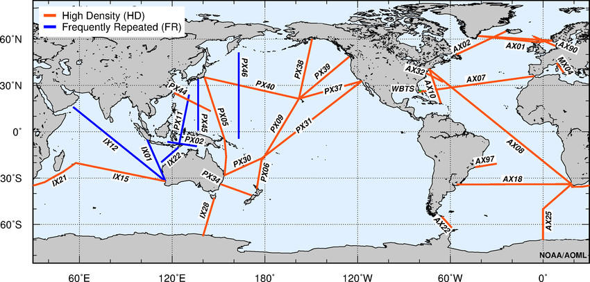
OceanObs09 Recommended XBT Transects.
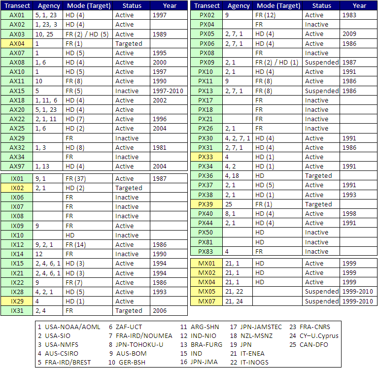
The table below provides information on the institutions participating in one or more aspects of the implementation of the XBT transects as agreed at SOT-7. The mode of deployment (FR-frequently repeated or HD-high density) as well as the target (recommended as 18 times/year for FR and 4 times/year for HD) are also indicated for 2011-2012. OceanObs09 recommended transects are shaded in green, while non-recommended transects are shaded in yellow.
Why are XBTs valuable?
XBTs are valuable because they:
- Represent the largest fraction of the temperature profile observations since 1970s and until the fully implementation of Argo profiling floats in approximately 2007.
- In recent years, 16,000 to 20,000 XBT are deployed each year, of which around 15,000 are distributed globally in real-time, representing close to 15% of the current total upper ocean thermal profile observations.
- Measure the seasonal and inter-annual fluctuations in the transport of mass, heat, and freshwater across transects, which define large enclosed ocean areas.
- Determine the long-term mean, seasonal cycle, and inter-annual fluctuations of temperature, geostrophic velocity and large-scale ocean circulation in the top 800 m of the ocean.
- Provide long time-series of temperature profiles at approximately repeated locations in order to unambiguously separate temporal from spatial variability.
- Determine the space-time variability of temperature and geostrophic shear fields.
- Provide appropriate in situ data (together with Argo profiling floats, tropical moorings, air-sea flux measurements, sea level etc.) for testing ocean and ocean-atmosphere models.
