Background
Where do we measure?
Numerical and analytical model studies indicate that higher latitudes (32-35S) are the best location for a trans-basin MOC array for several reasons. First and foremost, higher latitudes provide larger dynamic range in the zonal density gradients, leading to improved signal-to-noise characteristics for geostrophic velocity calculations. Second, ocean model studies indicate that at higher latitudes it is possible to utilize less expensive mooring technologies, such as pressure equipped inverted echo-sounders (PIES), reducing the cost of the overall measurements. Third, measurement of the stability of the MOC, a function of the baroclinic salt flux, can best be measured at the southern boundary of the Atlantic, nominally along 34.5S.
Following the community recommendation that a SAMOC monitoring array be located at 32-35S, the SAMoc Basin-wide Array (SAMBA) has been established along 34.5S. The array includes 20-30 deep ocean moorings, a combination of tall moorings and pressure-equipped inverted echo sounders, coupled with several shorter direct velocity moorings on the shelf on either side of the basin. Funds are also being sought to augment the trans-basin array through the addition of more moored instruments, for example to better sample transport streams by the different water masses on the western boundary continental shelf and slope. SAMBA measurements will be analyzed in concert with data from the SAMOC observational network which includes moored arrays at other latitudes, repeat shipboard (XBT and CTD) transects, Argo profiling floats, surface drifting buoys, and satellites.
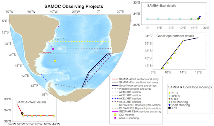
Schematic of SAMOC observational network as of February 2016.
Figure from Chris Meinen.