
Sea level rise is one of the most challenging consequences of global warming. A new collaborative study led by Dr. Denis Volkov from NOAA-AOML and the University of Miami’s Cooperative Institute of Marine and Atmospheric Studies found that Atlantic Meridional Overturning Circulation (AMOC) induced changes in basin-wide ocean heat content are influencing the frequency of floods along the United States southeastern coast.
The meridional overturning circulation is a system of ocean currents that moves heat, salt, freshwater, and other properties around the Earth and throughout the global climate system. There is a surplus of heat in the tropics relative to the poles due to incoming solar radiation. The ocean, specifically the AMOC, plays a key role in transporting this heat to the subpolar North Atlantic, thus regulating global and regional climate, weather, and sea levels.
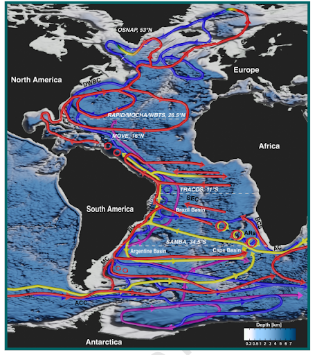
Idealized schematic of the overturning circulation in the Atlantic Ocean. The schematic represents the pathways of surface (red), intermediate (yellow), deep (blue), and abyssal (purple) waters over the bottom topography (blue shading). Transitions between these colors indicate water mass transformations. Important currents and topographic features mentioned in the text are labeled, and dashed white lines indicate the nominal latitudes of the five AMOC monitoring arrays. Figure reproduced from Chidichimo et al. (2023).
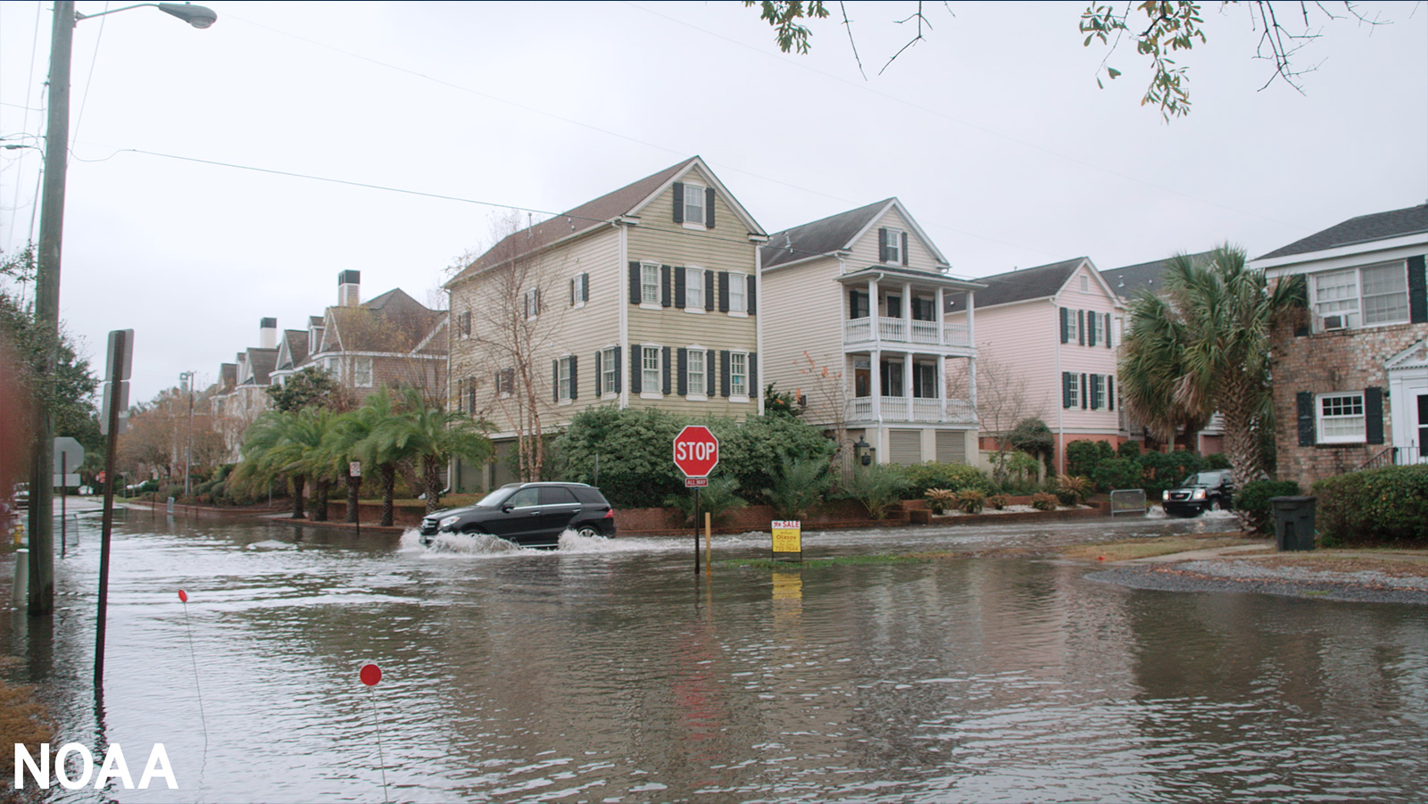
As polar ice sheets continue to melt and ocean warming intensifies, sea levels are projected to rise by over half a meter by the end of the century. Due to oceanic and atmospheric conditions, sea level changes vary by location, with some regions rising much faster than the global average. The U.S. east coast has been identified as a hotspot for accelerated sea level rise in the North Atlantic.
Climate models suggest a potential slowdown in the strength of the AMOC towards the end of the century due to anthropogenic (man-made) forcing. This slowdown is expected to speed up coastal sea level rise along the western boundary of the North Atlantic, which will dramatically increase flood risk.
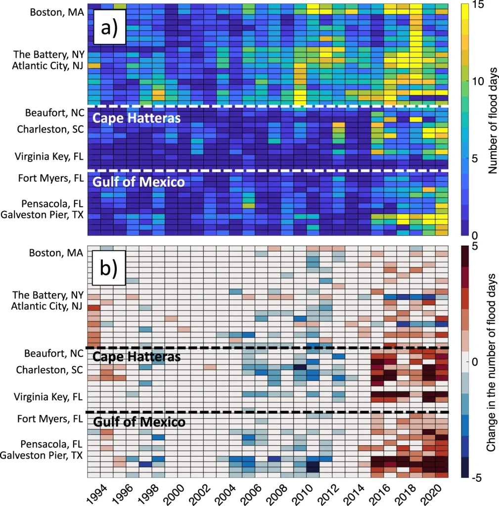
a) The number of flood days per year between 1993 and 2020 at each tide gauge used in this study (indicated on the vertical axis). A flood day is defined as the day when the water level exceeds the Minor flood threshold for 1 h or more. b) The difference between the actual number of flood days and the number of flood days after subtracting the tripole-related sea level from tide gauge records. The positive/negative values indicate years and tide gauges, when and where the North Atlantic SSH tripole was increasing/decreasing the frequency of floods. The horizontal dashed lines show the approximate locations of Cape Hatteras and the boundary between the U.S. Atlantic and Gulf coasts.
The new study explored an alternative mechanism, which showed changes in the AMOC control the redistribution of heat in the ocean and cause large-scale warming and cooling, with the associated sea level increase and decrease, respectively. Specifically, when the subtropical North Atlantic warms and its sea level increases, the subpolar North Atlantic and the tropics cool and their sea levels decrease, and vice versa. This natural variability pattern is known as the North Atlantic sea surface height tripole.
AMOC-induced heat redistribution led to a substantial warming in the subtropical North Atlantic in 2010-2015, accelerated sea level rise along the South Atlantic Bight and Gulf of Mexico coasts, and accounted for 30-50% of local flood days in 2015-2020.
The study demonstrates the importance of accounting for natural, large-scale sea level variability to improve coastal sea level projections and to better assess coastal flood risks. It also highlights the particular value of continued measurements obtained at ~26.5°N by projects such as RAPID, MOCHA, and WBTS, as well as observations from satellite altimetry and the Argo program.